Review Rock cycle & Topo map - cms15-16
advertisement
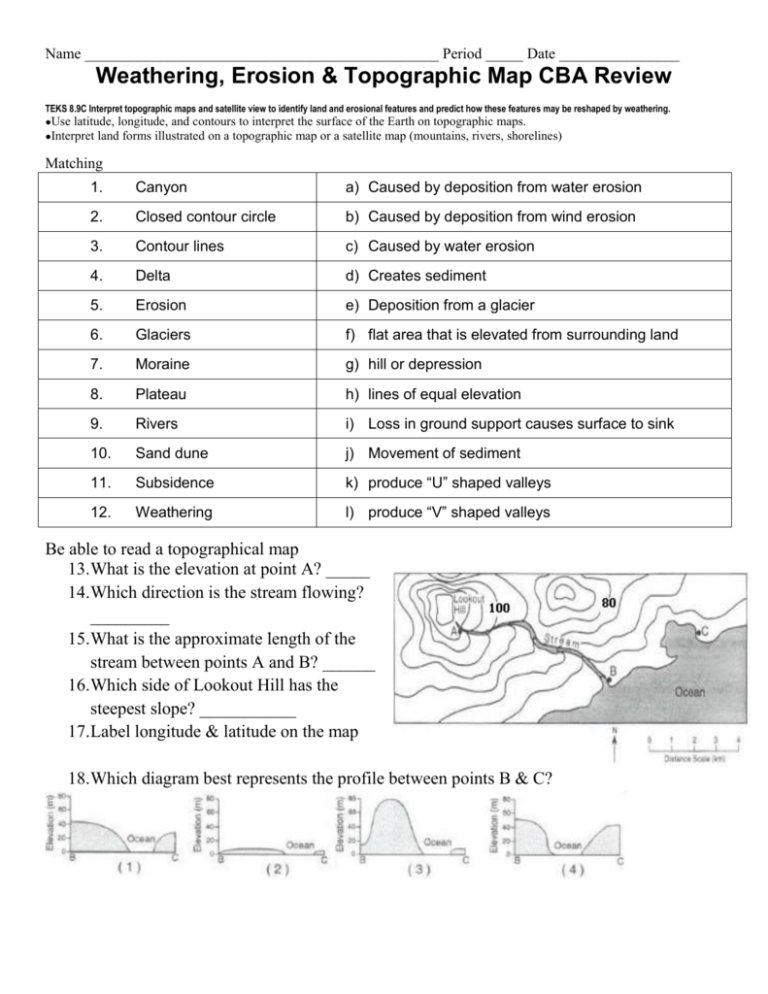
Name _______________________________________________ Period _____ Date ________________ Weathering, Erosion & Topographic Map CBA Review TEKS 8.9C Interpret topographic maps and satellite view to identify land and erosional features and predict how these features may be reshaped by weathering. ●Use latitude, longitude, and contours to interpret the surface of the Earth on topographic maps. ●Interpret land forms illustrated on a topographic map or a satellite map (mountains, rivers, shorelines) Matching 1. Canyon a) Caused by deposition from water erosion 2. Closed contour circle b) Caused by deposition from wind erosion 3. Contour lines c) Caused by water erosion 4. Delta d) Creates sediment 5. Erosion e) Deposition from a glacier 6. Glaciers f) flat area that is elevated from surrounding land 7. Moraine g) hill or depression 8. Plateau h) lines of equal elevation 9. Rivers i) Loss in ground support causes surface to sink 10. Sand dune j) Movement of sediment 11. Subsidence k) produce “U” shaped valleys 12. Weathering l) produce “V” shaped valleys Be able to read a topographical map 13.What is the elevation at point A? _____ 14.Which direction is the stream flowing? _________ 15.What is the approximate length of the stream between points A and B? ______ 16.Which side of Lookout Hill has the steepest slope? ___________ 17.Label longitude & latitude on the map 18.Which diagram best represents the profile between points B & C? 19. Label the following crustal features from the picture: Basin, Butte, Canyon, Mesa, Plateau A. B. C. D. E. 20. Where would eroded sand collect in the picture above? _____________________________ Label each of the following as physical or chemical weathering. 21. Burrowing Animals 22. Freezing and Melting of water 23. Sand blasting 24. Lichens secreting enzyme to break down rock 25. Rusting of Rocks 26. Water dripping through cave to form Stalagmite 27. What kind of climate weathers rock the fastest? _____________________________________________ 28. What 3 other things determine the rate rock breaks down? A. _________________ B. _________________ C. _________________ 29. Label which one shows latitude and which is longitude. A. ___________________ B. ________________ 30. Describe the role of weathering, erosion, and deposition in the formation of an Oxbow lake. Weathering – Erosion – Deposition – 2 TEKS 6.10B_Classify rocks as metamorphic, igneous, or sedimentary by the processes of their formation which type of rocks are associated with geologic features such as mountains, Rivers, beaches, sand dunes, and volcanoes. ●Know Matching: 31. Melting and Cooling form this type of rock a. Extrusive Igneous 32. Magma that has cooled inside the earth & has large grains b. Igneous 33. Lava that has cooled & has small grains c. Intrusive Igneous 34. Heat and Pressure form this rock d. Metamorphic 35. Forms from Weathering/Eroding then is compacted/cemented e. Organic 36. Example of Sedimentary Rock f. Sandstone 37. Forms from living things g. Sedimentary Rock Minerals 38. 39. If a mineral were scratched by glass but it scratched a penny what level of hardness would it be ranked on the scale? _____________ Use the mineral identification key to describe the properties of: A. Hornblende. B. Feldspar 3 4

