Permit Application - The Conservation Registry
advertisement
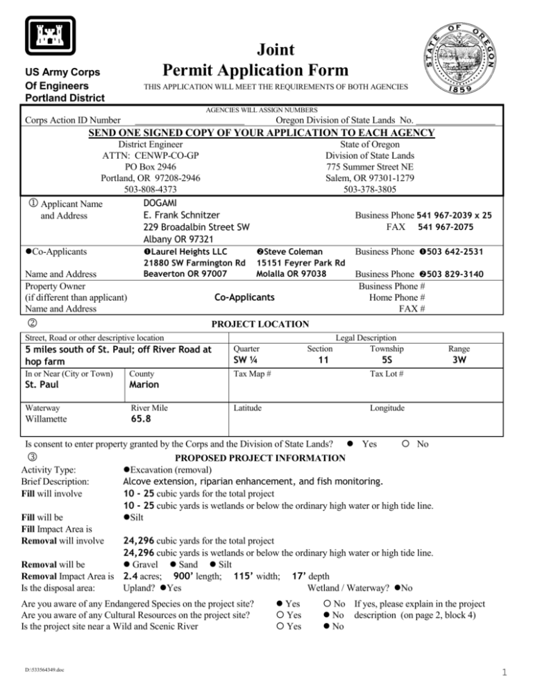
US Army Corps Of Engineers Portland District Joint Permit Application Form THIS APPLICATION WILL MEET THE REQUIREMENTS OF BOTH AGENCIES AGENCIES WILL ASSIGN NUMBERS Corps Action ID Number Oregon Division of State Lands No. SEND ONE SIGNED COPY OF YOUR APPLICATION TO EACH AGENCY District Engineer State of Oregon ATTN: CENWP-CO-GP Division of State Lands PO Box 2946 775 Summer Street NE Portland, OR 97208-2946 Salem, OR 97301-1279 503-808-4373 503-378-3805 DOGAMI Applicant Name E. Frank Schnitzer Business Phone 541 967-2039 x 25 and Address FAX 541 967-2075 229 Broadalbin Street SW Albany OR 97321 Co-Applicants Business Phone 503 642-2531 Laurel Heights LLC Steve Coleman Name and Address Property Owner (if different than applicant) Name and Address 21880 SW Farmington Rd Beaverton OR 97007 15151 Feyrer Park Rd Molalla OR 97038 Co-Applicants Business Phone 503 829-3140 Business Phone # Home Phone # FAX # PROJECT LOCATION Street, Road or other descriptive location Legal Description Section Township 5 miles south of St. Paul; off River Road at hop farm Quarter In or Near (City or Town) County Tax Map # Tax Lot # St. Paul Marion Waterway River Mile Latitude Longitude Willamette 65.8 SW ¼ 11 5S Range 3W Is consent to enter property granted by the Corps and the Division of State Lands? Yes No PROPOSED PROJECT INFORMATION Activity Type: Excavation (removal) Brief Description: Alcove extension, riparian enhancement, and fish monitoring. Fill will involve 10 - 25 cubic yards for the total project 10 - 25 cubic yards is wetlands or below the ordinary high water or high tide line. Fill will be Silt Fill Impact Area is Removal will involve 24,296 cubic yards for the total project 24,296 cubic yards is wetlands or below the ordinary high water or high tide line. Removal will be Gravel Sand Silt Removal Impact Area is 2.4 acres; 900’ length; 115’ width; 17’ depth Is the disposal area: Upland? Yes Wetland / Waterway? No Are you aware of any Endangered Species on the project site? Are you aware of any Cultural Resources on the project site? Is the project site near a Wild and Scenic River D:\533564349.doc Yes Yes Yes No If yes, please explain in the project No description (on page 2, block 4) No 1 PROPOSED PROJECT PURPOSE & DESCRIPTION Project Purpose and Need: The project proposes to extend an alcove and connect it to floodplain gravel ponds dug in the 1960-70s. The purpose is to provide a fish ingress/egress channel via a low-water connection designed to prevent stranding of native fish and potentially to improve fish access to the floodplain. The need for this project is based on the degradation by simplification of the Willamette River and its floodplain over the last 150 years. This project will enhance connectivity between the Willamette River and its floodplain. Currently only limited information is available on the utility of constructed fish channels. Many are now proposed to meet ESA requirements for commercial floodplain gravel operations. The primary objective of this project is to monitor fish usage of the constructed channel to improve the current body of knowledge for fish passage between floodplain ponds and rivers and then disseminate that information. Project Description: Project Setting Mahony Bar is situated on the right (east) channel bank of the Willamette River and comprises 17 acres. It has been a persistent feature on the river since prior to the 1930s; small-scale aggregate extraction occurred primarily in the 1960s and 70s. These operations occurred on both ODOT property and private property (Figure 1). Mahony Bar floods on a frequent basis. Flood frequency across the bar varies from annual to periodic flows. Consequently, migratory fish may enter the ponds as they seek refuge during higher velocity events. Monitoring at other floodplain mine ponds on the Willamette River suggest not all migrants leave with the receding river. Fish remaining after the flood are stranded until the next flood event or perish through predation or elevated water temperatures. The plan is a series of integrated steps designed to be compatible with local flood hydrology and geomorphic trends. These actions will promote fish passage and floodplain complexity at Mahony Bar. Fish usage, water quality, geomorphic stability, and riparian plantings will be monitored for five years. Vegetation and Soils Historically, vegetation composition on the bar was different than it is now. In the past, frequent scouring from flood events and deposition across Mahony Bar limited vegetation establishment. Through the 1930s, 40s, and 50s, the upstream end was an open bar subjected to more frequent flooding and deposition. This limited vegetation to early successional species. Based on photos, historic vegetation appeared to be limited to a few clumps of willows, annual grasses, and forbs. Presently, undisturbed sections of Mahony Bar in the project area have a thick cover of riparian vegetation. It is dominated by an even-aged stand of Oregon ash and black cottonwood trees. The trees are approximately 30 to 40 years old. Understory species include Himalaya blackberry, choke cherry, pacific ninebark, annual grasses, and forbs. Several species of willows are also present. Figure 2 delineates existing features on Mahony Bar. At the downstream end of Mahony Bar, a mature lowland riparian forest is present. Big Leaf Maple, Oregon Ash, and black cottonwood are the dominant tree species. Understory species include vine maple, pacific nine bark, choke cherry, and snowberry. This riparian forest is present in the 1936 aerials and based on appearances, is 80 to 100+ years old. Mahony Bar was mapped by the Soil Conservation Service as alluvial land, meaning it is composed of loose sand and gravel with areas of silt loam. The distribution of these materials on the bar is indicative of the hydrologic conditions. The upstream section is composed of embedded and loose sand and gravel. The lower end of the bar has a uniform deposit of silt 4 to 5 feet thick across the surface (test pits dug in May 2002). Site Hydrology and Geomorphic Setting The site hydrology, including flood frequency and depth to ground water on Mahony Bar, is controlled by the Willamette River stage height. Most areas on the bar are submerged during a five-year event. Most of Mahony Bar receives flood waters in this manner. Low velocity backwater conditions allow silts to continually be deposited. There are no surficial deposits of sand and gravel over the downstream two thirds of the bar (project site). Near the entrance of the access road to the ODOT property, geomorphic conditions indicate flooding for the upper third of the bar is not primarily a back water condition. Due to its lower elevation, this section of the bar is subject to inundation by overbanking of flood waters directly from the channel and into the ODOT excavation. No activity is planned in this area. D:\533564349.doc 2 Flood Frequency and Velocity The Army Corps of Engineers completed a flood insurance study for this reach in 1979. River cross-section 66.32 and river section 65.58 are located within the project area. A more recent model (December 2002), using HEC-RAS, has been constructed for this reach of the river by Lidstone and Associates (LA). According to the most recent model, the two year flood elevation at Mahony Bar is ~89 feet. Natural elevations across the bar range from 86 to 95 feet. Vegetation and the size of bedload deposition suggest that velocities near river section 66.32 bar may range from 1 to 5 feet/second. This velocity range is desirable for expecting that vegetation can provide good bank stability functions. Mine History and Impacts Bar scalping first began at Mahony Bar sometime between 1955 and 1963. It appears that the most active time for mining was in the late 60s and early 70s. The 1970 aerial shows shallow sand and gravel excavation sites on the upper third of Mahony Bar. They impacted approximately 14 acres. ODOT Property Mining has left a floodplain depression 5 to 15 feet below ground surface. The disturbed boundary, including soil berms, totals ~ 5 acres. A leave strip of ~200 feet was left between the river channel and the excavations. The mine areas were developed by pushing the silt and sand deposits toward the channel and into the trees. The footprint of these spoil areas are discernable by a thick cover of Himalaya blackberries. Most of the excavation banks are angle of repose slopes. Irregular excavation boundaries were left and now have a complete vegetative cover. The ODOT excavation seasonally ponds water and is controlled by the river stage. Coleman Ponds The Coleman ponds were mined to a depth of 5 to 20 feet. Localized areas where mining depths were deeper have allowed year round ponds. The ponds’ boundaries are irregular. Similar to the ODOT areas, the overburden has been pushed toward the channel. The upstream Coleman pond holds water year-round during most years. The downstream end where the fish connection is proposed is less than 10 feet deep. Increasing the pond depth at the downstream end by excavating an additional 10 feet at this location would improve water quality in the summer and may benefit year-round fisheries use. Vegetation establishment for the Coleman Ponds is similar to the ODOT pond bank described above. The specific project objectives are: Deepen ½ acre at downstream end of Coleman pond to expose a minimum of 6 feet of ground water Extend natural alcove to the downstream end of the Coleman pond Remove soil berm blocking fish and wildlife movement between excavation areas on the Coleman property Remove silt blocking inlet to alcove #1 Realign alcove inlet and place LWD according to design by ODFW Habitat Biologist, Joe Sheahan. Design intent is to encourage localized scouring and limit silt deposition and blinding off of the alcove inlet Place LWD in alcove extension and minimize reestablishment of reed canary grass by an aggressive tree and shrub plantings along alcove banks Evaluate the biological benefits and geomorphic stability of the alcove extension By data collection, add to body of knowledge regarding creation of fish access channels to mine ponds. Collect data on fish assemblages, fish populations, and life stages. Evaluate project benefits to other wildlife species. Monitor dissolved oxygen and temperature pre and post-construction Berm Removal This area contains angle of repose soil piles perpendicular to the movement of flood water. The berm is a barrier between the upstream end of the Coleman pond (upland mine site) and the deeper portions located upstream. It is vegetated with annual and perennial grasses and small patches of blackberries. Alcove Extension This area is 900 feet long by 200 feet wide at elevation 87 feet. All of the vegetation in this area is reed canary grass. It also encompasses a ¼ acre sized area where trees are present along the edge of the alcove. Field surveys indicate that the alcove extension will require the removal of 3 clumps of Oregon Ash and a single stem. Each clump has 4-6 stems. The stem diameter range from 4 to 8 inches. Approximately 10 Oregon Ash trees with an average diameter of 7 inches will need to be removed. Live trees will be buried in the slopes of the alcove extension for propagation of new trees. D:\533564349.doc 3 The dimensions of the proposed extension will be 4:1 (H:V) cutslopes in silts and 2:1 (H:V) cutslopes in sand and gravel with a bottom width of 20 feet. Approximately 6,666 cubic yards of silt will be excavated; 3,600 cubic yards will be hauled and placed at or below grade in the scalped area within the upland mine disturbance; and 1,000 cubic yards will be removed from the bar and stockpiled for use on the hops field. The remaining silt (~2,066) will be placed within the upland mine disturbance. Approximately 17,600 cubic yards of sand and gravel will be excavated from the alcove extension and removed from the site. Alcove #1-Inlet Reshaping The alcove disconnected from the channel in 2002, when the Salem gage dropped to 7,800 cfs on July 1. A track back hoe can access this location without removing any trees. Some shrubs may be impacted, but a road will not be built. The track hoe will haul in the LWD from the staging site. The LWD will be placed prior to excavation of silts at the inlet entrance. A total of 10 to 20 cubic yards of silts will be removed from the inlet. The excavated material will be placed and leveled in an open area downstream of the inlet and above ordinary high-water elevation. Connection Point Between Alcove #1 and the Alcove Extension The terminal end of the alcove has an in-water slope of 10:1 or flatter at the proposed connection point. Silts are exposed here. The area is not vegetated because it is under water approximately half of the year. In the adjacent uplands, the reed canary grass is present with alders along the ordinary high water line of the alcove. To complete the connection between the constructed alcove and the natural feature, no trees will be removed. The connection point will be excavated to match the bottom elevation of the natural alcove (~5 feet below low water). Pond Deepening and Silt Disposal To provide year-round ponding of ground water, a half-acre area of the Coleman pond will be deepened by an additional 10 feet to provide a minimum of 6 feet of water during low-flow conditions. In the deepening process, all pond banks steeper than 3:1 (H:V) will be flattened with an excavator. The excavated material will primarily be sand and gravels. The volume proposed for removal is 2,600 yards. Within the mine area where silts have been scalped, a disposal trench 100’ by 30’ wide by 15’ deep will be excavated and filled with silts. All silts will be placed below grade of the FEMA floodway elevation of 86 feet (Figure 3). Excavation and Placement Volumes Removal* Silt Placement (in yards) Silt Sand & Gravel (in yards) Alcove entrance 25 0 251 Berm removal 50 0 502 6,666 17,600 0 0 2,600 2,0662 0 3,600 3,600 0 0 1,000 Alcove extension Coleman Pond (upland mine pond) Silt disposal trench (100’ x 30’ x 12’ deep) Hop field (upland) *All sand and gravel will be removed from the site. 1 Revegetate in place above 2-year flood elevation. 2 Place adjacent to upland mine pond where soils have been excavated and removed from project site. Construction Sequence The construction sequence has been designed to minimize impacts to water quality and fisheries during construction. All areas disturbed will be revegetated with sterile wheat to provide quick cover. Native trees and shrubs will then be D:\533564349.doc 4 established at elevations suitable for their individual survival requirements. The construction activities are planned for July or August after alcove #1 disconnects from the mainstem in the following sequential steps: 1. 2. 3. 4. 5. The berm blocking fish passage will be removed and used to flatten the pond banks in the immediate vicinity. The downstream end of the Coleman pond will be deepened. The alcove extension will be excavated and shaped. The alcove extension will be connected to the natural alcove. The alcove inlet will be shaped by removing silts and adding LWD. DOGAMI personnel will be on-site to monitor turbidity. A sand and gravel coffer dam will be built to trap turbidity, if required. Most likely, the rate of equipment movement can be regulated to control turbidity excursions and maintain activities within the 10 percent rule at the sampling point 100 feet downstream. Additional details regarding existing conditions and the proposed project are provided in the draft biological assessment included with this application. How many project drawing sheets are included with this application? Located in attached Biological Assessment NOTE: A complete application must include drawings and a location map submitted on separate 8½ X 11 sheets. Will any material, construction debris, runoff, etc. enter a wetland or waterway? Yes No If yes, describe the type of discharge (above) and show the discharge location on the site plan. Estimated Start Date: August 15, 2003 Estimated Completion Date: September 15, 2003 PROJECT IMPACTS AND ALTERNATIVES Describe alternative sites and project designs that were considered to avoid impacts to the waterway or wetland. A “no action” alternative would allow fish barriers to remain in place. If improvements are to be made to enhance or create fish egress out of man-made ponds when the river stage drops during the summer months, no alternative site or project designs are possible or practicable with one exception. A natural flood channel could also be enhanced as a method for alcove extension. Enhancement would require road building and a significant amount of tree removal to provide access to adequately deepen the natural flood channel. The extension of the alcove through the open section of the bar dominated by reed canary grass was developed as the preferred alternative. This would eliminate the need to remove trees. This preferred location also provides a better hydraulic alignment between the Coleman pond alcove #1. Describe what measures you will use (before and after construction) to minimize impacts to the waterway or wetland. See following page. ADDITIONAL INFORMATION Adjoining Property Owners and Their Address and Phone Numbers ODOT – Bernie Kleutsch 355 Capitol Street NE Room 301 Salem, OR 97301 (503) 986-3266 Has the proposed activity or any related activity received the attention of the Corps of Engineers or the State of Oregon in the past, e.g., wetland delineation, violation, permit, lease request, etc.? Yes No If yes, what identification number(s) were assigned by the respective agencies: Corps # State of Oregon # D:\533564349.doc 5 (continued) Describe what measures you will use (before and after construction) to minimize impacts to the waterway or wetland. Conduct work during summer low flow conditions No on-site fueling of equipment No road building or tree removal to reshape alcove inlet Revegetate all bare areas where mineral soils are exposed using a temporary cover that won’t provide long-term competition to native grasses Mulch bare mineral soils with straw Use turbidity meter to monitor turbidity - project to shutdown if LWD placement or reshaping at alcove inlet causes exceedance of background levels by more than 10 percent Dig and shape alcove extension prior to connection to natural alcove Plant trees and shrubs on 10 x 10 spacing - large/older plant material will be used to provide a competitive advantage over the reed canary grass. Planted species include willows, cottonwood, Oregon ash and alder trees. The will be planted at elevations appropriate for their long-term survival. Establish weed barriers for tree and shrub plantings Irrigate for one or two years to ensure survival of the planted species If needed, to control turbidity excursions into the river, hay bales will be keyed in and extended across the alcove inlet feature during excavation to connect the alcove extension to the natural alcove. Place LWD structures at ~50 foot intervals in the alcove extension under the direction of Joe Sheahan, ODFW Place silt soils excavated from alcove extension as follows: 1) on upper terraces stockpile in hop field 2) in disposal trench Establish willow stakes along pond banks and at the excavation site where berm removal occurs within the pond Monitor success for a period of 5 years Exclude cattle grazing D:\533564349.doc 6 City / County Planning Department Affidavit (to be completed by local planning official) This project is not regulated by the local comprehensive plan and zoning ordinance. This project has been reviewed and is consistent with the local comprehensive plan and zoning ordinance. This project has been reviewed and is not consistent with the local comprehensive plan and zone ordinance. Consistency of this project with the local planning ordinance cannot be determined until the following local approval(s) are obtained: Conditional Use Approval Plan Amendment Other Development Permit Zone Change An application has has not been made for local approvals checked above. Signature of local planning official Title City / County COASTAL ZONE CERTIFICATION Date If the proposed activity described in your permit application is within the Oregon coastal zone, the following certification is required before your application can be processed. A public notice will be issued with the certification statement which will be forwarded to the Oregon Department of Land Conservation and Development for its concurrence or objection. For additional information on the Oregon Coastal Zone Management Program, contact the department at 1175 Court Street NE, Salem, Oregon 97310 or call 503-373-0050. CERTIFICATION STATEMENT I certify that, to the best of my knowledge and belief, the proposed activity described in this application complies with the approved Oregon Coastal Zone Management Program and will be completed in a manner consistent with the program. Print /Type Name Title Applicant Signature Date SIGNATURE FOR JOINT APPLICATION Application is hereby made for the activities described herein. I certify that I am familiar with the information contained in the application, and, to the best of my knowledge and belief, this information is true, complete, and accurate. I further certify that I possess the authority to undertake the proposed activities. I understand that the granting of other permits by local, county, state or federal agencies does not release me from the requirement of obtaining the permits requested before commencing the project. I understand that payment of the required state processing fee does not guarantee permit issuance. Print /Type Name Title Applicant Signature Date I certify that I may act as the duly authorized agent of the applicant. Print /Type Name Title Authorized Agent Signature Date D:\533564349.doc 7 SUPPLEMENTAL WETLAND IMPACT INFORMATION* (For Wetland Fills Only) Site Conditions of impact area Impact area is Freshwater Wetland Note: Estuarian Resource Replacement is required by state law for projects involving intertidal or tidal marsh alterations. A separate Wetlands Resource Compensation Plan may be appended to the application. Has a wetland delineation been completed for this site? Yes No Describe the existing Physical and biological character of the wetland/waterway site by area and type of resource. A wetland delineation has not been completed. Vegetation is exclusively reed canary grass, a facultative wet species; they generally can be present in wetlands. May 2002 test pits measured ground water level 9’ below ground surface. The test pits were examined by a soil scientist. An average thickness of 5 feet of silts over sand and gravel were recorded. No mottling or gleying or other evidence of hydric soils were observed in test pits. The presence of reed canary grass may be indicative of poor drainage in the silt bed. However, for the purposes of this application, the applicant assumes that it is a regulated wetland. Resource Replacement Mitigation Describe measures to be taken to replace unavoidably impacted wetlands resources. Slope edge of alcove extension at 4:1 (H:V). Slope pond banks at 5:1 (H:V). Establish willows and large cottonwood stakes and seedlings to provide competitive advantage over re-establishment of reed canary grass. Plant willows at 1-2 foot centers and cottonwoods at 10-12 foot centers. *Because this information is not necessary for a complete application, you may submit this sheet and other environmental information after submitting your application. 07/98 D:\533564349.doc 8
