The Mexican Cession, 1848-1853
advertisement
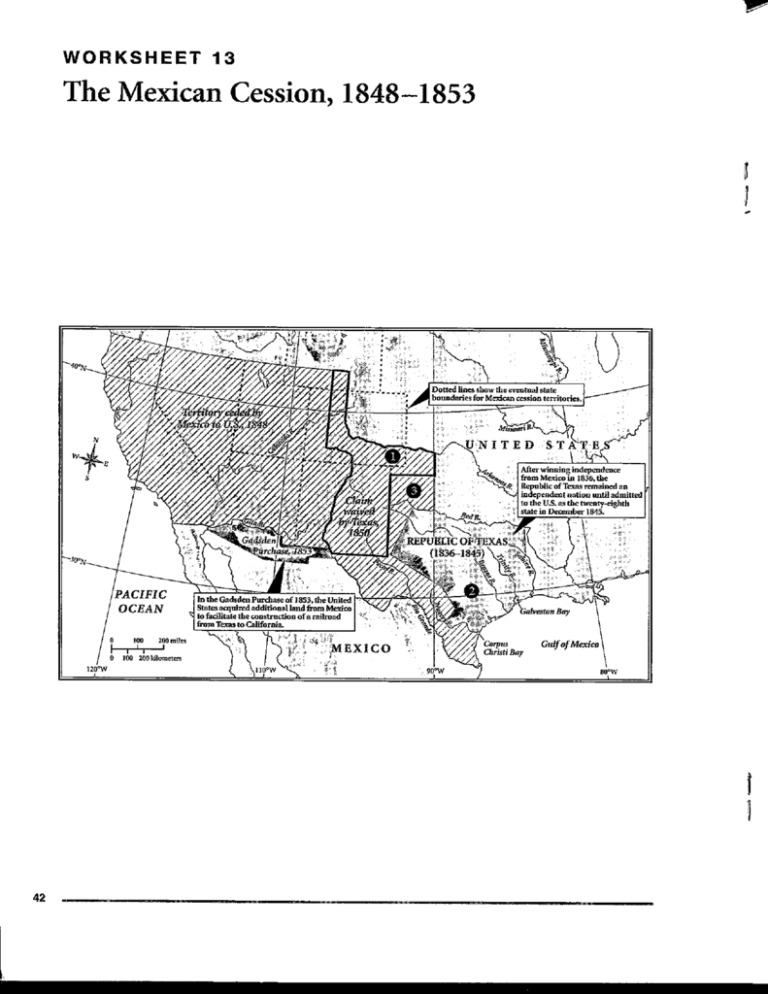
w W O R K S H E E T 13 The Mexican Cession, 1848-1853 Dotted lines show the eventual state boundaries for Mexican cession territories. NITED Alter winning independence from Mexico in 1836, the Republic of Texas remained an independent nation until admitted to the U.S. as the twenty-eighth state in December 1845. Gadsden Purchase of 1853 al land from Mexico of a railroad 42 WORKSHEET 13 . The Mexican Cession, 1848-1853 Maptalk This map shows the Republic of Texas, which became a state in 1845, and the Mexican cession territories of 1848 and 1853. This entire region is often called the American Southwest. For the Mexicans and the Americans of this period, these vast northern territories, lightly settled at the time, posed a challenge to govern because of the great distances from the central government. On maps, distances are indicated by a scale, like the one in the lower left of this map. On the projection used in this map, distance is shown in both the English and metric systems of measurement. In most map projections, the scale varies slightly from one part of the map to another. Thus the scale often represents an average or typical measure. On some maps the scale is given as a ratio or fraction, indicating the relationship between one unit on the map to the actual distance on the ground. In this particular map, the ratio is about 1:20,000,000. One inch on the map thus represents 20 million inches in reality. Reading the Map 1. There are three categories of land shown on this map. First there are the territories that in 1848 were indisputably part of the United States. Second there are the lands that remained part of Mexico after 1853. The other lands fall into a third classification: territory in dispute or which changed hands between 1848 and 1853. 2. Texas is also divided into three categories. The largest parcel (1) represents the claim that the new republic advanced in 1836. The smallest unit (2) shows the territory recognized by Mexico when Texas became part of the United States. The middle-size Texas (3) is roughly the same as today's state, its boundaries having been extended as a result of the Mexican War and then cut back as part of the Compromise of 1850. 3. The United States and Great Britain claimed the land north of the Mexican Cession of 1848 called Oregon. Both nations agreed to a policy of joint occupation in 1818. By peaceful agreement in 1846, American and Britain set the 49th parallel as the boundary between American Oregon and British Columbia. 4. Note that the dotted lines on the map show the states that were created out of former Mexican lands. Working with the Map To become familiar with the extent of the territory acquired in 1848 from Mexico in the treaty of Guadalupe-Hidalgo, label on this map all the states created from the Mexican cessions. Consult your textbook or other historical references to find the date of admission for each one, then record these dates on the map. 43 Q U I Z 13 Settlement of the Trans-Missouri West, 1835-1860 WASHINGTON TERRITORY NEW MEXICO TERRITORY PACIFIC OCEAN Choose the letter on the map that correctly identifies each of the following: 1. Mormon Trail 2. Santa Fe Trail 3. Oregon Trail 4. California Trail 5. South Pass 75
