VEST `96, Plate Tectonics
advertisement
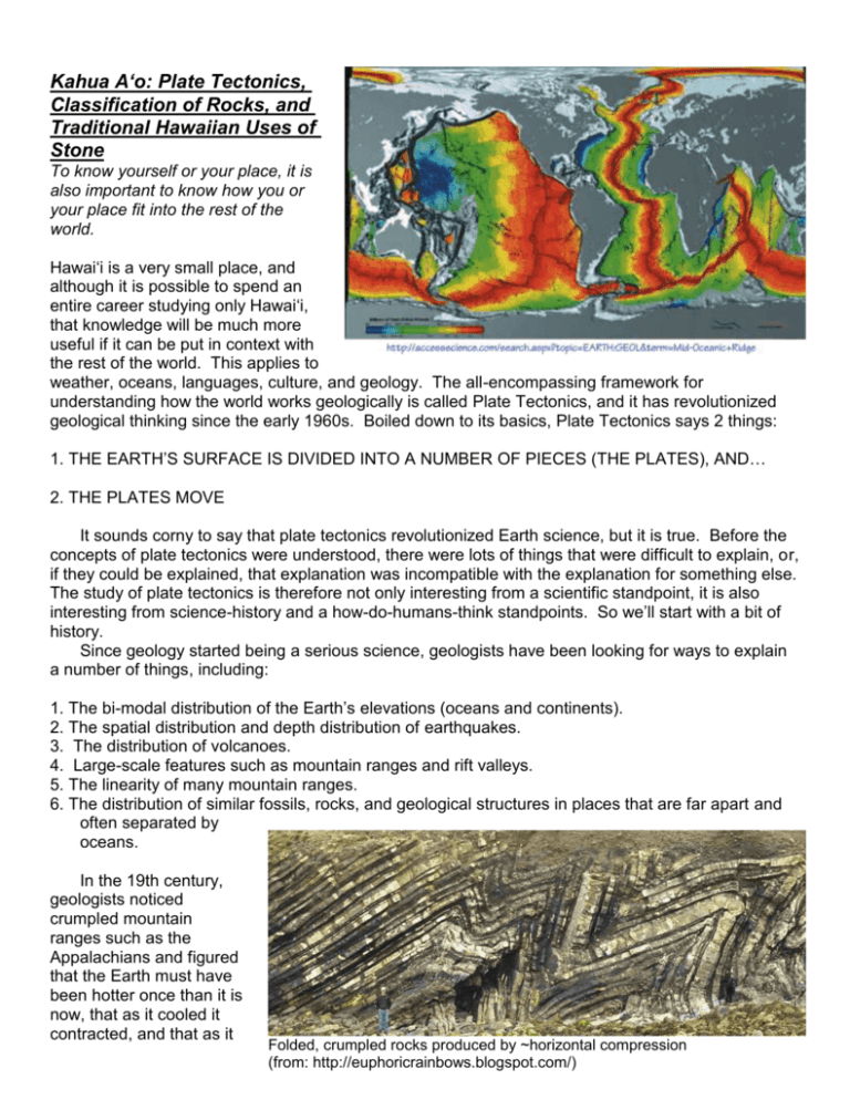
Kahua A‘o: Plate Tectonics, Classification of Rocks, and Traditional Hawaiian Uses of Stone To know yourself or your place, it is also important to know how you or your place fit into the rest of the world. Hawai‘i is a very small place, and although it is possible to spend an entire career studying only Hawai‘i, that knowledge will be much more useful if it can be put in context with the rest of the world. This applies to weather, oceans, languages, culture, and geology. The all-encompassing framework for understanding how the world works geologically is called Plate Tectonics, and it has revolutionized geological thinking since the early 1960s. Boiled down to its basics, Plate Tectonics says 2 things: 1. THE EARTH’S SURFACE IS DIVIDED INTO A NUMBER OF PIECES (THE PLATES), AND… 2. THE PLATES MOVE It sounds corny to say that plate tectonics revolutionized Earth science, but it is true. Before the concepts of plate tectonics were understood, there were lots of things that were difficult to explain, or, if they could be explained, that explanation was incompatible with the explanation for something else. The study of plate tectonics is therefore not only interesting from a scientific standpoint, it is also interesting from science-history and a how-do-humans-think standpoints. So we’ll start with a bit of history. Since geology started being a serious science, geologists have been looking for ways to explain a number of things, including: 1. The bi-modal distribution of the Earth’s elevations (oceans and continents). 2. The spatial distribution and depth distribution of earthquakes. 3. The distribution of volcanoes. 4. Large-scale features such as mountain ranges and rift valleys. 5. The linearity of many mountain ranges. 6. The distribution of similar fossils, rocks, and geological structures in places that are far apart and often separated by oceans. In the 19th century, geologists noticed crumpled mountain ranges such as the Appalachians and figured that the Earth must have been hotter once than it is now, that as it cooled it contracted, and that as it Folded, crumpled rocks produced by ~horizontal compression (from: http://euphoricrainbows.blogspot.com/) 2 contracted its outer surface got wrinkled. This turned out to be one of those explanations that did a fine job of explaining one thing, but was inconsistent with explaining something else. Specifically, if the Earth is contracting, how can there also be areas of obvious tension, such as the East African Rift and the Basin & Range in SW North America? Then, when radioactivity was discovered, geologists decided that this internal heat source meant that the Earth isn’t merely radiating away onetime-only-produced primordial heat, it is also producing heat. They calculated a cooling rate (incorrect, as it turned out) which was lower than their calculated internal heating rate. The result meant that Earth is heating up (heat gain > Death Valley, the most famous “basin” in the North American heat loss), so rather than shrinking, Basin and Range province, was (and still is) produced by maybe the Earth is actually expanding! tension. The Panamint mountains to the west (left) are being Perhaps Earth started out as all one pulled away from the Black mountains and Funeral mountains continent. As it expanded, that one to the east (right), and the block in between is dropping. The continent would have to rift apart (to valley floor consists of sediments washed in from the ranges produce rift valleys), and perhaps basalt on both sides. Collectively the structure is called a graben. could well up into the cracks (to produce the oceanic crust). This would help explain something else that people had been trying to explain, namely how the continents look like pieces of a puzzle. However, how do you explain the crumpled-up mountain ranges, which were obviously produced by collision? If everything is moving apart as the Earth expands, then nothing will ever collide, and there won’t be a reason for rocks to get crumpled. The problem, obviously, is that there are some areas that show clear evidence of previous collisions and there other areas that show clear evidence of having been pulled a part. Any explanation that produces only contraction or only expansion wasn’t going to solve the problem. Along came ALFRED VEGENER, a German meteorologist, who, in 1912, suggested that the continents drift slowly across the Earth’s surface, sometimes breaking apart, other times colliding. He called the idea Continental Drift and likened the continents to “Ships of Stone” sailing through an ocean of stone. An important aspect of his theory was that Diagrams showing how a shrinking planet could produce crumpled zones where two thick segments collide during shrinkage, or…how an expanding planet that started out as one single continent, would eventually develop multiple continents. 3 there would be both tension and compression: compression at the leading edge of a plate, tension at the trailing edge, allowing you to have both crumple zones and pull-apart zones. Wegener was mainly trying to explain the fit between South America and Africa, although he was not the first to puzzle over this: Francis Bacon noted the fit in 1620, and Antonio Snider-Pellegrini published maps in 1858 depicting formation of the Atlantic ocean as N. and S. America drifted westward away from Europe and Africa. Snider likened the process to breaking up a sheet of ice on a pond. It is important to recognize that continental drift is not exactly the same as plate tectoincs, mainly because Wegener didn’t propose a viable mechanism for how or why the continents move. In fact, that was one of a few reasons why Wegener’s proposal was met in some circles by scorn (it didn’t help that he was a meteorologist rather than a geologist). Another major problem was the fact that if continents are stone ships plowing through a stone sea, where are all the earthquakes you would expect? In what turned out to be an excellent statement of how most modern geologists envision what is going on, Arthur Holmes in 1928 said that there might be convection inside the earth and like a conveyor belt, the continents can get dragged/carried along, break up, or collide. Reproductions of Antonio Snyder-Pellegrini’s maps, published in 1858. From: http://pubs.usgs.gov/gip/dynamic/historical.html By the 1930s (Wegener died in 1930), the debate had become a stalemate with the “drifters” looking for a way to move the continents and the “anti-drifters” looking for ways to explain a whole bunch of geologic observations without moving the continents. If the drifters were correct, there were a lot of observations that could be explained: 1. The first was the fit of the continents that people had noticed for a long time. Some pieces fit together very easily, such as the east side of South America Arthur Holmes’ conceptual sketch of how convection within fitting into the west coast of Africa, the earth could produce drag on the bottom of the surface especially when you fit the continental layers, causing them to move. Reproduced from: shelves rather than the coastlines. http://www.geol.umd.edu/~jmerck/geol100/lectures/05.html Once you put these and other pieces together, you can explain a lot of additional things. 4 2. Identical LAND fossils on both sides of the Atlantic. There are fossils of animals that according to their skeletal structure don’t appear to have been swimmers, and therefore couldn’t have swum from Africa to South America. 3. Identical TREE fossils are found in many now far-flung places. Ttrees are even worse swimmers than big animals, so it is hard to explain their distribution without the continents having once been joined. The fossils of one particular tree, Glossopteris flora, can be found in India, S. America, and Australia. Interestingly, Glossopteris fossils older than ~225 million years are pretty much the same in all three places, but those that are younger than that age are more and more different the younger they are. If, prior to ~225 million years ago (a geologist would say ~225 Ma), India, S. America, and Australia were connected, it would make sense that the same trees might be found on all three continents. However, if around 225 Ma the continents started to drift apart into different latitudes, it also makes sense that the Glossopteris trees would start to evolve differently. 3. Coal forms when tropical swamps are buried and compressed by thick layers of overlying sediment, yet there are coal deposits in what are now very non-tropical places (Antarctica, N. America, Europe). If these continents were once closer to the equator where the climate is warmer, it becomes a lot easier to explain how there could have been warm swamps. 4. There is evidence that some 300 million years ago a single glacial ice sheet covered parts of S. Africa, S. America, India, and Australia. By looking at scrape marks in the rocks caused by the moving ice (called glacial striations), the directions of the ice movement can be determined. If a single ice sheet covered all these places in their present positions it would have been huge. Additionally, in their present locations, most of Africa, S. America, India, and Australia are too warm to have ever been glaciated, even during an ice age. Finally, there is no evidence that there were huge glaciers in the N. hemisphere at that time. But f all the southern continents were joined together and located at a latitude much farther south than they are today, it is much more probable that an ice sheet could have developed and it wouldn’t have to have been so huge. THEN, in the 1950s, largely as civilian extensions of military-related oceanographic work begun during World War 2, scientists started making great strides into two relativelyuncharted areas: The OCEANS and PALEOMAGNETISM (the study of the Earth’s magnetic field). Top: The southern continents in their present positions, showing the extent of ~300 million year-old glacial deposits. Bottom: Reconfiguration of the southern continents, producing a much more reasonable ice sheet Arrows indicate direction of ice motion based on glacial striations. 5 Oceanographic studies , which were started during the war in an effort to find places to look for, and/or hide, submarines, came up with the following findings: 1. There is a 65,000 km-long, 2000 kmwide, 3 km-high mountain range snaking through the central parts of most of the oceans, kind of like the stitches on a baseball. This was named the mid-ocean ridge. 2. There is a graben at the summit of this ridge indicating that it is a zone of tension. 3. Ocean sediments get thicker the farther away from the crest of the ridge you are. 4. There is a high amount of heat escaping to the surface along this ridge. The system of mid-ocean spreading centers. “Ridge” vs. “Rise” relates to the widths and steepness of the features. 5. There are lots of shallow earthquakes along this ridge. 6. There are lots of deep earthquakes along many of the oceanic margins, and this is also where one finds deep trenches. 7. Rocks dredged from the summits of the mid-ocean ridges are volcanic. 8. The oldest sediments anywhere in the oceans are only ~200 million years old. Diagram showing how there is a tensional graben at the axis of all mid-ocean ridges, and how sediments are thin at the edge of the graben and get thicker the farther you are form the axis. 9. There are areas of anomalously high gravity over the ridges and of anomalously low gravity over the trenches. Paleomagnetic studies came up with very useful discoveries as well. Rocks have weak magnetic fields. When a volcanic rock containing the mineral magnetite cools, the magnetic field of all the magnetite grains line up in a direction parallel to the direction of the Earth’s magnetic field. Note that the temperature at which all the fields line up (the Curie temperature or Blocking temperature) is well below the temperature at which the rock has solidified, so it is not correct to think of the magnetite grains as little magnets in molten lava. This process, called Thermal Remnant Magnetism (TRM) is important because it means that a stack of rocks, accumulated over time, acts like a tape recorder showing the direction from the rocks in each layer to the magnetic pole. 6 Let’s say you go to a place and measure the orientation of a rocks’ magnetic field and find that it is different from what you measure with a compass. Either the magnetic poles have moved relative to the rock, or the rock has moved relative to the magnetic poles. Or both. How do you decide which happened? Plot the apparent pole positions of two different continents through time. If the two 40 million year-old directions point to the same place, and the two 30 million year-old directions point to the same place, and so on, then the pole has been moving and the continents have remained fixed. If the directions for each age point to different locations, as if the pole was in different places at the same time (which isn’t possible), then you know that it was the plates that have moved. The magnetic field does drift around a little (called secular variation), but most of what is sometimes called “apparent polar wander” is actually due to the continents moving, not the magnetic poles. The major oceanographic paleomagnetic discovery had to do with measurements of the magnetic field intensity rather than direction. Sensitive magnetometers were developed during WW II for the purpose of detecting enemy submarines. These magnetometers were sensitive enough to also detect the magnetic field intensities of the ocean floor, and the results were quite striking. A magnetometer measures the entire magnetic field that it is experiencing, and it is to determine if that field is from one or more magnetic sources. Therefore if two magnetic fields happen to be aligned with one another, the combined magnetic field will be strong. On the other hand, if the two fields are aligned in opposite directions from each other, the combined field will be weak. When these magnetometers were driven back and forth across mid-ocean ridges, the data showed three unexpected things: 1) a pattern of roughly parallel (to the axis of the ridge) stripes of strong and weak magnetic fields; 2) the stripes are symmetrical across the ridge; and 3) the stripe down the middle always indicated a strong field. What was this showing? When the measurement took place at a location where the magnetic field of the ocean-floor rocks was aligned in the same direction as the magnetic field of the Earth, the two fields combined to produce a strong signal. When the measurement was made where the magnetic field of the rocks was oriented in an opposite direction to that of the Earth, the two partially canceled each other, and the result was a weak Diagrams showing the different results for true polar wander vs. apparent polar wander (caused by plate wander). 7 signal. Geophysicists knew already that the Earth’s magnetic field had reversed its self (essentially flipped 180º) multiple times in the geologic past, but never before had they realized that there was a record of this in the ocean floor. Why are the stripes parallel, and why are they symmetric across the axes of the mid-ocean ridges? As we noted above, igneous rocks adopt a magnetic field orientation parallel to the Earth’s magnetic field at the time that they cool below their Curie temperature. The fact that there are symmetric stripes means that the rocks are erupting at the ridge axis and they split apart and move away from each other. The axis of a ridge shows a strong magnetic signal because these are young lavas that erupted during recent times, when the Earth’s magnetic field has been the same as it is today. We refer to this orientation of the magnetic field as Normal magnetic polarity, and one would say that the associated rocks have a normal magnetic orientation. On either side of the central band of strong-signal rocks is a band of weak-signal rocks. These erupted during the most recent time when Earth’s magnetic field was reversed from what it is today. We refer to this orientation of the Earth’s magnetic field as Reversed magnetic polarity, and one would say that the associated rocks have a reversed magnetic orientation. The fact that the two bands of reversed-polarity rocks are separated from each other is very strong evidence that they have moved apart. Farther from the ridge in both directions are two bands of strong-signal rocks (i.e., they have a normal magnetic polarity). They were erupted even longer ago, during the previous normal magnetic time. FINALLY FIGURING IT OUT In 1962, Harry Hess, an oceanographer who had helped collect Diagram showing the symmetric pattern of magnetization much of the new oceanographic data, across the axis of a mid-ocean ridge proposed SEA FLOOR SPREADING. He was aware that his idea was going to be a surprise to many, and therefore subtitled his paper “An Essay on Geo-poetry”. Sea floor spreading says that magma rises from depth beneath a mid-ocean ridge and pushes its way to the surface. In so doing it pushes the existing rocks to the side. The next batch of magma then pushes itself to the surface, and so on. This would mean that the farther you were away from the ridge crest, the older the crust would be and the longer it would have had to sit around and collect sediments. One problem with this idea is that if the plates are pushed apart, there should be indications of compression acting on the two plates. Instead, there is evidence of just the opposite, namely tension, indicated by the graben running along the crest of every mid-ocean ridge. Never the less, the basic idea, that the ocean floor consists of young lavas that are created at mid-ocean ridges, is now a basic tenet of plate tectonics. J. Tuzo Wilson suggested that one way to possibly test the idea that the ocean floor is moving away from spreading centers would be to find a longlived magma source that didn’t move (maybe because it was below the moving plates), but produced volcanic islands high enough to break sea level. Then, as The concept of a stationary “hotspot” producing a chain of volcanoes that are older in the “downstream” direction. 8 the crust moves over this stationary magma source, a linear chain of volcanoes will be produced. These volcanoes will be young at the “upstream” end and old at the “downstream” end. Such an unmoving magma source is now called a “hotspot” although “hot column” would probably be more appropriate. Pretty obviously Wilson was thinking about Hawai‘i when he made his suggestion. Vine, Matthews, and Morley said that the lava that is erupted at a mid-ocean ridge is displaying TRM, and is indeed recording past magnetic directions (just like the on-land rocks). The ages of the various magnetic reversals (the magnetic time scale) were known from on-land studies and thus you should be able to figure out the ages of the oceanic crust rocks using this sideways version of the magnetic time scale. THEN...knowing the ages and the distance from the ridge crest, you could figure out the spreading RATE. People did this exercise, and it turns out that there are variable spreading rates. The East Pacific Rise (EPR), which is producing the Pacific plate, is spreading at 16-22 cm/year. This is what is called the “full spreading rate”, meaning that if you were standing on one side of the EPR, it would appear that the other side was moving away from you at 16-22 cm/year. The velocity of one plate, the half-spreading rate would be half of the full spreading rate, namely 8-11 cm/year. The EPR is has the highest spreading rates of all mid-ocean ridges. The spreading rates are easy to determine from the ages of rocks (determined via paleomagnetism or by dating fossils in sediments on the plate), and comparing the ages to the distances from the mid-ocean ridge crest. However, this does not determine the absolute motion of either plate of a spreading system if the mid-ocean ridge itself is also moving. The problem is to find something that isn’t moving so that you can have an absolute reference point. An analogy would be a bunch of people floating around in the ocean on rafts out of sight of the coast and trying to decide who is moving, who is stationary, etc. Any two raft-floaters could figure out how fast they are moving toward or away from each other, but whether one was stationary and the other moving, or both were moving would be impossible without a fixed reference point. For a long time, hotspots such as that which feeds Hawai‘i’s volcanoes, have been considered “fixed”, meaning they don’t move relative to the center of the Earth nor to each other. They therefore have been used as a reference frame against which to determine the absolute motion of the plates. Some recent evidence, however, is starting to cast some doubt on whether hotspots really are fixed for ever. Most geophysicists still think that if hotspots do move, they move much more slowly than plates move. Spreading centers only explain how plates are created. We know that the Earth isn’t expanding, so what compensates for the creation of new plate material at mid-ocean ridges (and at continental rifts)? For a long time it had been recognized that earthquakes are not scattered randomly over the globe. Instead, there are places on Earth where earthquakes are very common and other places where they almost never occur. One such type of place where earthquakes are common is the edges of some oceans, for example along the western edge of South America. Additionally, at these places, seismologists had noted that the farther you were from the ocean, the deeper the earthquakes got. For example, there are shallow earthquakes just offshore of the W coast of S. America. As you move East (i.e., inland), the earthquakes get deeper. These sloping bands of earthquakes were known as “Wadati-Benioff zones”, after Kiyoo Wadati and Hugo Benioff, the seismologists who first described them, but prior to the early 1960s they hadn’t been explained. Not long after Harry Hess’ seafloor spreading idea for producing oceanic lithosphere came along, people started looking for ways to get rid of oceanic plates because we know that the Earth is not getting bigger. One idea to “consume” oceanic plates and simultaneously explain the Wadati-Benioff zones is that of “subduction zones” and they are accepted today as an integral part of plate tectonics. 9 The dipping zones of earthquakes are essentially traces of the down-going plates, although in detail the position of the earthquakes is not consistent within the plate. Specifically, the shallow earthquakes are near the boundary between the two plates, where they are scraping past each other. Deeper earthquakes, however, occur in the middle of the downgoing plate. With all these new ideas and concepts in mind, Hess and Wilson figured out all the plate boundaries in general (except in the SW Pacific), the types of boundaries (except in the SW Pacific), and what happens at each (except in the SW Pacific). By the late 1960s, geology textbooks had to start being rewritten. WHAT REALLY MOVES?? The cool, rigid, brittle LITHOSPHERE. WHAT DOES IT MOVE ON?? The weak, mushy ASTHENOSPHERE. This explains how movement can take place without having to generate earthquakes (other than at plate boundaries). This was the mechanism that eluded Wegener and made his farsighted idea difficult to swallow at the time. The plates themselves are rigid - gentle warping is possible in the interiors and intense deformation takes place only at the boundaries with other plates. Cross-section of Sough America showing the locations of ~50 years of earthquakes (magnitude and depth legend at right). Note that shallow earthquakes (red-brown) cluster along the W. coast, and as one moves east, the earthquakes become deeper (blue to green to yellow). The map part represents the type of data that Wadati and Benioff had recognized, but not explained. In the cross section at the bottom, the plates have been added to illustrate a plate tectonic concept, namely a subduction zone. Note that in the shallower part of the subduction zone the earthquakes are at the top of the downgoing plate, and are due to binding between the downgoing and overlying plate. Deeper earthquakes, however, are within the downgoing plate. These diagrams were produced with a freeware program called Seisvole: http://bingweb.binghamton.edu/~ajones/SeismicEruptionSetup.exe 10 WHAT CAUSES THE PLATES TO MOVE?? There are 4 ideas that have been proposed. The third is the most plausible, although the answer may include some contribution from one or two others: 1. “ridge-push” The plates are pushed apart by magma pressure at Diagram showing the details of earthquake location at a subduction zone. mid-ocean ridges. This Stars are earthquake locations and colors indicate the relative temperatures of is the original idea of the rock (red = hottest, purple = coolest). Shallow earthquakes take place near Harry Hess, but the big the plate-plate contact and are due to friction between the two plates. Deeper problem with this idea is earthquakes are within the middle of the downgoing plate, and are due to that the ridges bending and unbending stresses. Note that earthquakes only occur within the cooler parts of the plate, and for this reason, none are deeper than ~700 km. themselves appear to be zones of tension, not compression. Another problem is that compared to their lengths and widths, the plates are very very thin. It is difficult to imagine that compressive forces could act across such wide, long, but think plates without causing them to buckle. 2. “trench-pull” Once the leading edge of a plate is pushed under at a subduction zone, gravity will pull it under and the rest of the plate will move along with it. This idea also suffers from the thinplate problem, namely it is hard to imagine how the plate could transfer the tensional stress across its length and width without pulling apart. 3. “drag” Convective motion of the underlying asthenosphere drags the plates along. The beauty of this idea is that it overcomes the thin-plate problem. It also explains why the crests of mid-ocean ridges are zones of tension – if two convective cells are moving in opposite directions, they will pull their overlying plates apart. This would provide the perfect scenario for mantle rock to well up to take its place, melt a little bit, and thereby provide material to build new oceanic lithosphere. 4. “sliding downhill” There is a little bit of mantle-upwelling at mid-ocean ridges so it is “downhill” away from them. Calculations show that only a 1:3000 slope is required. This idea also doesn’t have the thin-plate problem because gravity would work along the entire area of the plate, not just one edge. The map on the next page is somewhat simplified, but more or less correct. The one place where nobody seems to agree about what is happening is the SW pacific, and the authors of this map have essentially decided not to wade into the controversy. One thing that should jump out at you is the fact that plate boundaries are not necessarily the same as continent boundaries. This is one of the key differences between the theory of plate tectonics and the theory of continental drift. The theory of continental drift is largely considered to be obsolete, and should be dealt with only in a historical context. Most plates are partly oceanic and partly continental. Good examples are South America and Africa. A few plates are wholly oceanic (e.g., Cocos) or largely oceanic (e.g. Pacific). Only the Arabian plate can be considered to be mostly continental. These boundaries help to emphasize the idea that the plates are not crustal plates. If they were, you wouldn’t have continent and ocean being 11 part of the same plate because continental crust and oceanic crust are different. Instead, plates are lithospheric plates. This means they consist of crust plus the upper part of the mantle. STRUCTURE OF THE EARTH, LAYERS, ENERGY SOURCES, ETC. Most everyone knows that the Earth can be divided into layers, sort of like a great big onion, but there is some confusion about the different ways this can be done, and even professional geologists are sometimes sloppy about what it is they are actually talking about. The ways that the layers are defined are: 1) by their chemical properties; and 2) by their physical properties. Both schemes are equally valid, but if the terms are used carelessly (which is often the case), things can get confusing. Neither of the schemes for describing the Earth’s layers is better than the other – which one you use depends on what you are trying to discuss. An analogy might be a classroom. The teacher can divide the students by gender, hair color, age, hometown, etc. All of these classifications will operate on the same set of students, and none are inherently better than the others. 12 THE CHEMICAL LAYERS (Crust, Mantle, Core) THE CRUST: comes in 2 flavors, continental and oceanic. Continental crust is thick (30-60 km), has a lower density (about 2000 kg/m3), and is rich in minerals that are silicates of aluminum, calcium, potassium, and sodium, such as feldspars and quartz. Many intro-geology textbooks say that the average composition of the continental crust is granodiorite (a rock sort of like granite), but this often confuses students into thinking that the continental crust is granodiorite. It is probably better to say that continental crust is very diverse and includes pretty much every rock type that exists, from basalt to granite to limestone to sandstone to metamorphic rocks, and so on. Oceanic crust is thin (2-5 km), has a higher density (about 2500 kg/m3), and is rich in minerals that are silicates of magnesium and iron, such as olivine and pyroxene. The average composition of oceanic crust is basalt. Unlike the granodiorite business for the continental crust, a simple compositional designation for the oceanic crust is valid because much of the oceanic crust really is basalt or its intrusive equivalent, gabbro. THE MANTLE: The mantle has a higher density than the crust (about 3300 kg/m3), and is composed mostly of olivine and pyroxene (or their high-pressure equivalents). A rock consisting of olivine and pyroxene is called peridotite. No drill holes have ever reached the mantle, although people have tried. There are a few slivers of the uppermost mantle that have been slapped up onto the surface where plate collisions occurred and thereby exposed on the surface. Such rocks are called ophiolites. Additionally, some volcanoes occasionally bring up pieces of the mantle as inclusions in their erupting magma. Such inclusions, whether they come from the mantle or crust, are called xenoliths (foreign rocks). Most of what we think we know about the mantle comes from indirect study (earthquakes). A very prominent change in the propagation speed of earthquake waves (from slower to faster) called the Mohorovicic Discontinuity (usually called the Moho) defines the crustmantle boundary. THE CORE: The core is the densest layer, and it consists of an iron-nickel alloy, perhaps with a little bit of sulfur mixed in. We cannot sample it, and no magma sources are that deep (so no volcanoes bring up core xenoliths), so all evidence is indirect (that movie from a few years ago was not a documentary): 1. Many meteorites consist of iron-nickel alloys. Most meteorites are thought to be fragments of a broken-up planet that was once like Earth. We don’t find lumps of iron-nickel alloy lying around on the Earth’s surface so if Earth is indeed like that broken-up planet, our Fe and Ni must be down in the core. Additionally, we generally know the elemental abundance of the inner solar system, and because the crust and mantle combined do not contain sufficient Fe to match the solar system abundance, Earth’s Fe and Ni must be in the core. 2. From studies of orbital mechanics involving the moon and sun we know that the average density of the Earth is about 5500 kg/m 3. Crust and mantle rocks are both less dense than this so there must be something denser to make up the difference: 13 densities of... whole Earth = 5500 kg/m3 crust = 2000-2500 kg/m3 mantle = 3000-3500 kg/m3 FeNi meteorites = 7000 kg/m3 but under core pressures = 10,000-12,000 kg/m3 People sometimes wonder why mantle convection can’t drag up pieces of the core from the coremantle boundary. What they don’t realize is that the density difference between the core and mantle is 3x greater than the density difference between the crust and atmosphere. How often does convection in the atmosphere drag up pieces of the crust? The Earth is therefore chemically zoned. 90% of the whole Earth is Fe, O, Si, and Mg, but 90% of the crust is O, Si, Al, and Fe. The elements get separated into layers, but not merely by their atomic weights. This is because they exist as compounds (minerals), and it is the chemical affinities of these minerals and their densities that determine the layers. For example, uranium, lead, and thorium, which are dense elements, readily form low-density compounds with oxygen and are thus concentrated in the continental crust. THE PHYSICAL LAYERS Based on evidence from earthquakes, gravity surveys, and lab experiments, we can also divide the Earth into physical layers: THE LITHOSPHERE: “rock layer”: This layer includes the crust and the uppermost mantle. It is cold, rigid, and brittle (it acts like rock, hence the name). It extends down to about 100 km. The “plates” of plate tectonics are pieces of lithosphere. Therefore we should avoid the term “crustal plates”, and instead use “lithospheric plates”. THE ASTHENOSPHERE: “weak layer”: This layer is part of the upper mantle. Although solid, is hot, weak, and ductile (able to deform). Deformation of the asthenosphere allows the tectonic plates to move. Partial melting of the asthenosphere produces magma which erupts at volcanoes, but it is important to remember that the great majority of the asthenosphere is solid. THE MESOSPHERE: “middle layer” This is most of the mantle. It is hotter than the asthenosphere, but because the pressure is higher, it is a much less ductile solid. Despite being a solid, however, the mesosphere can indeed flow, and it is this flow, driven by thermal buoyancy, which drives plate tectonics. THE OUTER CORE: Seismic evidence shows that this layer of iron-nickel alloy is liquid. Thermal convection and rotation of the Earth cause the outer core to move. It is therefore a moving electrical conductor, and this movement produces a magnetic field, namely the Earth’s magnetic field. THE INNER CORE: This layer is also iron-nickel alloy, and although even hotter than the outer core, the high pressure keeps it solid. This solid-liquid business often confuses people. Why would the inner core, at a temperature of ~5000° C, or the lower mantle, at a temperature of ~3500 °C not be molten? After all, the hottest magmas that erupt are “only” about 1200 °C. The answer is that the pressure at these depths prevents melting. Everywhere within the Earth there is a constant battle between high temperature, 14 which tries to melt rocks and minerals, and high pressure, which tries to keep them together. In only a very few locations, such as the outer core and a few very specific parts of the upper mantle, does temperature win out so that liquid can exist. Everywhere else, pressure wins out and the rocks are solid. WHERE DOES THE HEAT COME FROM? Topic Earth in the Solar System Benchmark SC.ES.8.8 Describe the major internal and external sources of energy on Earth (look, Pauline, a standard!!) Where is all this heat coming from??? What drives plate tectonics? Where does the heat for producing magma come from? The two main sources of heat are decay of naturally-occurring radioactive elements, and heat left over from Earth’s formation. There is not a lot of radioactive material within the Earth, and Earth formed a heck of a long time ago (4.6 billion years), however, rock is a very good insulator so both primordial heat and heat being generated today are retained very well. A tiny amount of heat energy comes from meteorites striking the Earth, but it is so tiny that it can be ignored. The distribution of the heat is such that it is hotter in the middle than on the surface. Just like a pot of soup on the stove, hot material below and cooler material above sets up convection. The base of the mantle is hotter because the core beneath it is hot. Hot mantle rises at what we call hotspots, flows laterally, dragging against the bases of the plates and causing them to move, and then descends at subduction zones. WHAT ARE PLATE MARGINS LIKE AND WHAT DO THEY HAVE TO DO WITH VOLCANOES? There are 3 types of plate margins: divergent, convergent, and transform. 1. DIVERGENT MARGINS. Here new lithosphere is being formed. Most divergent margins are oceanic (= mid-ocean ridges) but there are also continental rifts, the most famous of which is the East African Rift. Most likely all the present oceans started out as continental rifts at one time. Divergent margins are characterized by tensional forces - graben, rift valleys, and normal faults are common. Most geologists consider divergent margins to be the consequence of plates being pulled apart rather than the cause of plates being pushed apart. Here the new lithosphere is thin and hot, making it ductile; large stresses cannot build up so earthquakes, although common, are shallow and not very big. So what happens when two lithospheric plates are pulled apart? The Earth cannot tolerate a huge crack in its surface, so asthenosphere from below flows upward to take its place. This flow occurs almost wholly in the solid state, so it is therefore very slow. However, some of that asthenosphere rises fast enough so that the pressure-temperature balance that has kept it solid (despite being hot) is upset in favor of temperature; the rock starts to melt a little bit. Once magma (molten rock) is produced, it very easily migrates to the surface. This is because it is buoyant and mobile. It probably starts as tiny films between mineral grains which coalesce into tiny blebs and which eventually coalesce into decent-sized blobs of magma that eventually make it all the way to the surface. At a mid-ocean ridge, the magma migrates to the surface as blade-shaped dikes, and some magma solidifies in these blade-shaped conduits. A cross-section of an oceanic plate therefore has sediment on top, lavas below this, dikes below the lava, and gabbro (basaltic magma that solidified very slowly) below the dikes. 15 The shape of a mid-ocean ridge depends on the spreading rate. A high spreading rate, such as at the East Pacific Rise, is associated with high magma supply from depth. This rapid upwelling partially balances the subsidence that takes place as the two plates pull apart. On the other hand, if the supply rate is low, there is ample chance for collapse along the summit of the spreading ridge to take place; this collapse is much less balanced by by low supply rates, leading to impressive, well-formed axial graben. Volcanic activity is almost always basaltic. The most common volcanic rock on Earth is Mid Ocean Ridge Basalt, also known as MORB. MORB has an Figure 7. Diagrams showing the different profiles of fast and slow extremely monotonous spreading ridges. composition and only geochemists and petrologists get very excited about it. Importantly, geochemistry has shown that MORB derives from very shallow mantle. This suggests that the upwelling at mid-ocean ridges does not involve material moving up from great depths. If the entire mantle is convecting (which seems likely) then the upwelling at mid-ocean ridges is a consequence of plate tectonics, not a driving force. 2. CONVERGENT MARGINS. Here old lithosphere is consumed and/or mountain ranges are built. The exact nature of a convergent margin depends on what is colliding with what. A) When two continental plates collide, because both are thick and buoyant, neither wants to dive under the other. Instead the just crumple up, producing compressional mountain ranges. The most obvious present example of this is the collision of the Indian continental plate against the southern margin of the Eurasian continental plate, forming the Himalayan mountains. Many other mountain ranges, including the Appalacians, Rockies, Alps, Urals, etc. are the result of continent-continent collisions in the geologic past. There are lots of big earthquakes associated with these continent-continent collisions, but there is no volcanism. B) Whenever oceanic lithosphere is involved a convergent margin will consist of a subduction zone. There are ocean-ocean subduction zones where one oceanic plate dives under another and there are ocean-continent subduction zones where an oceanic plate dives under a continental plate. The oceanic plate always does the diving because it is thinner and denser. Volcanism is very intimately associated with subduction zones. Features of subduction zones include: 1. Andesitic “arc” volcanism 2. high-pressure, low-temperature metamorphism 3. deep, large-magnitude earthquakes 4. a deep trench, sometimes filled with sediments 5. chaotic “melange” of rocks 16 The volcanism does not come from friction of the two plates rubbing together. It is a little more complicated. The down-going plate includes oceanic lithosphere created at a spreading center plus all the wet ocean-floor sediments that have accumulated. Those sediments that are not scraped off at the trench get subducted and along with the plate they heat up as they get deeper. Pretty soon the water is driven out of the sediments by the heat. This water (and other fluids) migrates upward into the wedge of mantle between the downgoing plate and the overriding plate. The melting point of rocks can be lowered - sometimes considerably - by the addition of water, and sure enough the water driven off the downgoing plate causes melting of the mantle wedge. This melt migrates to the surface to erupt at volcanoes. Subduction-related volcanoes form lines parallel to the plate boundaries and 150-300 km “inland” from the actual boundary. The actual boundary is the deep trench. The volcanoes form “arcs” because of the relationship between a downgoing plate and the curved Earth. If the dip is shallow, the curvature is strong (it has a small radius), and if the dip is steep the curvature is less pronounced (a large radius). A vertical dip would give a straight line of volcanoes. The relationship is as follows: -young subducting plate, small , small radius -old subducting plate, large , large radius This points out the importance of density differences between the subducting plate and the mantle into which it is subducting, and also shows that “trench pull”, although it may not be actually driving the plate motion, cannot be ignored altogether. Calculations show that the lithosphere loses its brittle properties (its ability to break and thus generate earthquakes) by the time it has subducted to about 700 km blow the surface. That is why there are no earthquakes deeper than this. Until the advent of seismic tomography, 700 km was therefore the deepest we could “see” the downgoing plates. Tomography looks at the attenuation or accentuation of seismic waves as they pass through the Earth - hot places attenuate seismic waves, cool places speed them up. Even though below 700 km, downgoing plates can’t generate earthquakes, they are still different (cooler) than the surrounding mantle and tomography can “see” them down to about 1400 km. 3. TRANSFORM MARGINS. Transform margins are those where two plates are moving past each other. The most common are found at transform faults near mid-ocean spreading centers. The spreading centers can’t bend very well so to turn corners, segments of offset are needed. Between two segments of spreading the two pieces of plate are moving in opposite directions and strike-slip motion is taking place. Earthquakes here are relatively shallow and small. Outside the two spreading segments the plates are moving in the same direction, never-the-less there is still a scar left over from earlier, and these “fracture zones” are weaknesses that remain in the plate. They help to explain some of the non-volcanic earthquakes that we sometimes have here in Hawai‘i. There are also continent-continent transform margins and the most famous of these is the San Andreas fault (which is actually a system of many faults). The Pacific plate is almost all ocean but it carries a small sliver of continental crust. This sliver is rubbing against the N. American plate (all continent) at a transform fault. Earthquakes are not very deep, but they can be pretty large. Some parts of the fault system are tightly locked; earthquakes are infrequent but very large. Other parts are poorly locked; earthquakes are frequent (almost regular), but not very large. Still other places are not locked at all and constant creep occurs rather than earthquakes. 17 Los Angeles is on the Pacific plate, which is moving to the NNW. In perhaps 60 million years L.A. will have moved up past San Francisco, most of which sits on the N. American plate. L.A. may be an offshore island but it will not fall into the sea! Figure 2. The compositional (left) and physical (right) layers of the Earth. 18 19

