Changes
advertisement
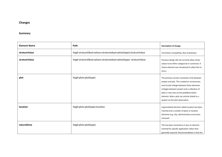
Changes Summary Element Name Path Description of change stratumValue VegX:stratumObservations:stratumobservation(type):stratumValue Corrected a misspelling. Was strataValue stratumValue VegX:stratumObservations:stratumobservation(type): stratumValue Previous design did not correctly allow strata values to be either categorical or numerical. A choice element was introduced to allow this to occur. plot VegX:plots:plot(type) The previous version contained a link between project and plot. This created an unnecessary and circular linkage between these elements. Linkages between project and a collection of plots is now only via the plotObservation element. Note a plot can only be linked to a project via the plot observation. location VegX:plots:plot(type):location A generalised element called Location has been inserted and a number of place or location elements (e.g. city, administrative area) were removed. naturalArea VegX:plots:plot(type): This has been removed as it was an element inserted for specific application rather than generally required. Recommendation is that the userDefined element be used for such entities. slopeAspect VegX:plots:plot(type):slopeAspect Aspect of slope can now be record as either a categorical or numerical value. geologicalEra VegX:plots:plot(type): This has been removed as it was an element inserted for specific application rather than generally required. Recommendation is that the userDefined element be used for such entities. Plot(attribute)ID VegX:plots:plot(type):(attribute)ID This has been removed since only plotUniqueIdentifier should be used to uniquely define a plot. Units of measure In all cases where a numerical value can be recorded, additional elements have been attached to allow the units, accuracy and method to be captured. noteType This has been added to all note elements to improve details captured of the origins etc of a note. ObservationType VegX:plotObservations(type) This element/type has received significant reorganisation. Many elements were originally placed here from other schemas/data models and this re-organisation improved readability. New groups follow: observationType:taxonomicQuality VegX:plotObservations(type) observationType:landUse VegX:plotObservations(type) observationType:surfaceCover VegX:plotObservations(type) observationType:vegetationCover VegX:plotObservations(type) observationType:vegetationStructure VegX:plotObservations(type) observationType:referencePublication VegX:plotObservations(type) observationType:hydrology VegX:plotObservations(type) observationType:soil VegX:plotObservations(type) observationType:biotope VegX:plotObservations(type) observationType:observationConditions VegX:plotObservations(type) observationType:legalProtection VegX:plotObservations(type) aggregateValue VegX: aggregateOrganismObservation(type):aggregateValue Previous design did not correctly allow aggregateValues to be either categorical or numerical. A choice element was introduced to allow this to occur. In addition, an Optional height at which the aggregated observation was made was added. For example, aggregated percentage cover, of taxa, at a specific height. The height can either be a specific measure, e.g. in meters or a defined stratum within the plot. relatedSpatialItem VegX:plots:plot(type): relatedSpatialItem This element was removed from the plot element. It did not intuitively allow for the position of an individual item to be recorded against a plot. It makes more sense if the measurement is associated with an observation event. Therefore the relative coordinate/position of an item is now recorded VegX:individualOrganismObservation relatedItem (individual items) Name change. relatedItem becomes relatedIndividual. Attribute: ordinal and qualitative VegX:attributes:attribute:ordinal These elements were incorrectly set as unbounded. taxonNameUsageConceptID:individual organism VegX: taxonDeterminations: taxonDetermination:taxonNameUsageConceptID Corrected a misspelling coverTypeAttributeID VegX:plotObservations:plotObservation:vegetationCover:cover: coverTypeAttributeID Correctly named this element as an attributeID VegX:stratumObservations:stratumobservation(type):stratumValue Corrected a misspelling stratumValue reference element. Details strataValue Schema path: VegX:stratumObservations:stratumobservation(type):strataValue Status: Changed Description: A strata value may either be a categorical or numerical. Categorical values link to an attributeID where the category is defined. Numerical values can be further defined uppervalue, accuracy etc. Change: Previous design did not correctly allow strata values to be either categorical or numerical. A choice element was introduced to allow this to occur. plot Schema path: VegX:plots:plot(type) Status: Changed Description of element: Sampling locations represented as one or more points, lines, polygons, or volumes, and is the basis for experimentation or measurement. Its properties are assumed to be constant over time. Change: The previous version contained a link between project and plot. This created an unnecessary and circular linkage between these elements. Linkages between project and a collection of plots is now only via the plotObservation element. That is: The individual project is defined within the element veg:projects which is a container for all projects within the dataset. Note a plot can only be linked to a project via the plot observation. location Schema path: VegX:plots:plot(type):location Status: new Description of element: A collection of named places or geographic regions. Includes elements to indicate what type of place and which place/geo-region schema it was from. Change: a generalised element called Location has been inserted and a number of place or location elements (e.g. city, administrative area) were removed. naturalArea Schema path: VegX:plots:plot(type): Status: removed Description of element: Change: this has been removed as it was an element inserted for specific application rather than generally required. Recommendation is that the userDefined element be used for such entities. slopeAspect Schema path: VegX:plots:plot(type):slopeAspect Status: changed Description of element: Slope value may either be a categorical or numerical. Cardinal values link to an attributeID where the category is defined. Numerical values can be further defined uppervalue, accuracy etc. Change: aspect of slope can now be record as wither a categorical or numerical value geologicalEra Schema path: VegX:plots:plot(type): Status: removed Description of element: Change: this has been removed as it was an element inserted for specific application rather than generally required. Recommendation is that the userDefined element be used for such entities. Plot(attribute)ID Schema path: VegX:plots:plot(type):(attribute)ID Status: removed Description of element: Change: this has been removed since only plotUniqueIdentifier should be used ot uniquely define a plot. Units of measure In all cases where a numerical value can be recorded, additional elements have been attached to allow the units, accuracy and method to be captured. See MeasurementType noteType Schema path: noteType Status: new Description of element: Complex type for specifying additional comments or explanations pertaining to the element of concern Change: this has been added to all note elements to improve details captured of the origins etc of a note. ObservationType Schema path: VegX:plotObservations(type) Status: changed Description of element: Observations made on a single plot and during a single date-time period. This allows all time dependent parameters to be grouped. Change: This element/type has received significant reorganisation. Many elements were originally placed here from tother schemas/data models and this organisation improved readability. New groups follow: observationType:taxonomicQuality: Subjective assessment of the taxonomic quality on the plot. observationType:landUse: e.g. Agricultural types. observationType:surfaceCover: Percent of surface covered for different surface categories, e.g. water, litter exposed bedrock, bare soil, gravel etc. observationType:vegetationCover: Percent of total covered for different vegetation categories observed on the plot, e.g. tree, shrub, field layer (Herb stratum), non-vascular layer, floating and submerged cover (wetlands) etc. observationType:vegetationStructure: Height of vegetation components observed on the plot, e.g. tree, shrub, field layer (Herb stratum) etc. observationType:referencePublication: Reference to an original publication and additionally a table or section within a publication. observationType:hydrology: What is the hydrologic regime, which is a reflection of frequency and duration of flooding? Distance from surface to ground water. Usually recorded in meters. observationType:soil: Specific soil attributes (e.g., A specific soil name.). observationType:biotope: A specific biotope type that existing during this plot observation. observationType:observationConditions: Conditions at the time of observation. Weather, temperature etc observationType:legalProtection: A code for legal protection status of the plot during the plot observation. Recommended that this is from a closed list of legal protection status types. This will vary depending on region. aggregateValue Schema path: VegX: aggregateOrganismObservation(type):aggregateValue Status: changed Description of element: An assessment of the overall occurrence of an organism in a Plot. It may consist in a quantitative value (e.g. total basal area), or an ordinal scale value (e.g. cover class value). Optionally the height of the measure can also be recorded. Change: Previous design did not correctly allow aggregateValues to be either categorical or numerical. A choice element was introduced to allow this to occur. In addition, an Optional height at which the aggregated observation was made. For example, the aggregated percentage cover of taxa at a specific height. The height can either be a specific measure, e.g. in meters or a defined stratum within the plot.

