2 - Ministry of Development of North Eastern Region, North East India
advertisement
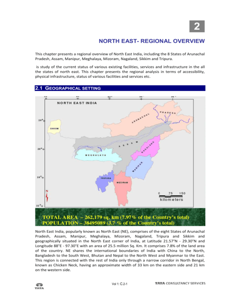
2 NORTH EAST- REGIONAL OVERVIEW This chapter presents a regional overview of North East India, including the 8 States of Arunachal Pradesh, Assam, Manipur, Meghalaya, Mizoram, Nagaland, Sikkim and Tripura. is study of the current status of various existing facilities, services and infrastructure in the all the states of north east. This chapter presents the regional analysis in terms of accessibility, physical infrastructure, status of various facilities and services etc. 2.1 GEOGRAPHICAL SETTING North East India, popularly known as North East (NE), comprises of the eight States of Arunachal Pradesh, Assam, Manipur, Meghalaya, Mizoram, Nagaland, Tripura and Sikkim and geographically situated in the North East corner of India, at Latitude 21.57°N - 29.30°N and Longitude 88°E - 97.30°E with an area of 25.5 million Sq. Km. It comprises 7.8% of the land area of the country. NE shares the international boundaries of India with China to the North, Bangladesh to the South West, Bhutan and Nepal to the North West and Myanmar to the East. This region is connected with the rest of India only through a narrow corridor in North Bengal, known as Chicken Neck, having an approximate width of 33 km on the eastern side and 21 km on the western side. Vol 1: C.2-1 Draft Report Tourism Master Plan for North Eastern Region About 70% of North East is hilly region, and the topography varies within each state. Mountains and hills cover most of Arunachal Pradesh, Mizoram, Nagaland, Meghalaya and about half of Tripura, 20% of Assam, 90% of Manipur and almost entire Sikkim. The plains of the region are mainly made up of separate landmasses - the Brahmaputra Valley and the Barak Valley in Assam and the Tripura plains in the South. In Manipur, the valley is small, comprising only about 10% of the total area of the State. The Brahmaputra Valley stretches longitudinally for about 730 km, from North Lakhimpur to Dhubri districts in Assam. The Barak Valley, formed by the river Barak and its tributaries covers the districts of Cachar, Karimganj and Hailakandi of South Assam. The Tripura plain is an extension of the Ganga-Brahmaputra plain. The topography of the hills is generally rugged and vast areas are inaccessible. The flora and fauna of this region is numerous and varied. NE is regarded as one of the 7 most bio-diverse regions of the world (hottest hotspots) (Myers, 2000). Hill ranges forming part of the Himalayas guard the northern side of the region. The area is made up of mountains above the snow line and plains just a little higher than sea level. Cherrapunjee and Mawsynram, have the highest rainfall in the world, are located in NE. Many endangered species of fauna like the one-horned-Asiatic rhino, whitewinged- wood duck, and Golden Langur can be spotted in the reserved forests and National Parks of NE. NE possesses more than 550 varieties of orchids, which is said to be almost 70% of the total orchid species identified so far. 2.2 ACCESSIBILITY Barring Assam the only proper connecting medium is via roadways. Recently the airline service has also developed its wings to improve the connectivity of the states with the rest of the country. The connectivity through waterways is done only in Assam as also by railways. The state of the other states in these two connecting mediums is very poor. A. AIR CONNECTIVITY The flying condition of this hilly sector of the North East States is very difficult due to high and low mountain ranges which are covered by mists and low clouds. Due to this reason, some states are connected by the flight services during the winter season only. Further, some locations are connected during the monsoon season only. Over view of the states in terms of air connectivity is given below: Arunachal Pradesh: In view of surface communication bottle-neck in the state, the Government of Arunachal Pradesh created Arunachal Helicopter Service to facilitate movement of public, Government officials and tourists from one place to the other and to the District Headquarters/state capital. The 9 seater Helicopter Service (Dauphin helicopter of Pawan Hans helicopters Ltd., a Govt.of India Enterprises) has been operating successfully since December 1995. This scheme was introduced under 15% subsidy from Ministry of Home Affairs, Government of India. Initially the helicopter service was operated on Naharlagun - Guwahati and Naharlagun -Mohanbari sector. Gradually it has been extended to some District Headquarters and some important location of the state. Daporijo, Pasighat, Tezu and Ziro are air linked by the Vayudoot service. The location Tezpur has been recently included in the schedule. Assam: The state is well connected with the rest of the country through Air Transport. The State has the highest number of civil airports and these are: Vol I: C.2-2 Draft Report Tourism Master Plan for North Eastern Region Table No 2.1 Airports in Assam AIRPORTS LOCATION Lokpriya Gopinath Bordoloi International Guwahati Salonibari Tezpur Rowriah Jorhat Mohanbari Dibrugarh Lilabari Lakhimpur Kumbhiragram Silchar Source: http://databank.nedfi.com Guwahati, the capital of Assam is very well connected to other part of India. Indian Airlines/Alliance Air, Jet Airways, Air Sahara and Air Deccan have regular flight for Guwahati from metro cities like Delhi, Kolkatta, and Mumbai etc. Guwahati well linked with the national capital, New Delhi the Lilabari Airport in Lakhimpur District was renovated to facilitate air traffic movement of nearby District of Assam and Arunachal Pradesh. Besides, the Indian Airlines there are several other private commercial airlines services such as Sahara. Jet Airways etc. have been operating services to and from Guwahati, Kolkata, Delhi and some other places of North Eastern Region of the country during the last couple of years. Manipur: In the state Imphal airport is the only airport, which is linked with other stations in the region by Indian Airlines, Jet Airways and Alliance Air. The Indian Airlines flights connect Imphal with Guwahati and New Delhi, while Jet Airways Flights connect Imphal with Guwahati and Kolkata. Alliance Air connects Imphal with Aizawal, Silchar, Kolkata and Guwahati. Meghalaya: Umroi, is the only airport of Meghalaya and it is located 35 km away from the state capital Shillong. Vol I: C.2-3 Draft Report Tourism Master Plan for North Eastern Region Mizoram: Aizawl the capital city of Mizoram is connected by air services. A full-fledged Air-Field at Lunglei has started functioning from December 1998. Aizawl is connected to Kolkata, (1 hr) Imphal (30 min) and Guwahti. Indian Airlines (Alliance Air) flights Kolkata - Aizawl - Kolkata ( daily service ) and Kolkata - Aizawl - Imphal - Aizawl - Kolkata (Monday, Wednesday, Friday ), Guwahati - Aizawl (Tuesday, Thursday, Saturday and Sunday) runs from Aizawl. Tripura: The main Airport of Tripura state is at Agartala. There are airports at Kailashahar, Kamalpur and Khowai though they are not functioning at present. Agartala, the capital city is the air link with Calcutta, Delhi and Guwahati. B. RAILWAYS CONNECTIVITY The rail connectivity in the north-east falls under the North-East Frontier Railway. Table No 2.2 The track length in various states of the N.F. Railways S.No. State 1 Arunachal Pradesh Broad Guage (Km) Meter Guage (Km) Total (Km) Nil 1.26 1.26 902.94 1470.58 2373.52 3 Manipur Nil 1.35 1.35 4 Meghalaya Nil Nil Nil 5 Mizoram Nil 1.5 1.5 6 Nagaland 7.63 5.22 12.85 7 Sikkim Nil Nil Nil 8 Tripura Nil Nil Nil 2 Assam Source: N. F. Railway, CME Office, Guwahati-781 011 Vol I: C.2-4 Railway Line in the North Eastern States Vol 1: C.2-5 Draft Report Tourism Master Plan for North Eastern Region C. ROAD CONNECTIVITY Vol I: C.2-6 The road connectivity in all the north east states is fairly well placed. The section below illustrates the road connectivity in the all the states: List of State-wise National Highways in the Country: Table No 2.3 List of State-wise National Highways in the Country S. No. Highway Total Name of National Total Length (in km) 1 Arunachal Pradesh 52, 52A & 153 392 2 Assam 31, 31B, 31C, 36, 37, 37A, 38, 39, 44, 51, 52, 52A, 52B, 53, 54, 61, 62,151,152, 153 & 154 2836 3 Manipur 39, 53, 150 & 155 959 4 Meghalaya 40, 44, 51 & 62 810 5 Mizoram 44A, 54, 54A, 54B, 150 & 154 927 6 Nagaland 36, 39, 61, 150 & 155 494 7 Sikkim 31A 62 8 Tripura 44 & 44A 400 Source: NER Databank, NEDFi Arunachal Pradesh: Arunachal Pradesh has 330 km of national highway. The important stops of pitfalls in each of the districts of the state are shown below. The length of the different types of roads (in Kms) in Arunachal Pradesh is found in the state are given below: Table No 2.4 Length of different types of roads NH Black Topped Roads Water bound macadam roads Graveled roads Unsurfaced roads Station Colony Total length of Roads Road length per 100 sq. Km. 84.39 4661.9 1640.66 2250.52 5107.46 588.84 14333.78 17.12 Source: Statistical Abstract of Arunachal Pradesh The state also boasts of several highways that help in efficient transfer of goods and people from one region to another. Table No 2.5 Description of major highways - Arunachal Pradesh Highway Major route District served Town touched NH-52A Bandardewa, Chandannagar Papumpare Itanagar NH-52 Ruksin, Passighat East Siang Pasighat NH-52 Pasighat, Roing, Tezu East Siang Pasighat Vol 1: C.2-7 Draft Report NH-52 Tourism Master Plan for North Eastern Region Doomdooma, Tezu, Namsai, Chowkham East Siang Pasighat Source: NER Databank, NEDFi Assam: The total length of roads in Assam state is 34,000 km which includes 2,038 km of National Highways. The construction of 160 km of barbed wire fencing and 27 km of the border road along the Indo-Bangladesh International has been completed. The total length of roads in the State was 34,000 km which includes 2,038 km of National Highways. The construction of 160 km of barbed wire fencing and 27 km of the border road along the Indo-Bangladesh International has been completed. Table No 2.6 Description of Roadways in Assam Surfaced 6639 Not surfaced Black topped 28073 Major district road 6447 Urban Road 24505 District wise road length Road length per lakh of population Road length per '00 Sq.Km of Geographical Area 34712 130 23.2 1193 Source: NER Databank, NEDFI The description of some of the major highways in the state is given below: Table No 2.7 Description of major highways in Assam Highway Major route District served NH-31 Boxirhut, Jalukbari Dhubri, Bongaigaon, Nalbari, Kamrup NH-31(B) North Jogighopa Bongaigaon Jogighopa NH-31( C) Srirampur, Rakhaldubi Kokrajhar, Bongaigaon Srirampur, Chapaguri NH-36 Nowgaon, Dimapur Nagaon, Karbi-Anglong Nowgaon NH-37(A) Kuoritol, Chariali Nowgaon, Sonitpur Tezpur NH-37 Pancharatna, Saikhowa Goalpara, Morigaon, Golaghat, Sibsagar, Tinsukia NH-38 Makum, Lekhapani Tinsukia Makum, Digboi, Ledo NH-39 Numaligarh, Dimapur Golaghat, Karbi-Anglong Numaligarh, Bokajan NH-44 Ratacherra, Churaibari Cachar, Karimganj Badarpur, Karimganj NH-51 Paikan, Bazengdoba Goalpara Dudhnoi NH-52 Dirok, Rupai Tinsukia, Sonitpur Salmara, Mission Vol I: C.2-8 Town touched Kokrajhar, Barpeta, Kamrup, Nagaon, Jorhat, Dibrugarh, Darrang, Nalbari, Rangia, Barpeta Road Goalpara, Guwahati, Jagiroad, Nagaon, Jakhalabandha, Bokakhat, Dergaon, Jorhat, Sibsagar, Dibrugarh, Tinsukia Mangaldai, Tezpur, Bishwanath Chariali Draft Report Tourism Master Plan for North Eastern Region NH-52 Baihata Chariali,Passighat Tinsukia, Sonitpur Darrang, Mangaldai, Tezpur, Bishwanath Chariali NH-53 Badarpur, Jirighat Cachar Badarpur, Silchar NH-54 Silchar, Bairangty Cachar Silchar Source: Office of the Chief Engineer (P.W.D.), Chandmari, Guwahati, Assam Manipur: Imphal, the capital of Manipur is joined by road (NH-39) with Nagaland on the north, and Myanmar on the east, Assam on the west by NH-53, and Mizoram on the south by NH-150. The State has 7,599 km of roads, both metalled and unmetalled. The length of roads consists of National Highway 967 km, State Highway 675 km, District roads 1,977 km and Village roads 4,947 km. Manipur has some major highways in the state. Description of some of them is given below: Table No 2.8 Description of major highways in Manipur Highway Major route District served Town touched NH-53 Imphal, Silchar Imphal, Tamenglong Jiribam, Imphal, Nungba NH-39 Mao-Moreh Senapati, Imphal, Thoubal, Chandel Mao, Tadubu, Karoup, Kangpokpi, Imphal, Thoubal, Pallel, Moreh, Tengnoupal Source: NER Databank, NEDFi Meghalaya: Six national highways pass through Meghalaya. The State has 7,860.16 km of both surfaced and unsurfaced roads under PWD. Total road length in the state is 5,982.25 km (BRO & State PWD). In order to have a better connectivity, the Government has undertaken the Mizoram State Roads Projects with a total cost of Rs 350 crore under funds provided by the World Bank. Connectivity under PMGSY covering a total length of 2,421 km connecting 384 villages of Mizoram is making steady progress. The descriptions of the major national highways running through the state are given below: Table No 2.9 Description of Major Highways in Meghalaya Highway Major route District served Town touched NH-53 Imphal, Silchar Imphal, Tamenglong Jiribam, Imphal, Nungba NH-39 Mao-Moreh Senapati, Imphal, Thoubal, Chandel Mao, Tadubu, Karoup, Kangpokpi, Imphal, Thoubal, Pallel, Moreh, Tengnoupal Source: NER Databank, NEDFi Nagaland: The total length of roads in Nagaland is 9,860 km, which includes national highways, state highways, district roads and village roads. More than 900 villages in the State are linked by roads. Vol I: C.2-9 Draft Report Tourism Master Plan for North Eastern Region The major national highways running through the state are given below: Table No 2.10 Description of Major Highways in Nagaland Highway Major route District served Town touched NH-61 Kohima, Wokha, Mokokchung, Amguri Kohima, Wokha, Zunheboto, Mokokchung Kohima, Tseminyu, Wokha, Mokokchung, Changtongya, Tuli NH-39 Dimapur, Imphal Road Dimapur, Kohima Dimapur, Chiimukedima, Medziphema, Kohima NH-39 Army Byepass near Zulza Dimapur, Kohima Dimapur, Chiimukedima, Medziphema, Kohima NH-36 Dimapur, Diphu (Assam border) Dimapur Dimapur Road Source: NER Databank, NEDFi Tripura: The total length of roads in Tripura is 15,227 km, of which major district roads constitute 454 km and other district roads are 1,538 km. The total length of the national highways in the state is 333km. The list of the major highways is given below: Table No 2.11 Description of Major Highways in Tripura Highway Major route District served Town touched NH-44 Churaibari, Agartala West Tripura, Dhalai Kumarghat, Manu, Ambassa, Teliamura, Agartala NH-44 Agartala, Sabroom West Tripura, Dhalai Kumarghat, Manu, Ambassa, Teliamura, Agartala Source: Chief Engineer, P.W.D., Agartala, Tripura D. WATER CONNECTIVITY As the entire north eastern India is bounded on all sides by different lands so the connectivity through water is very limited. The water connectivity is only concentrated in the river Brahmaputra and its tributaries. So the major chunk of waterways is concentrated in the state of Assam. The table below shows the description of the various rivers/tributaries in the Brahmaputra basin and the navigability period in them. Table No 2.12 River/ Major Navigable Waterways in Brahmaputra Basin of India From To Dis. (KM) Period Navigability Tributaries of Type of Craft Plying Bahmaputra Dibrugarh Dhubri 724 Throughout the year Steamers & large boats Gangadhar Confluence with Brahmaputra Jamduar 113 Throughout the year Country boats Sankosh Confluence with Brahmaputra Bhauraguri 48 Throughout the year Country boats Vol I: C.2-10 Draft Report Tourism Master Plan for North Eastern Region Manas Confluence with Brahmaputra Rly. Line 48 Throughout the year Country boats Beki Confluence with Manas Sorbhog 56 Throughout the year Country boats Aie Confluence Manas with Nepaltargaon 64 During monsoon Country boats Nakhanda Confluence Beki with N.T.Road 42 During monsoon Country boats Pahumara Confluence Nakhanda with Kathari Ghat 40 During monsoon Country boats Pagladia Lawpara Kehura 40 Throughout the year Country boats Beralia Confluence Pagladia Rangiya 24 During monsoon Country boats Puthimari Ghandibari Barsolonimukh 64 Throughout the year Country boats Barnadi Kajaligaon Confluence with Brahmaputra 32 During rainy season Country boats Dhansiri Rowta R.S. Confluence with Brahmaputra 48 During rainy season Country boats Gabru Kisamari Confluence with Brahmaputra 56 During rainy season Country boats Bhorali Buragaon Bagicha Confluence with Brahmaputra 64 Throughout the year Country boats Ghilladari Gariakhana Confluence with Brahmaputra 32 During rainy season Country boats Dikrong Harmati Barduttighat 45 Throughout the year Country boats Ranganadi Ampora Khaboli 45 Throughout the year Country boats Subansiri Chauldhowa Ghat Subansirimukh 143 Throughout the year Country boats Jiadhol Bardoloni Silamukh 80 During rainy season Country boats Jinjiram Phulbari Border Bangladesh 40 Throughout theyear Country boats Dudnai Damra Confluence with Brahmaputra 40 During rainy season Country boats with Muri of Vol I: C.2-11 Draft Report Tourism Master Plan for North Eastern Region Krishnal Rangramgiri Confluence with Brahmaputra 97 During rainy season Country boats Boko river Boko Confluence with Brahmaputra 48 During rainy season Country boats Singara Mahimgaon Confluence with the Boko 80 During rainy season Country boats Kullong Jakhalabandha Junction Kopilli 121 During rainy season Country boats Kullong Junction of Kopilli Confluence with Brahmaputra 56 Throughout the year Country boats Kopilli Khariakhana Jagigaon 103 Throughout the year Country boats Killing Amlighat Naldhara 26 During rainy season Country boats Jamuna Howraghat Jamunamukh 97 During rainy season Country boats Dhansiri G Golaghat town Dhansiri mukh 48 Throughout the year Country boats Bhogdol Jorhat Mahuramukh 80 During rainy season Country boats Jhanji Rajabari Tea Estate Jhanjimukh 64 During rainy season Country boats Dikhu Naginimara Dikhumukh 97 During rainy season Country boats Desang Dilli Tea Estate Desangmukh 129 During rainy season Country boats Burhi Dehing Namsang Tea Estate Dehingmukh 161 During rainy season Country boats Non-Dehing Waket Bojalmiri Basti 97 During rainy season Country boats of Total Brahmaputra Basin 3397 Country boats Source: Inland Waterways of India, Central Water Commission There is no water connectivity in Arunachal Pradesh as of now. The Brahmaputra and Barak are the two most important navigable rivers of Assam. There are numerous tributaries which are navigable by country boats. At present, two public sector organizations, viz., the State Directorate of Inland Water Transport (IWT) and Central Inland Water Transport Corporation (CIWTC) are operating water transport services between Guwahati and Kolkata exclusively for movement of goods. The Department of Inland Water Transport, Assam is operating 61 numbers of Ferry Services for the purpose of public utility. The table below shows the various rivers flowing in Assam and the distance navigable in each of them: Vol I: C.2-12 Draft Report Tourism Master Plan for North Eastern Region Table No 2.13 Various navigable rivers in Assam River Route length (in km) Navigable by country boat Navigable by engine boat Total Brahmaputra 724 637 1361 Subansiri 143 64 207 Barak 153 65 218 Total 1020 766 1786 Source: NER Databank, NEDFi As the transportation through the water bodies is very limited in the North-East, they mainly have to depend on the nearest available opportunity for trading of their goods to other states and countries. The nearest major ports that the states in the North-East can access to are: A) Kolkata Dock System (KDS) B) Haldia Dock Complex (HDC) 2.3 LAND AREA OF THE STATES All the eight states in total occupy an area of 262179 sq.km which is 7.9% of the total area of the country. The largest state in terms of the area is Arunachal Pradesh which occupies an area of 83743 sq. km followed by Assam which occupies an area of 22327 sq.kms. The smallest of all the 8 states is Sikkim which has an area of 7096 sq. kms. Source: indiastat.com Vol I: C.2-13 Draft Report Tourism Master Plan for North Eastern Region 2.4 DEMOGRAPHY A. POPULATION Of all the north east states, Assam is highly populated state followed by Tripura which has a population of 3199203. Arunachal Pradesh though has a very large land area but it has small population due to adverse topographical condition. Sikkim being small in area also has small population. B. DENSITY The North East Region is the home to extraordinarily diverse mosaic of ethnic groups having distinctive social, cultural and economic identity, more akin to their South Asia neighbours than main land India. The density of the region varies widely due to complex geographical and cultural composition. With a total population of 39 million (2001 census) and covering an area of 262,179 square kilometers, the Northeastern Region is relatively sparsely populated compared too much of the rest of India. However, population density varies widely among the northeastern states. Assam and Tripura are the most densely populated (with over 300 people per square kilometer, around the Indian average), while Arunachal Pradesh is the least densely populated (13 persons per square kilometer). Source: Census of India, 2001 Vol I: C.2-14 Draft Report Tourism Master Plan for North Eastern Region C. POPULATION GROWTH RATE D. LITERACY RATE The literacy rate in the North East States of India is higher than the National Average. Mizoram has the highest literacy rate of 88.8%, followed by Tripura and Manipur which have more than 70% literacy rate. Rest all other states have more than 50% of the population educated. Source: GOM. 2005. Statistical Abstract of Manipur, Directorate of Economics & Statistics, pp. 29-31. Note: * Excludes population for Mao-Maram, Paomata and Purul sub-division of Senapati District E. SEX RATIO 2.5 URBANISATION Urbanisation in North East has been growing rapidly over the years. In comparison to all India level (2001), most of the states of North East have urbanisation level above the national average of 27.7%. Except for the states of Assam, Meghalaya and Tripura have urbanisation level less than the national average. (Source: Trends and Patterns of India’s Urbanisation: A Demographic Assessment; Prof. Ram. B. Bhagat & Soumya Mohanty) Vol I: C.2-15 Draft Report Tourism Master Plan for North Eastern Region Most of the states in North East are tribal dominated. The states having more than 50% tribal population include Arunachal Pradesh (64.2%), Meghalaya (85.9%), Mizoram (94.5%) and Nagaland (89.1%) according to 2001 Census of India. Increasing urbanization in these states is mainly because of rural-urban migration. These tribal states are the top four states in India according to 2001 Census data on ruralurban migration based on last residence with duration 0-9 years. The rural-urban migration was highest in Mizoram (39.1%) followed by Meghalaya (27.4%), Nagaland (26.8%) and Arunachal Pradesh (26.1%). This increasing rural-urban migration in tribal states of Northeast India could be associated with various factors especially in search of better jobs, education and living conditions. (Source: Increasing Urbanisation in Tribal States of Northeast India: Implications for the Prevalence of Chronic; DiseasesR. Khongsdier) As a result of this migration among the states, the trend of urbanisation among the states has been changing and is witnessing a progressive trend. Mizoram, Arunachal Pradesh are the states which have seen the highest increase in the % of urban population. On the other hand, even though Assam doesn’t have a very large urban population but it share in India’s urban population is 1.20%. Table No 2.14 Urbanisation in North East Level (Percentage of urban population to total population of the state) S.No. Percentage share in India’s urban population States 1981 1991 2001 1981 1991 2001 1 Arunachal Pradesh 6.56 12.21 20.89 0.03 0.05 0.08 2 Assam 9.88 11.08 12.91 1.12 1.14 1.20 3 Manipur 26.42 27.69 24.11 0.24 0.23 0.20 4 Meghalaya 18.07 18.69 19.69 0.15 0.15 0.16 5 Mizoram 27.70 46.20 49.49 0.08 0.15 0.15 6 Nagaland 15.52 17.28 17.24 0.08 0.10 0.12 7 Sikkim 16.15 9.12 11.08 0.03 0.02 0.02 8 Tripura 10.99 15.26 17.10 0.14 0.19 0.19 Source: Census of India 1981, General Population Tables, Part II-A (I), Series 1; Census of India 1991, Primary Census Abstract: General Population, Part II B (i), Series 1; 2. Census of India 2001, Final Population Totals, Registrar General and Census Commissioner, New Delhi Vol I: C.2-16 Draft Report Tourism Master Plan for North Eastern Region 2.6 ECONOMY OF NORTH EAST STATES The North East India comprises of the eight States of Assam, Arunachal Pradesh, Manipur, Meghalaya, Mizoram, Nagaland, Sikkim and Tripura. Tribal population forms only one fourth of the population of the North East, despite the fact that in four States i.e., Mizoram, Meghalaya, Nagaland and Arunachal Pradesh, tribals are in majority and in Mizoram, they constitute as high as 95% of the population. There are differences among the eight States in the North Eastern region with respect to their resource endowments, level of industrialisation as well as infrastructural facilities. The industrial sector has mainly grown around tea, petroleum [crude], natural gas, mining; saw mills and steel fabrication units in other parts of the region. The economy of the region is still primarily agrarian but its full potential is yet to be exploited. The contribution of agriculture to State domestic income is much higher in this region, except for Meghalaya and Nagaland. Mining in case of Meghalaya and forestry and logging in case of Arunachal Pradesh and Nagaland are important contributors to NSDP. The contribution of construction is also high in this region. The region’s economy is generally characterized by low per-capita income, low capital formation, in-adequate infrastructure facilities, geographical isolation and communication bottleneck, inadequate exploitation of natural resources like mineral resources, hydro power potential, forests etc., low progress in industrial field, lack of private and foreign direct investment and high un-employment rate among the relatively high literate people. The per capita income in the North Eastern region on an average is Rs. 12,918/as compared with the national average of Rs. 17,947/- at current prices of 2001-02. Per Capita Income: The natural resource endowments and education levels of the population notwithstanding, the North East Region represents one of the least developed – economically and industrially – regions of the country. This fact is clearly brought out by the following economic and demographic features of NER, as compared with that of the country. Table No 2.15 Per Capita Net State Domestic Product At Current Prices As On 15.09.2008 (Rs.) States 2003-04 2004-05 2005-06 2006-07 Arunachal Pradesh 19322 22185 22335 25836 Assam 15487 17013 18211 20166 Manipur 14728 18386 20326 22495 Meghalaya 19830 21232 22847 24672 Mizoram 21963 22417 23900 25679 Nagaland 20821 20998 21083 -- Sikkim 21476 23791 26412 29521 Tripura 21138 22836 25700 27777 Source: Central Statistical Organisation (CSO) Vol I: C.2-17 Draft Report Tourism Master Plan for North Eastern Region To understand the economic structure of the North East States, it is necessary to understand the major economic activity happening in the region. As compared to rest of India, the population of the Northeast is predominantly rural. Agriculture remains the backbone of the economy and is dominated in the hill states by Jhumming. This section reflects the features of the economy of the Northeast. Agriculture: The pattern of agricultural growth has however remained uneven across regions and crops. The NER continues to be a net importer of food grains even for its own consumption. In spite of covering 7.7% of the country’s total geographical area, NER produces only 1.5 % of the country’s total food grain production. Agriculture provides livelihood support to 70 % of the population of NER. Table No 2.16 Per capita grain production in northeastern states, 1972 and 1991 State Per capita food grain production 1972 (kg) Per capita food grain production 1991 (kg) Arunachal Pradesh 104 253 Assam 158 154 Manipur 159 155 Meghalaya 120 87 Mizoram 224 118 Nagaland 107 160 116 187 Per capita food grain production 2001 (kg) Sikkim Tripura Source: Dutta 2002, p. 15, INDIGENOUS FOREST STEWARDS OF NORTHEAST INDIA- Mark Poffenberger, Editor Fisheries: There is a great potential in the NER in the fishery sector. Due to various reasons currently there is low fish production in the NER. At present the NER imports around 90,000 tonnes of fish from outside the region. Table No 2.17 Fish Production In NER 2006-2007 (PROVISIONAL) (In 000' Tones) State Marine Inland Total Arunachal Pradesh 0 2.77 2.77 Assam 0 181.48 181.48 Manipur 0 18.61 18.61 Meghalaya 0 5.49 5.49 Mizoram 0 3.76 3.76 Nagaland 0 5.8 5.8 Sikkim 0 0.15 0.15 Vol I: C.2-18 Draft Report Tourism Master Plan for North Eastern Region Tripura 0 28.63 28.63 Source: Department of Animal Husbandry, Dairying & Fisheries, Ministry of Agriculture, New Delhi Forest resources: Table No 2.18 Proportion of Forestland Under Community Control State % of total forested area % of total community control Arunachal Pradesh 82 62 Assam 30 33 Manipur 78 68 Meghalaya 70 90 Mizoram 87 33 Nagaland 85 91 55 41 Sikkim Tripura Source: INDIGENOUS FOREST STEWARDS OF NORTHEAST INDIA- Mark Poffenberger, Editor Vol I: C.2-19 Draft Report Tourism Master Plan for North Eastern Region 2 ........................................................................................................................................................ 1 NORTH EAST- REGIONAL PROFILE ................................................................................................ 1 2.1 Regional Analysis.............................................................. Error! Bookmark not defined. A. Geographical setting ....................................................................................................... 1 B. Accessibility ..................................................................................................................... 2 a) Air Connectivity ............................................................................................................... 2 b) Railways Connectivity ..................................................................................................... 4 c) Road Connectivity ........................................................................................................... 6 d) Water Connectivity ....................................................................................................... 10 C. Land Area of the States: ................................................................................................ 13 D. Demography .................................................................................................................. 14 a) Population ..................................................................................................................... 14 b) Density .......................................................................................................................... 14 c) Population Growth Rate ............................................................................................... 15 E. Urbanisation.................................................................................................................. 15 2.2 Economy of North East States....................................................................................... 17 Vol I: C.2-20
