Glaciation
advertisement
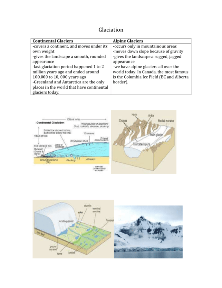
Glaciation Continental Glaciers -covers a continent, and moves under its own weight -gives the landscape a smooth, rounded appearance -last glaciation period happened 1 to 2 million years ago and ended around 100,000 to 10, 000 years ago -Greenland and Antarctica are the only places in the world that have continental glaciers today. Alpine Glaciers -occurs only in mountainous areas -moves down slope because of gravity -gives the landscape a rugged, jagged appearance -we have alpine glaciers all over the world today. In Canada, the most famous is the Columbia Ice Field (BC and Alberta border). Erosional Features Striations – can occur with both continental and alpine glaciers. Rocks along the bottom of the glacier scrap the bedrock like sandpaper and create large scratches. Spillways – also occur with both types of glaciers. As the glaciers starts to melt the water collects to form large rivers and these rivers create deep wide valleys. Depositional Features Till – material of clay, sand and gravel that is dumped by the glacier as it melts. Moraines – these are ridges of till that are left by the glacier at its snout, and sides. They may be many in an area, as the glacier advances and retreats. Drumlin – an ‘egged’ shaped hill created by a glacier. One end is steep and the other side gentle slopes downward. Erratic – A large boulder picked up and moved thousands of km away and then deposited by a glacier. Esker – a ‘s’ shaped hill. Looks like a snake from an aerial view. Created by a river flowing underneath the glacier. Glacial Features in Southern Ontario Moraines Ingersoll – an east-west ridge of till deposited by the edge of a glacier when it stop moving for a period of time, runs along Commissioners Rd (Warbler woods to Ingersoll) Arva/Brescia – was deposited by two glaciers pushing against each other 10,000 to 20,000 years ago, part of the moraine runs through the university and north towards Lucan. Kettle Ponds Sifton Bog – the bog depression was once occupied by a large block of ice. It left as the last glacier melted around 13,000 years ago. Under the vegetation is a thick peat layer, which rests on the stony soil or till which surrounded the ice block. When the block melted, the depression or kettle remained. The glacial deposits are about 25 m thick and cover limestone bedrock about 375 million years old. Westminister Ponds – the ponds occupy kettle depressions made by large blocks of ice, which left when the last glaciers started melting 13,000 years ago. They occur in the Ingersoll moraine and pieces of white chert and black from the till are still found by the ponds. Glacial Lake Lake London – melt water from the glacier was trapped by ice and moraines the water collected in the valley between the two moraines to form Lake London. The Thames River is all that is left from this old lake. In places you can see evidence from the deposits of the lake, silt and clay have been eroded by creeks and mudslides, forming steep slopes and ravines around the Thames R. Spillways Meadowlily Woods – is situated within a glacial spillway carved by meltwater through the Ingersoll moraine. Over thousands of years, three distinct terraces have been carved into the moraine’s north-facing slope by the erosive forces of the Thames. The Medway Valley – is an ancient spillway carved by glacial melt water through the Arva moraine. The riverbank displays clear traces of the two glaciers. The river meanders across the spillway, continually eroding its banks and exposing layers of stony mud, (till, formed at the foot of the glacier), mud, sand and gravel. Stones in the banks and river comprise several rock types derived from bedrock throughout S. Ontario and the Canadian Shield. The glacial deposits are about 25m thick and cover limestone bedrock formed in tropical seawater 375 million years ago.

