Latitude and Longitude Activity
advertisement

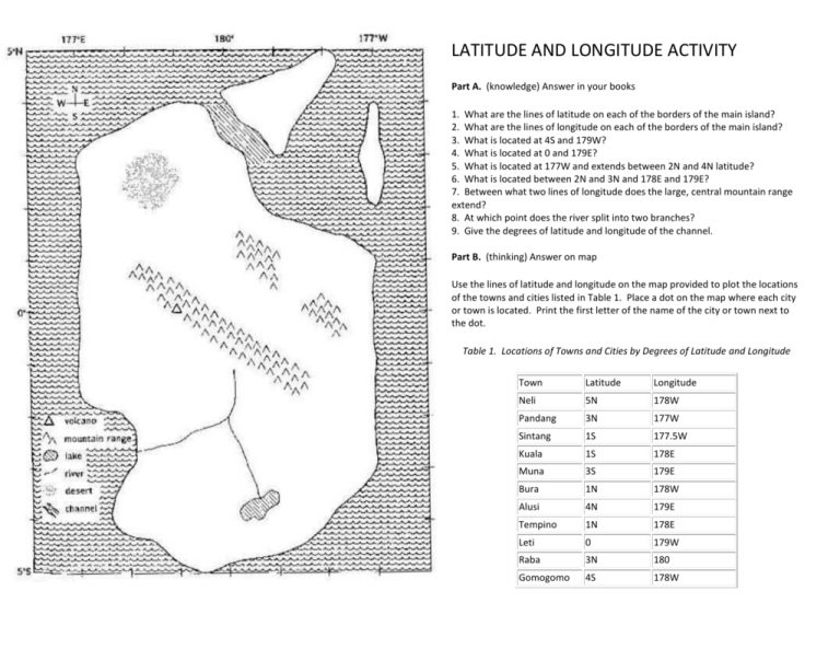
LATITUDE AND LONGITUDE ACTIVITY Part A. (knowledge) Answer in your books 1. What are the lines of latitude on each of the borders of the main island? 2. What are the lines of longitude on each of the borders of the main island? 3. What is located at 4S and 179W? 4. What is located at 0 and 179E? 5. What is located at 177W and extends between 2N and 4N latitude? 6. What is located between 2N and 3N and 178E and 179E? 7. Between what two lines of longitude does the large, central mountain range extend? 8. At which point does the river split into two branches? 9. Give the degrees of latitude and longitude of the channel. Part B. (thinking) Answer on map Use the lines of latitude and longitude on the map provided to plot the locations of the towns and cities listed in Table 1. Place a dot on the map where each city or town is located. Print the first letter of the name of the city or town next to the dot. Table 1. Locations of Towns and Cities by Degrees of Latitude and Longitude Town Latitude Longitude Neli 5N 178W Pandang 3N 177W Sintang 1S 177.5W Kuala 1S 178E Muna 3S 179E Bura 1N 178W Alusi 4N 179E Tempino 1N 178E Leti 0 179W Raba 3N 180 Gomogomo 4S 178W Part C. (application) Answer on map Make roads on the map by connecting the following towns and cities with straight dashed lines. Remember, roads do not go directly through huge mountain ranges or directly across lakes. You will have to pick sensible routes. Alusi to Raba Raba to Tempino Raba to Leti Leti to Bura Kuala to Tempino Sintang to Bura Sintang to Gomogomo Muna to Gomogomo Muna to Kuala Part D. (application) Answer on map Assume that the distance covered by 1 of latitude or longitude is 110 km. Measure the distance in centimeters between 179W and 180. Then divide 110 km by this measurement to find out how many kilometers equal 1cm on the map. What is the scale of your map? Part E. (application) Answer on map Use the scale you developed in Part D to find the following distances (BE SURE TO LABEL YOUR ANSWERS IN KILOMETRES): 1. 2. 3. 4. 5. 6. Bura to Gomogomo by road. Tempino to Gomogomo by air Muna to Neli by air. Pandang to Kuala by air. What is the shortest distance by road you can travel to get from Alusi to Gomogomo? (Measure the distance to the nearest centimeter, then convert to kilometres.) If you had to make a round trip journey by air between Alusi and Gomogomo, what distance would you have to travel? Marking Scheme KnowledgeThinking- /10 (Part A) /10 CommunicationApplication - /20 (Part B) /10 – for overall neatness of activity (Parts CDE)


