The Physical Geography of North America SSWG8: The student will
advertisement
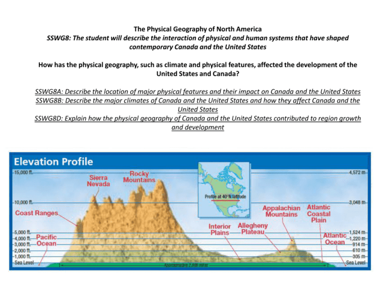
The Physical Geography of North America SSWG8: The student will describe the interaction of physical and human systems that have shaped contemporary Canada and the United States How has the physical geography, such as climate and physical features, affected the development of the United States and Canada? SSWG8A: Describe the location of major physical features and their impact on Canada and the United States SSWG8B: Describe the major climates of Canada and the United States and how they affect Canada and the United States SSWG8D: Explain how the physical geography of Canada and the United States contributed to region growth and development What are the major landforms that make up North America? SSWG8A: Describe the location of major physical features and their impact on Canada and the United States Western Mountains, Plains, and Plateaus – Tectonic plate collisions in the past created a series of sharppeaked mountains called the Pacific Ranges (Sierra Nevada, the Cascade, Coast Range, and the Alaska Range) – The Alaska Range is where you find the highest point on the continent, Mount McKinley – The Rocky Mountains also created as a result of tectonic activity – The Rocky Mountains link the United States and Canada, from New Mexico to Alaska Western Mountains, Plains, and Plateaus – Dry Basins and plateaus fill the area between the Pacific Ranges and the Rockies – Colombia Plateau in the north was formed by lava that seeped from cracks in the earth – Colorado Plateau, heavily eroded, has flat-topped mesas – Colorado Plateau is the location of the Grand Canyon along the Colorado River – The Great Basin cradles Death Valley, the lowest place in the United States Western Mountains, Plains, and Plateaus – Canada’s plateaus are colder and narrower than those in the United States – East of the Rockies, the land falls and flattens to the Great Plains – The Great Plains reach elevations up to 6000 ft. – The plains appear flat, the land slopes downward to the Central Lowlands along the Mississippi River Eastern Mountains and Lowlands – East of the Mississippi, the land rise to the foothills of the Appalachian Mountains – At the edge of the Canadian plains is the Canadian Shield (giant core of rock around Hudson Bay and James Bay) – Rocky land makes up the eastern half of Canada and the northeastern United States Eastern Mountains and Lowlands – Appalachian Mountains, heavily eroded, are the oldest range in North America – Extend from Quebec to central Alabama – Between the Appalachian Mountains and the coastal lowlands is the Piedmont (wide area of rolling hills) – Many rivers cut through the Piedmont, flowing east to the Atlantic Coastal Plain – Southeast, the Gulf Coastal Plain extends toward Texas Islands – Islands were created by geologic forces – Oceanic islands, like Hawaii, are volcanic – Continental islands are un-submerged parts of the continental shelf- a shallow, underwater platform that forms a continental border Islands – Continental islands include Ellesmere, and Baffin Island – Islands can play an important economic role, such as Newfoundland, Prince Edward Island, Vancouver Island, and New York’s Manhattan How has the physical geography influenced the economic development of the region? SSWG8D: Explain how the physical geography of Canada and the United States contributed to regional growth and development Lakes and Other Waterways – Large deposits of coal, iron, and other minerals near the Great Lakes favored industrial & urban development – Coastal waterways provide a link between inland areas and the coast = important for economic development Lakes and Other Waterways – Great Lakes-St. Lawrence Seaway system (series of canals, the river, and other inland waterways) link the Great Lakes with the Atlantic Ocean – The St. Lawrence Seaway helped make cities along the Great Lakes trade and industrial centers Fossil Fuels and Minerals – Abundant supplies of petroleum and natural gas – Petroleum found in Texas and Alaska – Canada’s petroleum and natural gas found in Alberta – Coal is found in the Appalachian Mountains, Wyoming, and British Colombia – Rocky Mountains yield gold, silver, and copper Fossil Fuels and Minerals – Canadian Shield- rich in iron and nickel – Iron ore in northern Minnesota and Michigan – 33% of world’s potash (used for fertilizer) is found in Canada – Interest in finding new sources of fossil fuels, without disrupting the natural environment Fossil Fuels and Minerals – Mining involves heavy equipment, uses large quantities of water, & moves rocks and other natural materials – Mining can damage land, water, and air systems – Challenge for mining in the region is to find ways to remove and process minerals and metal resources with the least disruption to the ecosystem Fossil Fuels and Minerals – Efforts are made to restore land after the mining operation is finished – Land can be used as wildlife parks, tree farms and orchards, public hunting and fishing areas, or grazing livestock Timber and Fishing – Timber is a vital resource for both countries – Challenge is to harvest timber responsibly – must protect and forests and ecosystems to sustain the resource – Efforts to preserve forests include replanting trees, protecting animal species, and preserving old growth forests Timber and Fishing – Coastal waters of Atlantic and Pacific Oceans, and the Gulf of Mexico are essential for regional economy – Important fisheries for fish, shellfish, and other sea animals – Grand Banks off Canadian coast is one of the richest fishing grounds Timber and Fishing – Overfishing caused decrease in fish stocksCanadian government banned cod fishing – Countries are working together to protect species that are endanger of being overfished – Aquaculture has become a growing economic activity How do the climate regions of North America affect the United States and Canada? SSWG8B: Describe the major climates of Canada and the United States and how they affect Canada and the United States Southern Climates Warm and Wet Climates – Humid Subtropical in the Southeast is rainy, long muggy summers and mild winters – The southeast borders the Atlantic Ocean, there is no dry season – Deciduous forests extend to Louisiana, but much has been cleared for farming along Mississippi River – Wetlands & swamps has a variety of vegetation and wildlife (Everglades in Florida) Southern Climates Warm and Wet Climates – Late summer and early autumn, hurricanes can affect the coastline – The extreme tip of Florida has a tropical climate with a distinct dry season during the winter – Hawaii has a tropical wet climate that support rain forest vegetation Northern Climates Interior Climates – Humid continental climate can be found in the Great Plains region and extends to northeastern United States and southeastern Canada – Cold winters and hot summers – Great Plains region get moisture from winds that blow north along the Rockies from the Gulf of Mexico and cold winds that blow from the Arctic Ocean Northern Climates Interior Climates – Prairies are treeless expanses of grasses in the Great Plains region – Spring and summer storms called supercells affect the area causing many tornadoes – Areas west of the Great Plains have a steppe climate that has a mix of vegetation depending on elevation – Steppe climates are transitional climates between dry desert climates and humid interior climates Northern Climates Interior Climates – Rockies and Pacific Ranges have a highland climate – Coniferous forests are in the middle elevations – Timberline- elevation above which trees cannot grow, only lichens and mosses grow – Chinook- warm dry wind in early spring blows down the slopes of the Rockies melting the snow Northern Climates Coastal Climates – Ocean currents, westerly winds, and the Pacific mountains allow coast from northern California to southern Alaska to have a Marine West Coast climate – Mountains force wind up and they release moisture providing the region with over 100 inches of rain annually Northern Climates Coastal Climates – Winters are over cast and rainy, summers are cloudless and cool – Ferns, mosses, and coniferous forests Northern Climates High Latitude Climates – Large parts of Canada and Alaska have subarctic climates with frigid winters – High atmospheric pressure over Canada spawns the cold winds that chill much of the United States during winter – Winter blizzards are common in northern North America Northern Climates High Latitude Climates – Band of coniferous forests found from Newfoundland into the subarctic Yukon Territory – Along Arctic coast is in a Tundra climate zone – Area is inhospitable for most plants and few people live there SUMMARY 1) How do location near the coast and prevailing wind patterns affect climate in the southern United States? 2) What causes variations in climate and vegetation in most of the United States and Canada? 3) Explain how water, wind, and tectonic forces has influenced the landscapes of the United States of America and Canada 4) How are lakes and rivers important to economic development in the United States and Canada?
