TES - Geography - Rivers Planning
advertisement
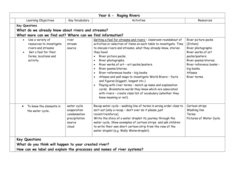
Year 6 - Raging Rivers Learning Objectives Key Vocabulary Activities Resources Key Questions What do we already know about rivers and streams? What more can we find out? Where can we find information? Use a variety of resources to investigate rivers and streams Get a feel for their forms, locations and activity. To know the elements in the water cycle. river stream source Getting a feel for streams and rivers – classroom roundabout of activities or selection of items on each table to investigate. Time to discuss rivers and streams, what they already know, stories they have! River picture packs. River photographs. River works of art – art packs/posters. River poems/stories. River references books – big books. Atlases and wall maps to investigate World Rivers – facts and figures (biggest, longest etc.) Playing with river terms – match up name and explanation cards. Brainstorm words they know which are associated with rivers – create class list of vocabulary (whether they know meaning or not). River picture packs (Itchen) River photographs. River works of art packs/posters. River poems/stories. River reference books – big books. Atlases River terms . water cycle evaporation condensation precipitation source cloud Recap water cycle – washing line of terms in wrong order class to sort out (only a recap – don’t over do it please just revisit/reinforce). Write the story of a water droplet its journey through the water cycle. Show examples of cartoon strips and ask children to write their own short cartoon strip from the view of the water droplet (e.g. Wally Waterdroplet). Cartoon strips Washing line Terms Pictures of Water Cycle Key Questions What do you think will happen to your created river? How can we label and explain the processes and names of river systems? Have an understanding of river processes and patterns. understand riverine vocabulary produce labelled annotated diagrams of rivers created on playground – label, describe and explain process. mouth source meander ox-bow lake tributary delta erosion deposition landscape transportation confluence waterfall estuary channel lake hill mountain valley Playground Rivers Creating a river system on slope of playground using a mix of peat, pea gravel, sand and soil – then hosing water over to see what happens. (See Instruction Booklet). source meander tributary mouth Petty’s Brook Mystery Children first predict the course of the river and then place river terms once created. mix of peat, pea gravel, sand and soil watering can plastic sheet string cardboard for labels Once practical activity is complete write up: 1) an annotated diagram explaining how to make the river e.g. equipment needed, instructions on what we did – predictions, creating river, labelling. 2) What the river shows– annotated diagrams of river created – labels, descriptions and explanations e.g. Deposition = is where the river slows down and loses energy and the rivers load is dropped on the side of the river where the water flows more slowly. marker pens County website has instructions for making playground rivers physical features Key Question What is Petty’s Brook like? To identify some of the physical aspects of a local river using secondary sources. ‘Where do I start and where do I go?’ - Mystery stream – solve it! Using maps locate source and mouth of our river. Children draw a maplet of Petty’s Brook to show its course. Use grid references Local maps showing Petty’s Brook scale1:10,000 or smaller Develop observational skills Use fieldwork techniques. To identify and describe physical aspects of a local river first hand Present findings clearly using text, maps and diagrams flood flood plain water speed flow rate of flow depth bank human features maplet cross section/ profile/ transect drawing Visit Petty’s Brook – Petty’s Brook Detectives Risk assessment Letter from South-East Water Agency ‘We appear to have lost our records on Petty’s Brook between x and y in Chineham. 1:10,000 and smaller scale maps of Petty’s Brook Dog biscuits! (that float!) As we are in charge of managing rivers in your region it is crucial that our records are up to date. Cameras Last year we were criticised when areas flooded so we need to know as much as possible about our streams and rivers.’ Tape measures / Measuring sticks During visit children produce annotated maplet of a section of Petty’s brook. Measure width, depth, speed of flow. Stop watch wellies Write a report for the agency, using their own statistics. Assessment activity: Maplet/letter to include: - Annotated diagrams of river/stream – labels + description of what is happening. - Information gathered about speed, width and depth of the stream. - Information gathered on erosion and deposition hotspots (could be marked on diagram of stream). - Evidence of any human interactions. Key Question What is the River Itchen like? Research a local river using maps, photos and the internet. Identify and explain physical features of the river. journey Read – The Waters Journey, Schmid, E. Explain that the children are going to research a local river (River Itchen) – use virtual tour on Hampshire County Website as start point. Use maps (pinned onto wall) and websites below to locate and follow the river from source to mouth. In groups produce own version of The Waters Journey about the River Itchen – make into a book using photos from web or pictures drawn – each group could produce own book or each group work on a different section of the river. ICT LINK – use Word to paste pictures into an add text, sound and graphics. Hants county website = county intranet then curriculum – geography – examples of work – virtual tour of Itchen (and others). www.multimap.co.uk www.streetmap.co.uk www.upmystreet.co.uk www.192.com (zoom in and it goes to aerial pictures) Key Question How is the River Itchen different from a larger regional river (Usk)? Maps Copies of River Itchen photo trail Questions sheet to use when investigating river on website. Virtual tour of River Itchen on Hants County website Compare and contrast two rivers using a Venn diagram. Identify features that are the same and different about the rivers. Ask geographical questions. national regional local Compare local river (River Itchen) to a regional river (River Usk) River flight video CHILDREN WILL NEED TO HAVE WATCHED RIVER FLIGHT VIDEO PRIOR TO THIS SESSION. Post-its PE Hoops Ask the children about what their memories of the River Itchen are (Itchen Memories) - record on postcard sized bits of paper. Notes from watching video Compare Regional River (Usk) to Itchen – similarities and differences. Make a large Venn diagram using big PE hoops. Use Venn to draw out features that are: - Only seen at the R. Itchen. - Only seen at the R. Usk. - Seen at both rivers. Record as a comparison between the two rivers – e.g. record Venn and bullet point the features above. Key Question What features do rivers have? Research aspects of rivers using books and internet. Use geographical vocabulary associated with rivers. Play ‘river snap’ – match terms to pictures Use two sets of cards for each group of 4 children (mixed ability). Play ‘snap’ – call when two pictures or two names match or a picture and a name match. Take each picture in turn and write a definition for it onto another snap card. Add other cards in to game for vocabulary associated with rivers. Feed back terms and definitions. Display as a class glossary of terms. River snap game Extra cards River vocabulary words on cards for glossary Key Question What can we learn about World Rivers? Research and present information about a well known world river to a group. international Secret River Scavengers Scavenger Hunts – world rivers. Facts and Figures – amaze your friends!! Brainstorm with class what scavengers do – e.g. collect information. Explain that each group (3-4) is going to investigate a secret world river. Card with rivers on - Need to emphasise secret. Crib sheet attached to copy and give to helpers. Atlases One lesson to collect information. May need to be based in ICT suite with books and then send each group off to scavenge from library or people). Resouce books – rivers Pictures/photos of rivers How: - - - Each group is given an envelope with the name of their secret river in – Amazon, Mississippi, Nile, Ganges, Rhine, and Yellow River. Then have to hunt for information using the following sources – book box, Library, Pictures/photos displayed, internet searches, maps and atlases, asking people (need to rope in some willing assistants TAs, parent helper, to have crib sheets with info on so children can come and secretively ask if they know anything about their river). Groups will need time (another lesson) to prepare their presentations where they will present 10 clues (hardest clue first down to very easy) to rest of class so they can try to guess/work out the group’s secret river. ICT suite Key Question What have we learnt about rivers? Present information about rivers clearly and in an eye catching way. Summarise what they have learnt during the study unit. Raging Rivers Assessment activity: Final piece of work – either pairs or group work to produce their own ‘Raging Rivers’ booklet/video/virtual tour/poster – the format can be their choice if given the options. They should use the Raging Rivers Horrible Geography book as a source of ideas and inspiration! They need to look back over the term and produce a piece of work that could be used next time year 6 do the rivers unit to help them to understand rivers and learn more about them (a general look at Rivers not any specific one). Must include: - A map of a river – labelled and terms explained. - Descriptions of particular features. - Facts and figures about World Rivers.

