Glaciers
advertisement

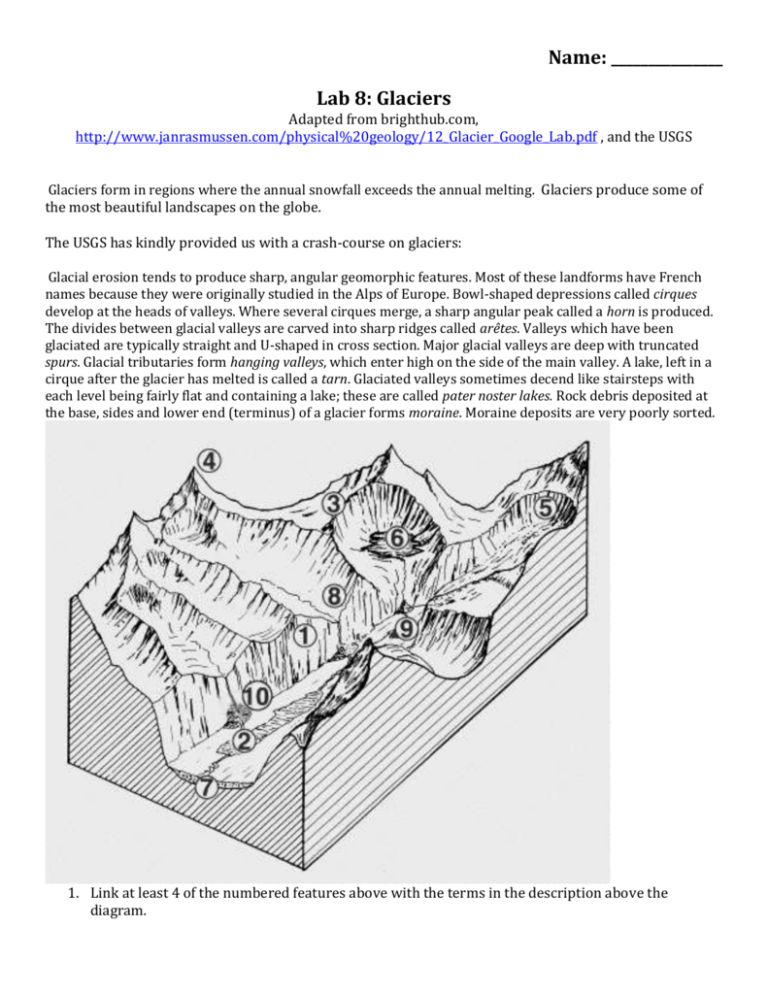
Name: _______________ Lab 8: Glaciers Adapted from brighthub.com, http://www.janrasmussen.com/physical%20geology/12_Glacier_Google_Lab.pdf , and the USGS Glaciers form in regions where the annual snowfall exceeds the annual melting. Glaciers produce some of the most beautiful landscapes on the globe. The USGS has kindly provided us with a crash-course on glaciers: Glacial erosion tends to produce sharp, angular geomorphic features. Most of these landforms have French names because they were originally studied in the Alps of Europe. Bowl-shaped depressions called cirques develop at the heads of valleys. Where several cirques merge, a sharp angular peak called a horn is produced. The divides between glacial valleys are carved into sharp ridges called arêtes. Valleys which have been glaciated are typically straight and U-shaped in cross section. Major glacial valleys are deep with truncated spurs. Glacial tributaries form hanging valleys, which enter high on the side of the main valley. A lake, left in a cirque after the glacier has melted is called a tarn. Glaciated valleys sometimes decend like stairsteps with each level being fairly flat and containing a lake; these are called pater noster lakes. Rock debris deposited at the base, sides and lower end (terminus) of a glacier forms moraine. Moraine deposits are very poorly sorted. 1. Link at least 4 of the numbered features above with the terms in the description above the diagram. Today, major contintental glarciers are found only in Antarctica and Greenland. The unique erosional and depositional features that they create are found in Northern Europe and North America and enable us to determine the nature and extent of past continental glaciation. Terminal moraines mark the margins of the ice. Ground moraine is deposited beneath the glacier and may be locally shaped into streamlined hills called drumlins. Melt water from the ice deposits an outwash plain consisting of stratified gravels, sands and silts (drift) deposited by braided streams flowing from the glacier. Sinuous ridges called eskers result from sediment deposited on the floor of former ice tunnels. Ice blocks which break off from the glacier or are left behind as the glacier recedes and become surrounded by sediment produce kettles when they melt away. Large rocks left behind by the ice are called erratics. 2) As a class, let’s go into Google Earth and take a tour up the Yakima River. Discuss the features you observe that were formed by glacial processes. Record the class discussions below. For the next questions, we will focus on the glacial features of Yosemite National Park. The Valley of Tenaya Creek Valley of Tenaya Creek, Yosemite National Park. Half Dome is on the right, and North Dome is on the left. 3. How would you describe the shape of the profile? 4. How do you think this profile differs from one of a valley carved entirely by a river? 5. As a class open Google Earth and focus on the Wenatchee River floodplain between Leavenworth, WA and Wenatchee, WA. Discuss the features you observe that were formed by glacial processes. Record the class discussions below. 6. Now let’s look at the Cascades. As a group choose an area on the Cascades of Washington likely to have been affected by glacial processes. Again, discuss the features you observe that were formed by glacial processes. Record the classes’ discussions below. In Google Earth, enter the coordinates below into the query bar: 59.411909 -138.311455 Southeast Alaska, USA. 1. Using the coordinates above, scan generally NE up the glacier and locate at least four different glacial landforms. 2. Mark each landform or phenomenon you find with the ‘Placemark’ tool, label it, and record its latitude and longitude in a table. The placemark tool looks like a pushpin. 3. Save several images from Google Earth showing these landforms. File – save – save image. Put these images into your word document so I can see them. A few potentially helpful links: Wikipedia entry on Glaciers: http://en.wikipedia.org/wiki/Glacier Glacier National Park: http://www.nps.gov/glac/index.htm Glacier Bay National Park: http://www.nps.gov/glba/index.htm Wikipedia entry on Ice Ages: http://en.wikipedia.org/wiki/Ice_age The Great Ice Age: http://pubs.usgs.gov/gip/ice_age/ NOAA web site on Glaciation: http://www.ncdc.noaa.gov/paleo/glaciation.html Glaciers with Time: http://www.homepage.montana.edu/~geol445/hyperglac/time1/ Milankovitch Cycles: http://en.wikipedia.org/wiki/Milankovitch_cycles


