Unit 1
advertisement
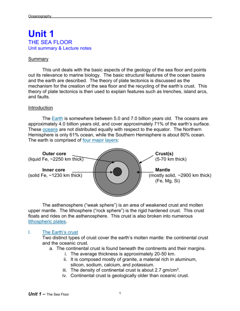
Oceanography Unit 1 THE SEA FLOOR Unit summary & Lecture notes Summary This unit deals with the basic aspects of the geology of the sea floor and points out its relevance to marine biology. The basic structural features of the ocean basins and the earth are described. The theory of plate tectonics is discussed as the mechanism for the creation of the sea floor and the recycling of the earth’s crust. This theory of plate tectonics is then used to explain features such as trenches, island arcs, and faults. Introduction The Earth is somewhere between 5.0 and 7.0 billion years old. The oceans are approximately 4.0 billion years old, and cover approximately 71% of the earth’s surface. These oceans are not distributed equally with respect to the equator. The Northern Hemisphere is only 61% ocean, while the Southern Hemisphere is about 80% ocean. The earth is comprised of four major layers: Outer core (liquid Fe, ~2250 km thick) Crust(s) (5-70 km thick) Inner core (solid Fe, ~1230 km thick) Mantle (mostly solid, ~2900 km thick) (Fe, Mg, Si) The asthenosphere (“weak sphere”) is an area of weakened crust and molten upper mantle. The lithosphere (“rock sphere”) is the rigid hardened crust. This crust floats and rides on the asthenosphere. This crust is also broken into numerous lithospheric plates. I. The Earth’s crust Two distinct types of crust cover the earth’s molten mantle: the continental crust and the oceanic crust. a. The continental crust is found beneath the continents and their margins. i. The average thickness is approximately 20-50 km. ii. It is composed mostly of granite, a material rich in aluminum, silicon, sodium, calcium, and potassium. iii. The density of continental crust is about 2.7 gm/cm3. iv. Continental crust is geologically older than oceanic crust. Unit 1 – The Sea Floor 1 Oceanography b. The oceanic crust makes up the ocean basins. i. The average thickness is approximately 5 km. ii. It is composed of basalt, a material rich in iron, and magnesium. iii. The density of oceanic crust is about 3.0 gm/cm3. iv. Oceanic crust is geologically young. Most of the earth’s new crust is formed under the ocean, therefore is oceanic crust. II. The Hydrosphere a. The oceans contain approximately 97.22% of the water on earth. b. Glaciers hold less than 2.15% of the earth’s water. c. Ground water makes up about .6% of the earth’s water. d. The atmosphere, lakes, rivers, etc… contain less than .01% of the earth’s water. e. There are 5 major ocean basins: Pacific, Atlantic, Indian, Arctic, and Southern. 1. 2. 3. 4. 5. Avg. depth (m) Area (millions of km2) % of total oceans Pacific 4,280 180.0 48.0% Atlantic 3,930 106.5 28.0% Indian 3,960 75.0 20.0% Arctic 1,205 14.0 4.0% Southern: an ocean basin consisting of a combination of the most southern Pacific, southern Atlantic, and southern Indian; surrounding Antarctica. **Avg. global ocean depth = 3.9 km or 2.4 miles or 13,000 ft. III. Ocean Topography a. Continental shelf i. Submerged edge of the continent that makes up only 8% of the ocean basin, but is the most biologically active part of the ocean. ii. Varies in width from less than 1 km on the Pacific coast of South America to more than 750 km on the Arctic coast of Siberia. b. Continental slope i. The closest thing to the exact edge of the continent. It descends down to the deep-sea floor. ii. Reaches a depth of 3 to 5 km. c. Submarine canyons i. During times of low sea level in the past, most of the continental shelves were exposed. At these times, rivers and glaciers flowed across the shelves and eroded deep canyons. When the sea level rose, these canyons gave rise to much larger submarine canyons. ii. Examples include Monterey submarine canyon and La Jolla trench. d. Continental rise i. Sediment that moves down a submarine canyon accumulates at the canyon’s base. Unit 1 – The Sea Floor 2 Oceanography e. Abyssal plains i. Most of the deep-sea floor is flat and lies at a depth of 4 km on average. f. Seamounts i. These are submarine volcanoes that dot the abyssal plain. g. Trenches i. Located at the base of the continental slope, and usually reach a depth of greater than 6 km. ii. Trenches are usually associated with convergent plate boundaries. iii. The deepest location on the ocean floor is the Mariana’s trench in the western Pacific reaching a depth of over 11 km. h. Mid-Ocean Ridge System i. This is the location of the earth’s crustal expansion; know as the “spreading center.” ii. It is the largest geographical feature on planet. (Like the seams on a baseball) iii. Its total length is over 65,000 km (1.5 times around planet). iv. It has an average height of 1-2 km over ocean floor, with a central rift between 12 and 48 km. IV. Plate Boundaries a. Divergent ( ) i. Where two or more crustal plates are directed away from each other. ii. Associated with the Mid-ocean ridge system. iii. Location of numerous volcanic eruptions and earthquakes. b. Lateral ( ) i. Where plates slip past each other. Creates heavy earthquake activity. ii. California’s San Andreas Fault is an example. c. Convergent ( ) i. Where crustal plates are directed into each other. Heavy volcanic & earthquake activity. ii. Convergent boundaries create trenches. 1. Where two continental plates meet, there is a build-up of crust into mountain ranges such as the Himalayan Mountains in Asia. 2. Where a thicker continental plate meets a thinner oceanic plate, a subduction zone exists. This subduction zone creates massive volcanic activity. The Japan Islands were (are) created this way. Unit 1 – The Sea Floor 3 Oceanography V. Ring of Fire The “Ring of Fire” is a belt of active seismic activity encircling Pacific Ocean. This ring runs up the west coasts of South and North America, around the Aleutian Islands, and down the western edge of the Pacific Ocean to New Zealand. VI. Hotspots Hotspots are areas of hot magma rising up from deep in the mantle that punch their way through the weak crust above them. These hotspots are stationary in their location within the mantle. As the plate moves over the hotspot, it creates volcanic seamounts that eventually become island chains in the middle of the plate. The Hawaiian-Emperor Island chain is an example. Hotspot currently creating a new Hawaiian island south of the main island Hawaii, named Loihi. Unit 1 – The Sea Floor 4


