Rodinia Maps Name Date Period Notes Page on Massachusetts
advertisement
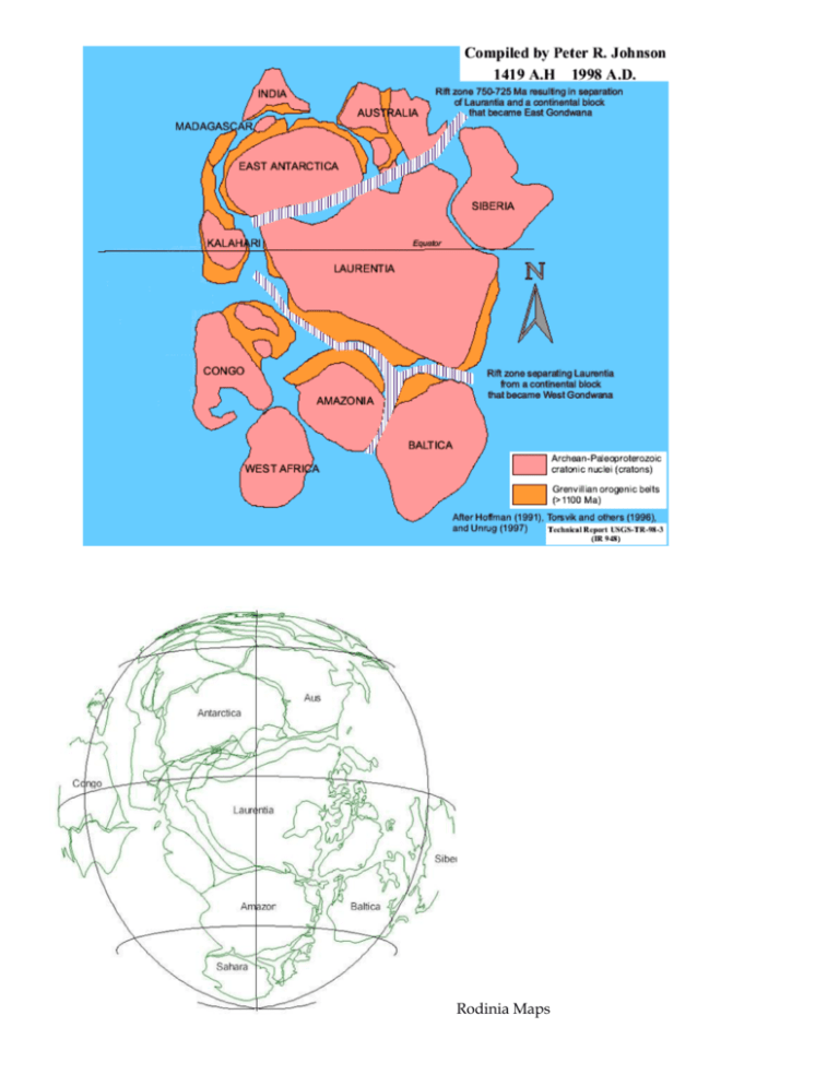
Rodinia Maps Name _________________________________ Date _________________________ Period ______________ Notes Page on Massachusetts Geologic History: A billion years in 45 minutes or less! How to abbreviate billions, millions, and thousands of years Billions of years = Giga Anna or Ga Millions of years = Mega Anna or Ma Thousands of years = Kilo Anna or Ka 1 billion years ago: Write notes and draw pictures (See Rodinia picture in handout) Rodinia supercontinent forms 1.2 Ga during the Neoproterozoic Era of the Proterozoic Eon. Supercontinent traps heat in the mantle, causing the crust to expand and “upwarp.” This leads to the formation of rift valleys and the break up of Rodinia Very early evidence of multicellular life in the oceans. Global cooling triggers Snowball Earth which lasts from 850 Ma to 650 Ma (the Cryogenian Period). -possibly triggered by low CO2 in the atmosphere OR the existence of such a large land mass near the south pole a very large surface to cover with snow. White color of snow reflects sun’s heat away from Earth and Earth cools to 50 below Zero Celsius. -Entire Earth iced over. The only places not frozen are around active volcanoes. -Eventually volcanoes put enough CO2 into the atmosphere that global warming melts the ice. 700 million years ago: Write notes and draw pictures Rodinia has broken up. Snowball Earth still covers the planet in ice. Ocean spreading is happening as Rodinia’s pieces spread apart. 650 Ma Ice has melted. Multicellular life shows up in a new period named the Ediacaran Period. 500 million years ago Ocean between Africa and North America (called Laurentia by geologists) stops spreading. Ocean (called Iapetus Ocean, named after Iapetus, the father of Atlas) begins to close. As Africa and Laurentia move closer together, subduction zones form in the ocean and volcanic island chains form. Near Africa at least 4 volcanic island chains form: Avalonia, Meguma, Nashoba, and Merrimack Near Laurentia, at least 2 volcanic island chains form: Shelburne Falls and Bronson Hills. These bump into each other as the ocean closes. This is during the Cambrian Period, when the first organisms with shells and skeletons evolve. The east coast of North America is in the Albany, NY area at this time. Sand from the beaches eventually will become sandstone, and later it will be metamorphosed into quartzite (Cambrian Beach Party). Offshore, the limy deposits of seashells will eventually turn into limestone, and later be metamorphosed into marble (Natural Marble Bridge) From 500ma to 300ma years ago: The Paleozoic Era (most of it, at least) Iapetus Ocean is closing between Africa and Laurentia (North America), creating a Ring of Fire.--> Subduction zones form on both sides of the ocean. Subduction creates trenches and volcanic island chains on either side of the ocean. At least 4 volcanic island chains form off the coast of Africa and 2 form off the coast of Laurentia (North America). African volcanic island chains named by geologists: Meguma (now under Cape Cod) Avalonia (Framingham, Natick, and Boston are now on Avalonia) Nashoba Merrimack Laurentian volcanic island chains named by geologists: Shelburne Falls Bronson Hills As the ocean closes, these volcanic island chains grow into “micro-continents.” The “micro-continents” collide with each other AND also get sandwiched between Africa and Laurentia. This geologic “train wreck” creates the Mid-Pangaea Mountains—a huge mountain range in the middle of Pangaea. The mountains formed by this collision are probably larger than the Himalayas. During this time, animals with skeletons and shells evolve (fish, clams, ammonites, trilobites). Some adapt to life on land, such as insects (giant dragonflies) and tetrapods (first 4-legged animals-like giant amphibians), and eventually early reptiles. No dinosaurs or mammals yet. No grass or flowers yet. Lots of giant fern trees. 300 ma to 250 ma Final assembly (coming together) of Pangaea. Sandstone and limestone of North Adams is metamorphosed by the continental continental convergence (sandstone quartzite, limestone marble) Rocks of Shelburne Falls have been driven deep underground by mountain building and are being turned into gneiss. End of the Paleozoic Era: The last part is called the Permian Period and ends with a huge extinction event in which most life on Earth dies out. Probably cause: massive volcanic eruptions in Siberia, known as the Siberian Traps. A meteor impact OR a superplume of hot mantle material may have been the source of these volcanic eruptions. Mr. Ward thinks it was a superplume, but this is a scientific debate. Life that does survive includes our early reptile ancestors, known as the “synapsids” (aka: mammal-like reptiles) No dinosaurs or true mammals until LATE in the next geologic period: The Triassic (first part of the Mesozoic Era) 250 to 180 ma Beginning of the Mesozoic Era (Triassic Period: 250 Ma to 200 Ma, followed by Jurassic Period: 200 Ma to 145 Ma) Dinosaurs first show up at 230 Ma and Mammals soon follow at 220 Ma. All supercontinents must come to an end: Pangaea traps heat in the mantle like a giant blanket. The convection currents (like in a lava lamp) that pushed the continents together change direction. The center of the continent upwarps and starts to crack up. Rift valleys form as currents in the mantle start pulling at Pangaea. Enormous lava flows cover large areas of eastern North America, west Africa and parts of Europe. This region of lava flows is called “C.A.M.P.” by geologists: Central Atlantic Magmatic Province. Some of those rift valleys eventually grow into the Atlantic Ocean and they are still growing today, creating new sea floor at the Mid-Atlantic Ridge. Most of the rift valleys fail, like the Connecticut Rift Valley (CRV), but they dramatically change the landscape: The CRV drops land several thousand meters, and the surrounding mountains erode rapidly into it, forming giant alluvial fans (Mt. Sugarloaf and Mt. Toby). Since the crust is cracking up and thinning, magma comes up from the mantle and forms a fissure flow at Turner’s Falls and a volcano in Holyoke that we call Mt. Tom. The eruptions stop, and the valley continues to be filled with sediment from the mountains eroding away. Dinosaurs leave tracks in these sediments (they had probably been attracted to the valley because there was water here—Mid-Pangaea was a very dry place otherwise) Eventually, the valley drops more on the eastern side (Eastern Border Fault) than the western side, leaving the entire valley tilted. Rifting stops as the Mid Atlantic Ridge grows. 180 ma to 2ma Land erodes down to nearly sea level and no Cretaceous Period deposits are left (except on the south side of Martha’s Vineyard). Uplift occurs (probably be heating up of the lower crust by currents in the mantle). As the land rises, erosion increases and the Connecticut River starts to cut down through the sediments of the Connecticut Rift Valley. The uplift is fast enough that the river has enough energy to cut through the hard lava rocks (basalt) at Mt. Tom, creating the Mt. Tom Water Gap (where we were able to drive between two parts of the volcanic mountain range there). The last 2 million years Ice Age shapes the landscape. At least 18 glacial advances (glaciations) scrape rock, shape Mt. Sugarloaf, pile up till and create eskers and kettle ponds like the ones you saw at Cranberry Pond. Glaciers push forward moraines of sand and rock and pile them up to form Martha’s Vineyard, Long Island, Nantucket and Cape Cod. They leave erratic boulders all over the landscape. When they melted, they filled the Connecticut River Valley with a giant lake we call Glacial Lake Hitchcock. Meltwater from the glaciers also carves the potholes at Shelburne Falls AND the chasm at the Marble Bridge. Framingham is mostly the bottom of a lake of glacial meltwater.


