1st Emergency Report of Typhoon Soudelor
advertisement
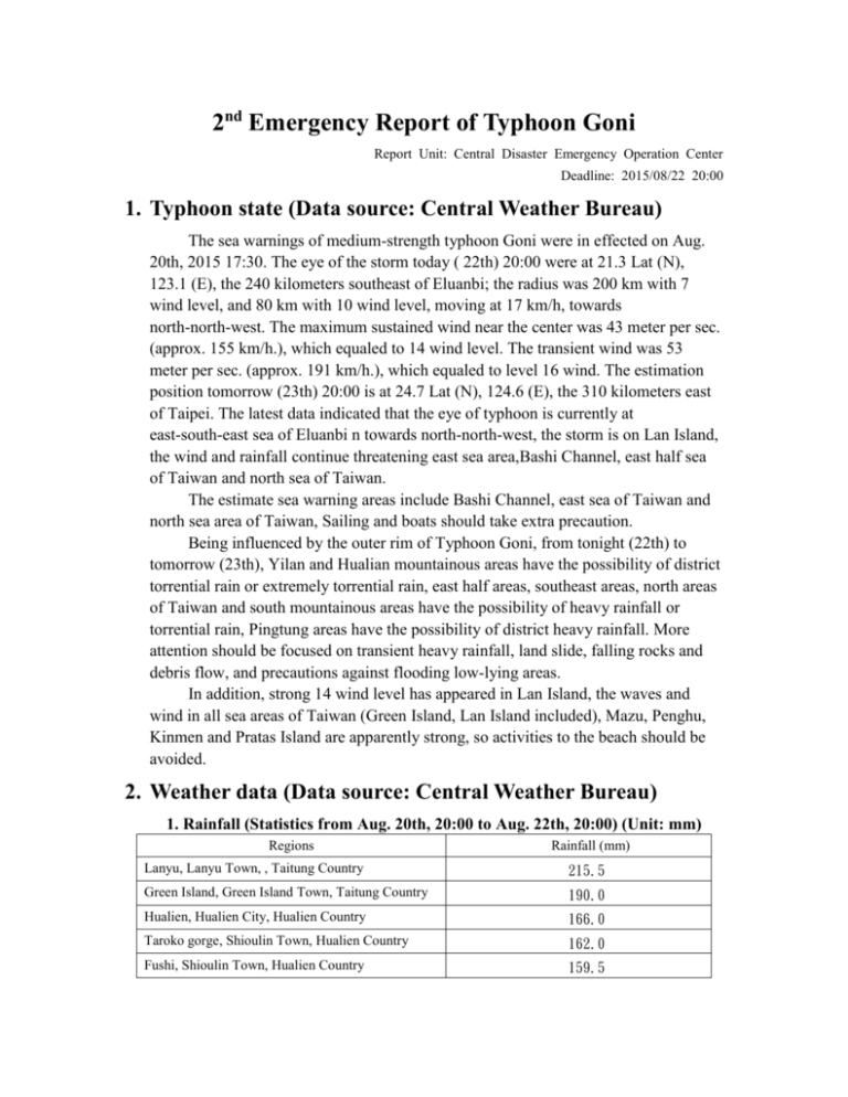
2nd Emergency Report of Typhoon Goni Report Unit: Central Disaster Emergency Operation Center Deadline: 2015/08/22 20:00 1. Typhoon state (Data source: Central Weather Bureau) The sea warnings of medium-strength typhoon Goni were in effected on Aug. 20th, 2015 17:30. The eye of the storm today ( 22th) 20:00 were at 21.3 Lat (N), 123.1 (E), the 240 kilometers southeast of Eluanbi; the radius was 200 km with 7 wind level, and 80 km with 10 wind level, moving at 17 km/h, towards north-north-west. The maximum sustained wind near the center was 43 meter per sec. (approx. 155 km/h.), which equaled to 14 wind level. The transient wind was 53 meter per sec. (approx. 191 km/h.), which equaled to level 16 wind. The estimation position tomorrow (23th) 20:00 is at 24.7 Lat (N), 124.6 (E), the 310 kilometers east of Taipei. The latest data indicated that the eye of typhoon is currently at east-south-east sea of Eluanbi n towards north-north-west, the storm is on Lan Island, the wind and rainfall continue threatening east sea area,Bashi Channel, east half sea of Taiwan and north sea of Taiwan. The estimate sea warning areas include Bashi Channel, east sea of Taiwan and north sea area of Taiwan, Sailing and boats should take extra precaution. Being influenced by the outer rim of Typhoon Goni, from tonight (22th) to tomorrow (23th), Yilan and Hualian mountainous areas have the possibility of district torrential rain or extremely torrential rain, east half areas, southeast areas, north areas of Taiwan and south mountainous areas have the possibility of heavy rainfall or torrential rain, Pingtung areas have the possibility of district heavy rainfall. More attention should be focused on transient heavy rainfall, land slide, falling rocks and debris flow, and precautions against flooding low-lying areas. In addition, strong 14 wind level has appeared in Lan Island, the waves and wind in all sea areas of Taiwan (Green Island, Lan Island included), Mazu, Penghu, Kinmen and Pratas Island are apparently strong, so activities to the beach should be avoided. 2. Weather data (Data source: Central Weather Bureau) 1. Rainfall (Statistics from Aug. 20th, 20:00 to Aug. 22th, 20:00) (Unit: mm) Regions Rainfall (mm) Lanyu, Lanyu Town, , Taitung Country 215.5 Green Island, Green Island Town, Taitung Country 190.0 Hualien, Hualien City, Hualien Country 166.0 Taroko gorge, Shioulin Town, Hualien Country 162.0 Fushi, Shioulin Town, Hualien Country 159.5 2. Wind speed Regions Transient wind (level) Green Island, Green Island Town, Taitung Country 14 3. Response 1. The establish situation of Disaster Respond Centers in counties (Data source: National Fire Agency) Category Established Name of country(ies) County 3 Level 2: New Taipei City, Yilan Country, Hualian County Harbor 2 Level 2: Taichung harbor, Hualiang harbor 2. The planning of warning areas (low-lying 2, mountainous 3, seaside 12, rivers 63 and others (harbor) 4, 84 in total. Persuasion list 0, whistle-blowing list 0) (Data source: National Fire Agency) Planning number Category Execution result Low-lying mountainous Seaside river others Persuasion whistle-blowing Total 2 3 12 63 4 0 0 New Taipei City Yilan Country Hualian 0 1 3 3 4 0 0 0 0 6 35 0 0 0 2 2 3 25 0 0 0 County 3. Communication to hikers (Data source: National Fire Agency) Tabulation time: report time: 20:00 Aug. 22nd 2015 Submit Cancelled Communicated after advising Off the Haven’t Safe house Evacuated Leaving responded mountain Cases Persons Cases Persons Cases Persons Cases Persons Cases Persons Cases Persons Cases Persons 928 5,312 598 3,502 330 1,810 0 0 0 0 0 0 0 0 (Note: “Haven’t responded” referred to the hikers in the mountain haven’t connected with personnel, family or police for over 48 hours. The form is filed and reported by National Police Agency, Construction and Planning Agency.) 4. The settling of Fishermen of Mainland China (Data source: Council of agriculture) Time Settled persons on the ship Settled persons on the ground Total 2015/08/22 20:00 1,447 199 1,646 5. Work and class suspension status (Data source: National Fire Agency) (1) Today (22nd), Green Island, Lan Island of Taitung Country have suspended the work and class. (2) Today’s night (22) and tomorrow (23) Wulai District, New Taipei City has suspended the work and class. 4. Capacity and evacuation 1. Evacuation (Data source: Interior ministry civil affairs department) Evacuated 1 city (Wulai District), 2011 persons Category Evacuation New Taipei City 2,011 Total 2,011 2. Capacity Refuge shelter (Data source: Ministry of Health and Welfare) 151 shelters accumulated for 4,855 people in total. 73 shelters accumulated for 1798 people currently Category Cities, towns Shelters People New Taipei City 1 1 15 Total 1 1 15 3. Residence settlement camps (Data source: Ministry of National Defense) The capacity of national army: 100 residence settlement camps for 11,915 people (low density), 34,030 people (high density), 45,945 people in total. 5. Statistics of disaster 1. Disaster of critical infrastructure (Data source: Ministry of Economy, NCC) Normal 2. Traffic (Data source: Ministry of Transportation and Communication) (1) Road, bridge interruption and repairing 1 Provincial roads interruption: No. 9 Jia Xiaoyi passage closed due to rockfall, predict to recover at 06:00, 24th. 1 precautionary closure: No. 20 Southern Cross-Island Provincial HighwayMilu passage, predict to recover at 10:00, 23th. (2) Road and railway (normal.) (3) Suspension of airline (44 flights in total: domestic 42, international 2 on 22th.) (4) Suspension of shipping (78 flights in total on 22th) 3. Flood (Data source: Ministry of Economic Affairs) 2 flood places, 2 receded, 0 handling. Category Hualian County Total Flood (places) 2 2 Receded (places) Handling 2 0 2 0 Note 6. Response of national military supporting countries in disaster 1. Equipment of disaster response team (Data source: Ministry of National Defense) (1st disaster response team is 800 persons in total and departed after received the order in 10 mins. 2nd disaster response team is 1200 persons in total and departed after received the order in 3 hrs. The total military force is 2000 in total) Chart of disaster response teams of national military in Taiwan area Category st 1 disaster response 3rd Combat Area 5th Combat Area 4th Combat Area 2nd Combat area (North) (Central) (South) (East) 200 200 200 200 team Total 800 nd 2 disaster 300 300 300 300 response team Total 1200 2. Military forces in high-risk areas (data source: Ministry of National Defense) The total military forces in high-risk areas are 3620 persons, 491 machinery vehicles. Chart of Military forces and machinery equipment preset areas Army Special 3rd Combat 5th Combat Area 4th Combat 2nd Combat Category Flight Total Area (North) (Central) Area (South) Area (East) Department place Military forces(people) Machinery(EA) Each Country and City Each Country and Each Country and Each Country and Yilan Contry and City City City New Taipei City 669 814 1,545 546 89 161 181 60 46 3,620 491
