3-Cell Model & Jet Streams: Atmospheric Circulation Explained
advertisement
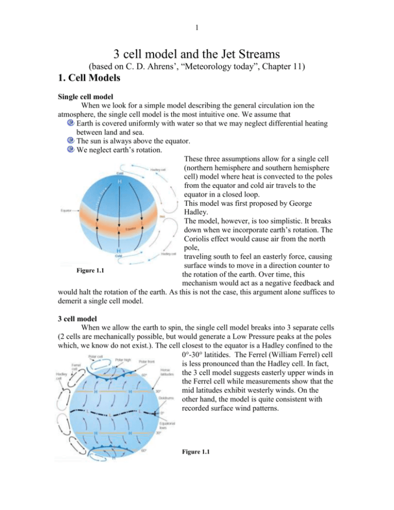
1 3 cell model and the Jet Streams (based on C. D. Ahrens’, “Meteorology today”, Chapter 11) 1. Cell Models Single cell model When we look for a simple model describing the general circulation ion the atmosphere, the single cell model is the most intuitive one. We assume that Earth is covered uniformly with water so that we may neglect differential heating between land and sea. The sun is always above the equator. We neglect earth’s rotation. These three assumptions allow for a single cell (northern hemisphere and southern hemisphere cell) model where heat is convected to the poles from the equator and cold air travels to the equator in a closed loop. This model was first proposed by George Hadley. The model, however, is too simplistic. It breaks down when we incorporate earth’s rotation. The Coriolis effect would cause air from the north pole, traveling south to feel an easterly force, causing surface winds to move in a direction counter to Figure 1.1 the rotation of the earth. Over time, this mechanism would act as a negative feedback and would halt the rotation of the earth. As this is not the case, this argument alone suffices to demerit a single cell model. 3 cell model When we allow the earth to spin, the single cell model breaks into 3 separate cells (2 cells are mechanically possible, but would generate a Low Pressure peaks at the poles which, we know do not exist.). The cell closest to the equator is a Hadley confined to the 0-30 latitides. The Ferrel (William Ferrel) cell is less pronounced than the Hadley cell. In fact, the 3 cell model suggests easterly upper winds in the Ferrel cell while measurements show that the mid latitudes exhibit westerly winds. On the other hand, the model is quite consistent with recorded surface wind patterns. Figure 1.1 2 Figure 1.3 Figure 1.4 Doldrums: Low pressure, light winds area near equatorial waters. The monotony of the whether has given rise to the expression “down in the doldrums”. The hot air rising over these waters produces large Cumulus clouds and thunderstorms, releasing a lot of latent heat and driving the Hadley cell. The tropopause acts as a ceiling where the rising air deflects to the poles. Subtropical Highs: sinking air at the 30s (anticyclones). As the air descends, it warms by compression. Subtropical areas are generally warm and dry, with clear skies and weak winds. The major deserts on earth are along the 30s latitudes. The name “Horse latitudes” is derived from the sad fact that many horses were thrown overboard along these latitudes as ships were stuck for weeks at the becalmed waters. Trade winds: air from the horse latitudes flows back towards the equator, twisting to the west due to the coriolis force. ITCZ(InterTropical Convergence Zone): along the equator, the northeast and south east trade winds converge and rise again with the continuing circulation of the Hadley cell. Westerlies: at the 30s, some of the descending air moves poleward, forming the westerlies (again, resulting from the coriolis force). Polar Front: as the westerlies move poleward, they encounter the polar front (cold air moving from the poles). The two masses of air differ in temperature and do not readily mix. At the Subpolar Low air rises and storms form. Some of the rising air moves back to the horse latitudes, completing the Ferrel cell and the rest move poleward, completing the Polar cell (also the weakest cell). 3 2. Layers of the Atmosphere Troposphere: where most air mass and wind action take place. Tropopause: where air stops cooling as it rises. Stratosphere: air heats with height. This might be due to the ozone (absorbs UV) maximum being just about at the height where the heating begins (30km). The shift from cooling to heating with increasing height is called Temperature Inversion. Mesosphere: air density and ozone density in particular is very thin. The air looses energy faster than it gains energy, hence cooling with increasing height resumes. Thermosphere: oxygen molecules (O2) dominate at this height. The ability of O2 to absorb heat resumes heating with height. Exosphere: atoms are loosely bounded to earth and easily bounce off to space. (mean free path of the order of a few km). Homosphere / Heterosphere: below the thermosphere the air is dense enough to mix (hence, homogeneous). Above the mesosphere, light and heavy molecules settle at different layers. Ionosphere: 70-80km and up, we have large concentrations of ions and free electrons. 4 3. Jet Streams “swiftly flowing air currents, thousands of km long, a few hundred km wide and only a few km thick. Wind speeds at the core of a jet stream often exceed 100 knots (1knot = 1.9km/h) and occasionally exceed 200 knots.” Jet streams are often found at the tropopause, at elevations of 10-15km. Figure 3.1 The subtropical jet stream is the dominant of the two. Averaging over many years raises doubts as to whether we may even regard the polar jet as a definable entity (N. P.). The jet streams meander in broad loops in a general westerly direction. Formation of the polar and subtropical jets The formation of the jet streams is attributed to two major mechanisms. First, the jets form along fronts of steep pressure gradients caused by the counter motion of hot and cold air masses. The steep pressure gradients intensify the winds and causes the jet streams. Secondly, both jet streams are westerly. The westerly motion of the subtropical jet stream is consistent with the conservation of angular momentum. If we look back at figure 1.1, we see that in the northern hemisphere, winds traveling equatorward, experience an easterly coriolis force and winds traveling poleward experience a westerly coriolis force. At the 30s, according to the 3 cell model, hot Hadley cell winds from the equator meet cold Ferrel winds from the poles. The coriolis bending of the two air masses are opposite. However, the air coming from the equator has greater angular momentum to begin with and larger mass. Thus, we would expect a westerly jet at the 30s.
