paleogeography (plate tectonics)
advertisement
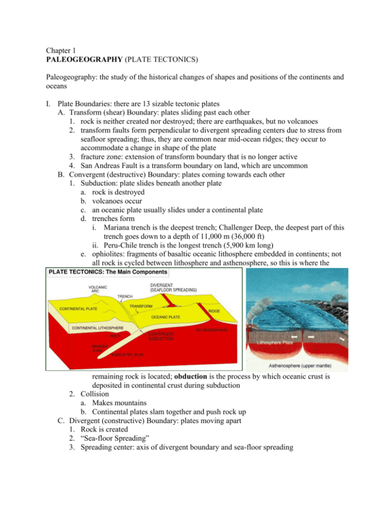
Chapter 1 PALEOGEOGRAPHY (PLATE TECTONICS) Paleogeography: the study of the historical changes of shapes and positions of the continents and oceans I. Plate Boundaries: there are 13 sizable tectonic plates A. Transform (shear) Boundary: plates sliding past each other 1. rock is neither created nor destroyed; there are earthquakes, but no volcanoes 2. transform faults form perpendicular to divergent spreading centers due to stress from seafloor spreading; thus, they are common near mid-ocean ridges; they occur to accommodate a change in shape of the plate 3. fracture zone: extension of transform boundary that is no longer active 4. San Andreas Fault is a transform boundary on land, which are uncommon B. Convergent (destructive) Boundary: plates coming towards each other 1. Subduction: plate slides beneath another plate a. rock is destroyed b. volcanoes occur c. an oceanic plate usually slides under a continental plate d. trenches form i. Mariana trench is the deepest trench; Challenger Deep, the deepest part of this trench goes down to a depth of 11,000 m (36,000 ft) ii. Peru-Chile trench is the longest trench (5,900 km long) e. ophiolites: fragments of basaltic oceanic lithosphere embedded in continents; not all rock is cycled between lithosphere and asthenosphere, so this is where the remaining rock is located; obduction is the process by which oceanic crust is deposited in continental crust during subduction 2. Collision a. Makes mountains b. Continental plates slam together and push rock up C. Divergent (constructive) Boundary: plates moving apart 1. Rock is created 2. “Sea-floor Spreading” 3. Spreading center: axis of divergent boundary and sea-floor spreading 4. Leads to mid-ocean ridges or rises: convection currents in the mantle push up the lithosphere, creating a oceanic-oceanic divergent boundary where an underwater mountain range is formed; hydrothermal vents are common along ridges and rises a. Mid-Atlantic Ridge is the longest mid-ocean ridge (16,000 km); East Pacific Rise is the fastest-spreading oceanic rise (13-16 cm/yr) b. younger rock is closer to ridge; older rock is farther away c. a ridge can be 2.5 km tall and 1000 km wide d. the rift valley is along the center of the ridge e. the global oceanic ridge/rise system is 75,000 km long f. ridges are different from rises because they are steeper; rises are the result of faster spreading and are smoother, wider, and shorter 5. Iceland contains a divergent boundary, so it is currently growing; the Mid-Atlantic ridge goes through Iceland; the ridge also comes above sea level at Ascension Island in the south Atlantic 6. hydrothermal vents: superheated water exiting from the sea floor that has been heated by magma deep beneath the surface; doesn’t boil due to high pressure; only active vents in US waters are off the coast of Oregon a. chimney: the column of minerals deposited by a hydrothermal vent b. warm-water vent: (under 30°C) clear water c. white smoker (30°-350°C): spews white barium sulfide d. black smoker (350°C +): spews black metal sulfides and hydrogen sulfide gas; acidic (pH 3-4); can be up to 60 m tall e. “Lucky Strike” vent field: shallowest vent field; found along Mid-Atlantic Ridge 7. seeps: water comes out of holes in the sea floor, but is not hot a. hypersaline seeps: found on the Florida Escarpment b. hydrocarbon seeps: found in the Gulf of Mexico II. Active and Passive Margins A. Active Margins [Pacific-type Margins] 1. high tectonic activity with oceanic and continental crust converging (subduction) 2. earthquakes 3. volcanoes, and thus new igneous rock 4. trenches are more common 5. steep continental slope 6. narrow continental shelf B. Passive Margins [Atlantic-type Margins] 1. almost no tectonic activity 2. lots of sediment 3. wide continental shelf III. Phenomena A. Volcanoes 1. Volcano/Island Arcs a. volcano arcs form when subducting lithospheric plate increases pressure on magma, which makes volcanoes pop out of the crust in a line parallel to a convergent boundary; this leads to one of two alternative landforms: i. island arc: (ex. Mariana Islands, Aleutian Islands) above ocean ii. continental arc: results in a mountain range, like the Andes in South America b. Krakatau, Indonesia: volcano that had the strongest explosion ever recorded in 1883; resulted in a large tsunami 2. Underwater volcanic mountains and hills a. seamount: a volcanic mountain that is more than 1 km tall but does not break the surface of the water i. tablemount [guyot]: a flat-topped seamount; it has been eroded by wave action at the surface or may have subsided due to tectonic movement b. abyssal hills [seaknolls]: short features under 1 km tall; in some areas, they are so abundant that they form abyssal hill provinces 3. Hotspots a. Locations that have active volcanoes for a long time; there are over 100 on earth b. May be caused by mantle plumes: narrow vertical convective streams of upwelling magma from deep in the mantle c. hotspot-derived island chain [nematath]: when oceanic plates pass over hotspots, chains of volcanoes form and become islands (ex. Hawaii, Galapagos Islands); volcanoes are older as the distance from hotspot increases d. Superswell: broad area of great volcanic action and high heat flow in French Polynesia around a hotspot; characterized by very shallow waters; 30% of all hotspot heat is released here; covers 3% of Earth’s surface 4. Volcanic Rocks a. andesite: dark igneous rock formed at convergent subductive boundaries above the continental plate; it is an intermediate between basalt and granite b. basalt: gray or black rock that is usually the composition of islands and marine volcanoes i. pillow basalt [pillow lava]: smooth pillow-shaped basalt rocks that form when lava cools quickly underwater 5. Megaplume: a large volume of warm, grey/black, mineral-rich, low-density water; may occur due to an eruption of an underwater volcano or because of a large quantity of active hydrothermal vents B. Earthquakes 1. elastic rebound theory: earthquakes result from plates slipping past each other after pressure has built up too much (shallow earthquakes) 2. scales for measuring earthquake intensity a. Richter scale (1930s): logarithmic; older system b. moment magnitude scale [Mw] (1979): logarithmic, so each increase in the scale is 30 times as powerful (ex: 7 is 30x stronger than 6); newer system used by USGS for medium and large earthquakes 3. seismicity: frequency, magnitude, and distribution of earthquakes 4. earthquakes are stronger where the lithosphere is thicker 5. Benioff zones (1954 – Hugo Benioff, Kiyoo Wadati): deep, seismically active zone on a subductive plate caused by the bending and extending of oceanic crust deep below the surface 6. Seismic wave: a vibration in the Earth; a seismometer or seismograph (old version) measures the magnitude and other properties of these waves; time difference of different types of waves results in the ability to pinpoint the focus a. Pressure wave [p-wave] (longitudinal, push-pull): travels through liquids and solids b. Shear wave [s-wave] (transverse, side-to-side): travels only through solids 7. seismic tomography: methodology for estimating the Earth's inner properties 8. seismic profiling: an explosive is detonated underwater and the characteristics of the reflected seismic waves are measured and recorded 9. focus: point at which an earthquake originates 10. epicenter: point directly above an earthquake’s focus on the Earth’s surface C. rift: continental divergence that results in the formation of horsts, raised slabs of land, and a graben [rift valley], a depressed area between horsts IV. Continental Motion A. Continental Drift (1915 – Alfred Wegener): idea that continents move across Earth’s surface; incorrect explanation for mechanism that causes this movement B. Ancient Land and Water Masses 1. Pangaea [Greek = “all the land”]: super continent that existed 225 million years ago 2. Panthalassa: ocean surrounding Pangaea; precursor to Pacific Ocean 3. Laurasia: Northern piece of split continents; North America, Europe, Asia 4. Gondwanaland: Southern piece of split continents; South America, Africa, India, Australia, Antarctica 5. Tethys Sea: sea separating Laurasia and Gondwanaland; evolved into the Mediterranean Sea C. Theory of Plate Tectonics (1960s): why and how plates move 1. Harry Hess (1962): theory of mantle convection causing sea-floor spreading a. convection cells: magma upwells and carries heat upward at spreading centers; caused by temperature differences (heat flow) in mantle magma that form due to radioactivity in the mantle; lead to movement of lithosphere plates; slab pull is the resulting suction of plates downward at the edges 2. the average amount of time it takes for oceanic crust to recycle itself is 110 million years (from creation at spreading centers to destruction at subduction zones) 3. the oldest rocks on the ocean floor are 180 million years old, but there are 3.8 billion year old rocks on land 4. pieces of lithosphere broken into oceanic and continental plates float on the asthenosphere and move around the Earth at average speeds of 2-12 cm per year 5. Tectonism: deformation of Earth’s crust 6. Isostasy: all of Earth’s internal pressures are balanced; lithosphere floats on denser asthenosphere; isostatic adjustment is when a plate moves to balance the pressures D. Evidence of Plate Tectonics 1. continents fit together 2. bathymetry (seafloor mapping) & topography: shows seafloor spreading 3. magnetic stripes/anomalies [paleomagnetism] (1963 – Frederick Vine): individual sediment particles align with the direction of magnetic field and are crystallized in that position as they come out of the seafloor spreading center and cool; this keeps a record of the polar reversals and confirms seafloor spreading 4. measure plate movement using GPS 5. coastline geology: compare ages and types of rocks and fossils on the edges of continents using relative dating and absolute dating 6. marine geological records a. Deep Sea Drilling Project (1968), Ocean Drilling Program (1985), Integrated Ocean Drilling Program (2004) E. continental accretion: the gain of land and growth of a continent as it accumulates pieces of other continents, islands, and volcanoes V. Other A. archipelago: a group of islands; could be formed by a hotspot or a volcano arc B. seismic reflection profile [seismic survey]: data about rock layers obtained from underwater man-made low-frequency explosions; the seismic waves bounce off rock layers and are detected by a receiver C. continental borderland: offshore area along California where transform faults result in basins and islands D. some famous islands, island groups, volcanoes, and mountains 1. Surtsey: small island that just recently appeared near Iceland 2. Loihi: newest volcano in the Hawaiian Island chain just southeast of the main island, Hawaii; still 1 km below the surface 3. Antilles: island chain in Caribbean Sea composed of mostly small, rocky islands, but also larger islands like Cuba 4. Mauna Kea is the highest mountain measured from the sea floor; Mauna Loa is the highest active volcano 5. Andes mountains on the west coast of South America were formed by a continental arc due to subduction E. Pacific Ocean is currently shrinking and Atlantic Ocean is growing F. Ring of Fire: volcanoes and trenches around the edges of the Pacific Ocean; formed because the Pacific plate is converging with its bordering plates; most of earth’s volcanoes are here G. andesite line: loop of andesite formations around the Pacific Ocean that marks the boundary between oceanic and continental crust H. Wilson cycle: life cycle of ocean basins as they are changed by tectonic processes 1. Embryonic: rift valley forms as continent begins to split 2. Juvenile: sea floor basalts begin forming as continental sections diverge 3. Mature: broad ocean basin widens, trenches develop, and Subduction begins 4. Declining: Subduction eliminates much of sea floor and oceanic ridge 5. Terminal: last of the sea floor is eliminated and contents collide forming continental mountain chain 6. Suturing: completes formation of a mountain chain

