Australia`s Physical Environment - Rutherford Technology High School
advertisement
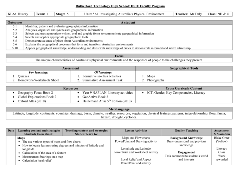
Rutherford Technology High School: HSIE Faculty Program KLA: History Term: 1 Unit: 5A1 Investigating Australia’s Physical Environment Stage: 5 Outcomes 5.1 5.2 5.3 5.4 5.5 5.6 5.10 Teacher: Mr Daly Class: 9H & O A student Identifies, gathers and evaluates geographical information Analyses, organises and synthesises geographical information Selects and uses appropriate written, oral and graphic forms to communicate geographical information Selects and applies appropriate geographical tools Demonstrates a sense of place about Australian environments Explains the geographical processes that form and transform Australian environments Applies geographical knowledge, understanding and skills with knowledge of civics to demonstrate informed and active citizenship. Focus The unique characteristics of Australia’s physical environments and the responses of people to the challenges they present. Assessment For learning: 1. Quizzes 2. Homework/Worksheets Sheet Geography Focus Book 2 Global Explorations Book 2 Oxford Atlas (2010) Geographical Tools Of learning: 1. Formative in-class activities 2. Summative Assessment Task Resources 1. Maps 2. Photographs Year 9 NAPLAN: Literacy activities GeoActive Book 2 Heinemann Atlas 5th Edition (2010) Cross Curricula Content ICT, Gender, Key Competencies, Literacy Metalanguage Latitude, longitude, continents, countries, drainage, basin, climate, weather, resources, vegetation, physical features, patterns, interrelationship, flora, fauna, hazard, drought, cyclones. Date Learning content and strategies Teaching content and strategies Students learn about: Student learn to: Maps The use various types of maps and flow charts How to locate features using degrees and minutes of latitude and longitude Calculation of the area of a feature Measurement bearings on a map Calculation local relief Lesson Activities Quality Teaching Maps and Flow charts PowerPoint and Drawing activity Background Knowledge Draw on personal and previous knowledge Longitude and Latitude PowerPoint and Worksheet activity Local Relief and Aspect PowerPoint and activity Engagement Task connected to student’s world and interests Assessment & Variation Blake Greer (Yellow) Literacy Class Work reworded Identification of the aspect of a slope Construction of a cross-section Calculation of the gradient of a slope Construction a transect Descriptions and explanations of relationships on a map Synoptic charts Photographs Interpretation of satellite images The Australian Continent Australia’s geographical dimensions: Relative size and shape, Latitude and longitude The origins of the continent: Aboriginal perspective, Geographical perspective Physical characteristics that make Australia unique Major landforms and drainage basins Patterns of: Climate, Weather, Natural resources, Vegetation Unique flora and fauna Natural hazards in Australia including: Bushfires, Droughts, Earthquakes, Floods, Storms, Tropical cyclones Cross Sections and Gradient PowerPoint and Worksheet activity Synoptic Charts PowerPoint and Worksheet activity Higher Order Thinking Analysing, synthesising, applying & evaluating Compare Australia’s size and shape with other continents and countries Geographical Dimensions PowerPoint and Worksheet Metalanguage Explicitly name and analyse knowledge Locate and recognise Australia on a world map using latitude and longitude Origins of Continent: Indigenous PowerPoint, Worksheet, Video High expectations Evidence of risk taking Origins of Continent: Geographical PowerPoint, Worksheet, Animation Explicit Quality Criteria Expectations are made explicit Explain the origins of the continent from an Aboriginal and geographical perspective Identify and represent Australia’s major physical features and patterns on a variety of maps Describe Australia’s major physical features and patterns Identify Australia’s major physical features and patterns Substantive Communication Sustain conversations about outcomes, concepts & ideas Identify Australia’s major physical features and patterns Problematic knowledge Multiple perspectives and solutions Explain the interrelationships that exist in the physical environment Metalanguage Explicitly name and analyse knowledge Explain the interrelationships that exist in the physical environment of Australia Describe the range of natural hazards in Australia Explain adaptations of flora and fauna to the Australian environment Describe the consequences of natural hazards in Australia Describe the range of natural hazards in Australia and their consequences Describe the geographical processes associated with the natural hazard At least ONE natural hazard from the list Describe the geographical above: The nature of the natural hazard in processes associated with the Australia natural hazard Describe the economic impacts Describe the environmental impacts Describe the social impacts The geographical processes involved Deep Knowledge Draw on clear and concise relationships between and among concepts Describe the economic, environmental and social impacts Investigate responses of individuals, High expectations Evidence of risk taking Background Knowledge Draw on personal and previous knowledge Deep Knowledge Draw on clear and concise relationships between and among concepts Higher Order Thinking Analysing, synthesising, applying & evaluating The impacts of the natural hazard: Economic, Environmental, Social The responsibility and responses of individuals, groups and various levels of government to the impact of the natural hazard of the natural hazard in Australia Investigate responses of individuals, community-based groups and different levels of government to the hazard to the hazard Investigate responses of communitybased groups to the hazard Cultural Knowledge Acknowledgement of a range of cultural experiences Investigate responses of different levels of government to the hazard Evaluation: Signature: ___________________ Date: _______/_______/_______


