Geology Lab Q3- Fall 2010
advertisement
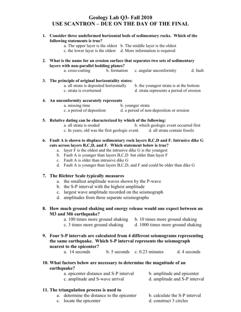
Geology Lab Q3- Fall 2010 USE SCANTRON – DUE ON THE DAY OF THE FINAL 1. Consider three undeformed horizontal beds of sedimentary rocks. Which of the following statements is true? a. The upper layer is the oldest b. The middle layer is the oldest c. the lower layer is the oldest d. More information is required 2. What is the name for an erosion surface that separates two sets of sedimentary layers with non-parallel bedding planes? a. cross-cutting b. formation c. angular unconformity d. fault 3. The principle of original horizontality states: a. all strata is deposited horizontally b. the youngest strata is at the bottom c. strata is overturned d. strata represents a period of erosion 4. An unconformity accurately represents a. missing time b. younger strata c. a period of deposition d. a period of non-deposition or erosion 5. Relative dating can be characterized by which of the following: a. all strata is eroded b. which geologic event occurred first c. In years, old was the first geologic event. d. all strata contain fossils 6. Fault A is shown to displace sedimentary rock layers B,C,D and F. Intrusive dike G cuts across layers B,C,D, and F. Which statement below is true? a. layer F is the oldest and the intrusive dike G is the youngest b. Fault A is younger than layers B,C,D but older than layer F c. Fault A is older than intrusive dike G d. Fault A is younger than layers B,C,D, and F and could be older than dike G 7. The Richter Scale typically measures a. the smallest amplitude waves shown by the P-wave b. the S-P interval with the highest amplitude c. largest wave amplitude recorded on the seismograph d. amplitudes from three separate seismographs 8. How much ground shaking and energy release would one expect between an M3 and M6 earthquake? a. 100 times more ground shaking b. 10 times more ground shaking c. 3 times more ground shaking d. 1000 times more ground shaking 9. Four S-P intervals are calculated from 4 different seismograms representing the same earthquake. Which S-P interval represents the seismograph nearest to the epicenter? a. 14 seconds b. 5 seconds c. 0.23 minutes d. 4 seconds 10. What factors below are necessary to determine the magnitude of an earthquake? a. epicenter distance and S-P interval b. amplitude and epicenter c. amplitude and S-wave arrival d. amplitude and S-P interval 11. The triangulation process is used to a. determine the distance to the epicenter c. locate the epicenter b. calculate the S-P interval d. construct 3 circles 12. The Richter scale a. is still being used today c. was used until the early 1970’s b. was replaced by the Mercalli Scale d. is based on the arrhythmic scale 13. Given the RF scale of 12:6,000, which ratio below represents measurement that would most likely appear on a topographic map? a. 1:2,000 b. 1: 500 c. 1: 50 d. 1: 5,000 14. Which statement below describes the representative fraction scale 1:24,000 a. one map inch equals 24,000 real earth inches b. one map inch equals 24,000 feet c. one map centimeter equals 24,000 meters d. one map inch equals 12 earth feet 15. Magnetic declination describes a. the angle between magnetic north and where the compass points b. the angle between geographic north and where the compass points c. the angle between geographic north and true north d. true north 16. There are ______ sections within a __________ which represents ________ miles a. 63……section……63 square b. 36……range……6 c. 36…..township/range……36 square d. 36… township….23,040 17. How many base line/meridian pairs does California contain? a. 1 b. 2 c. 3 d. 4 18. Which of the following is not a rule of contour lines? a. Contour lines never cross or divide. b. Depressions are represented by closed contour lines with hachure’s that point in the downhill direction. c. Closely spaced contour lines show steep valleys or hills. d. Contour lines which intersect streams form “V” patterns with the open V pointing up-stream. 19. Topographic gradients are determined using a. the highest elevation subtracted from the lowest elevation b. “Run” over “Rise”, where run shows the gradient c. the representative fraction scale and the “Run” d. the lowest elevation subtracted from the highest elevation divided by the “Run” 20. A topographic profile represents a. a cross-sectional view of the landscape b. a “natural” way of viewing topographic features c. can be constructed with any topographic map d. all of the above
