ARRIVAL FROM EAST
advertisement
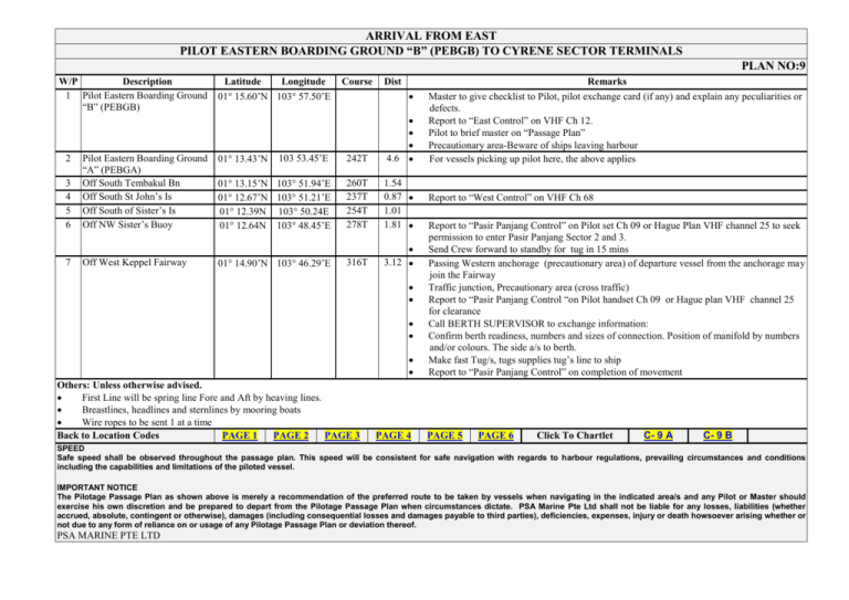
ARRIVAL FROM EAST PILOT EASTERN BOARDING GROUND “B” (PEBGB) TO CYRENE SECTOR TERMINALS PLAN NO:9 W/P Description 1 Pilot Eastern Boarding Ground “B” (PEBGB) Latitude Longitude 01 15.60’N 103 57.50’E Dist 103 53.45’E 242T 4.6 01 13.15’N 103 51.94’E 01 12.67’N 103 51.21’E 01 12.39N 103 50.24E 01 12.64N 103 48.45’E 260T 237T 254T 278T 1.54 0.87 1.01 1.81 01 14.90’N 103 46.29’E 316T 3.12 01 13.43’N 3 4 5 6 Pilot Eastern Boarding Ground “A” (PEBGA) Off South Tembakul Bn Off South St John’s Is Off South of Sister’s Is Off NW Sister’s Buoy 7 Off West Keppel Fairway 2 Course Others: Unless otherwise advised. First Line will be spring line Fore and Aft by heaving lines. Breastlines, headlines and sternlines by mooring boats Wire ropes to be sent 1 at a time Back to Location Codes PAGE 1 PAGE 2 PAGE 3 PAGE 4 Remarks Master to give checklist to Pilot, pilot exchange card (if any) and explain any peculiarities or defects. Report to “East Control” on VHF Ch 12. Pilot to brief master on “Passage Plan” Precautionary area-Beware of ships leaving harbour For vessels picking up pilot here, the above applies Report to “West Control” on VHF Ch 68 Report to “Pasir Panjang Control” on Pilot set Ch 09 or Hague Plan VHF channel 25 to seek permission to enter Pasir Panjang Sector 2 and 3. Send Crew forward to standby for tug in 15 mins Passing Western anchorage (precautionary area) of departure vessel from the anchorage may join the Fairway Traffic junction, Precautionary area (cross traffic) Report to “Pasir Panjang Control “on Pilot handset Ch 09 or Hague plan VHF channel 25 for clearance Call BERTH SUPERVISOR to exchange information: Confirm berth readiness, numbers and sizes of connection. Position of manifold by numbers and/or colours. The side a/s to berth. Make fast Tug/s, tugs supplies tug’s line to ship Report to “Pasir Panjang Control” on completion of movement PAGE 5 PAGE 6 Click To Chartlet C- 9 A C- 9 B SPEED Safe speed shall be observed throughout the passage plan. This speed will be consistent for safe navigation with regards to harbour regulations, prevailing circumstances and conditions including the capabilities and limitations of the piloted vessel. IMPORTANT NOTICE The Pilotage Passage Plan as shown above is merely a recommendation of the preferred route to be taken by vessels when navigating in the indicated area/s and any Pilot or Master should exercise his own discretion and be prepared to depart from the Pilotage Passage Plan when circumstances dictate. PSA Marine Pte Ltd shall not be liable for any losses, liabilities (whether accrued, absolute, contingent or otherwise), damages (including consequential losses and damages payable to third parties), deficiencies, expenses, injury or death howsoever arising whether or not due to any form of reliance on or usage of any Pilotage Passage Plan or deviation thereof. PSA MARINE PTE LTD C9A TOP PAGE NEXTCHARTLET C9B C9B PREVIOUS CHARTLET C9A TOP PAGE
