Identifying Plate Tectonics Lab 1-34
advertisement
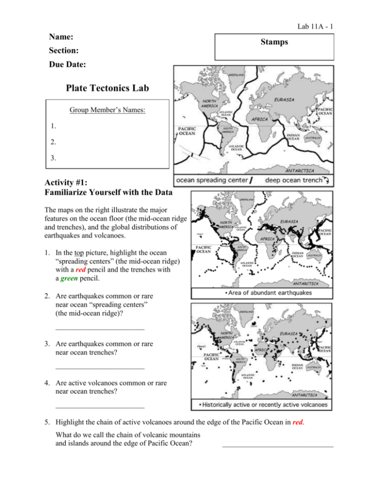
Lab 11A - 1 Name: Stamps Section: Due Date: Plate Tectonics Lab Group Member’s Names: 1. 2. 3. Activity #1: Familiarize Yourself with the Data The maps on the right illustrate the major features on the ocean floor (the mid-ocean ridge and trenches), and the global distributions of earthquakes and volcanoes. 1. In the top picture, highlight the ocean “spreading centers” (the mid-ocean ridge) with a red pencil and the trenches with a green pencil. 2. Are earthquakes common or rare near ocean “spreading centers” (the mid-ocean ridge)? ________________________ 3. Are earthquakes common or rare near ocean trenches? ________________________ 4. Are active volcanoes common or rare near ocean trenches? ________________________ 5. Highlight the chain of active volcanoes around the edge of the Pacific Ocean in red. What do we call the chain of volcanic mountains and islands around the edge of Pacific Ocean? ______________________________ Activity #2: Density of Continental and Oceanic “Crust” Lab 11A - 2 If another group is doing the experiment, begin on Activity #3, and do Activity #2 when they are finished. In this experiment, you will measure the density of the rock making up the continental crust and oceanic crust (the “crust” is the top part of the lithosphere, the solid outer layer of the Earth). 6. What kind of rock is continental crust made of? ________________________ 7. What kind of rock is oceanic crust made of? ________________________ 8. Identify the two rock samples. In other words, which one is basalt? Which is granite? How can you tell them apart? 9. Measure the mass (weight) of each rock sample in grams and record them in the table below. 10. Measure the volume (size) of each rock sample in cubic centimeters (cm3) and record them in the table below. Procedure: Fill the beaker up to the 300-ml line. Put the rock in the beaker. 1 milliliter (ml) is equal to 1 cubic centimeter (cm3) Read off the level of the water in the beaker. The volume of the rock is the level of the water in the beaker minus 300 ml. (You might pour the water above the 300-ml line into the graduated cylinder – the tall, thin container – to make a more precise estimate of the volume of the rock.) Remove the rock from the beaker and dry it off. Mass (grams) Volume (cm3) Density (g/cm3) Basalt Granite 11. Using your measurements, calculate the density of each rock. Show your work in the space provided in the table above. Circle your answers. 12. Which kind of crust has a higher density, continental crust or oceanic crust? ________________________ Lab 11A - 3 Activity #3: Case Studies in Plate Tectonics Hint: A variety of figures in your textbook and notes may be useful for answering these questions. I recommend figure 2.10 on p. 44 in particular. Figure 2.22 on p. 58 is useful for the first question, and figure 2.20 on p. 55 and figure 2.23 on p. 59 are also useful. 13. At the mid-ocean ridge, are the plates moving apart or towards one another? Mt. Everest, the world’s tallest mountain, is found in the Himalayas, the tall mountains north of India. _________________________ 14. Outline the mid-ocean ridge in red in the figure below. Put red arrows on the map near the mid-ocean ridge showing the directions in which the Earth’s crust is moving. 15. Draw a green line through the mountains representing the place where the Indian plate is meeting the Eurasian plate. India 16. Why are Mt. Everest and the Himalayas so tall? Explain how and why the motion of the plates creates them. At the location of Mt. Everest, the plates are moving Away From / Towards one another. Neither plate subducts under the other plate and down into the mantle because both plates are made of _____________________ which has a density that is much ___________________ than the density of Basalt / Granite / the Mantle, so neither plate can sink down into it. Since the plates cannot go Up / Down when they smash together, the only direction the plates can go is Up / Down, which creates _________________________________________________. 17. Label the figure on the right showing the plates near Mt. Everest and the Himalayas. ● Put an arrow on each plate showing its direction. ● Write “basalt” or “granite” on each plate. ● Label the mantle, and draw arrows in it showing the direction in which the magma is flowing. ● Label Mt. Everest and the Himalayas. Lab 11A - 4 18. Outline the trench in green in the figure below. Put green arrows on the map on both sides of the trench showing the directions in which the Earth’s crust is moving. 19. At the location of the Mariana Trench, are the plates moving apart or towards one another? __________________________ 20. Why is the plate on the right (the eastern plate), subducting at the trench? The Mariana Trench, the deepest place in the world, is found next to a chain of volcanic islands called the Mariana Islands. Both plates are made of ___________________________, but the plate on the right is Younger / Older than the plate on the left, so it has a ___________________________ density than the plate on the left, because______________________________________________________________ ____________________________________________________________________ 21. What is a trench? _____________________________________________________ How or why does the collision of these two plates create a trench? 22. Why are there islands next to the Mariana Trench? Explain how and why the motion of the plates creates them. 23. Label the figure on the right showing the plates near the Mariana Trench. ● Put an arrow on each plate showing its direction. ● Write “basalt” or “granite” on each plate. ● Label the mantle, and draw arrows in it showing the direction in which the magma is flowing. ● Write “melting” in red where a plate is melting, and show the lava rising up through the other plate. ● Label the Mariana Trench and the Mariana Islands. Lab 11A - 5 24. Outline the mid-ocean ridge in red, the trench in green, and the (transform) faults in blue in the figure below. Put red arrows on the map near mid-ocean ridge showing the directions in which the Earth’s crust is moving, and put green arrows near the trench showing the directions in which the Earth’s crust is moving. 25. At the trench off the coast of Northern California, Oregon, and Washington, are the plates moving apart or towards one another? __________________________ 26. Why is the plate on the left (the western plate) subducting at the trench? Mount St. Helens The plate on the left is made of ___________________________, and the plate on the right is made of San Francisco ___________________________, Los Angeles When they meet, the plate on the left dives below the plate on the right because: 27. Why W are there so many volcanoes (e.g., Mount St. Helens) in the Pacific Northwest near the coast and the trench? Explain how and why the motion of the plates creates them. 28. Label the figure on the right showing the plates near the trench in the Pacific Northwest and Mount St. Helens. ● Put an arrow on each plate showing its direction. ● Write “basalt” or “granite” on each plate. ● Label the mantle, and draw arrows in it showing the direction in which the magma is flowing. ● Write “melting” in red where a plate is melting, and show the lava rising up through the other plate. ● Label the trench and Mount St. Helens. Lab 11A - 6 29. Outline the mid-ocean ridge in red and transform faults in blue in the figure below. Put red arrows on the map by the mid-ocean ridge showing the directions in which the Earth’s crust is moving. 30. At the mid-ocean ridge, are the plates moving apart or towards one another? __________________________ Mexico (mainland) A 31. Why are the plates moving apart or towards one another? Baja California B 32. Label the figure on the right showing the plates along the dotted line A-B. ● Put an arrow on each plate showing its direction. ● Write “basalt” or “granite” in appropriate places on each plate. ● Label the mantle, and draw arrows in it showing the direction in which the magma is flowing. ● Label the mid-ocean ridge, Baja California, and the mainland of Mexico. 33. Is the distance between the mainland of Mexico and Baja California getting larger, smaller, or staying the same? __________________________ 34. It is sometimes said that after a big earthquake, California will “fall into the ocean.” When Southern California and Baja California finally break away from North America, will they (the land) sink below sea level? Why or why not? (Hint: Discuss the layers of the Earth: lithosphere/crust, mantle.) Lab 11A - 7 Activity #4: Sediment Cores and Plate Tectonics A sediment core was obtained from 15oN, 150oW. The location labeled “1st” along the midocean ridge is the place where the basalt cooled from lava into solid ocean crust and the 1st layer of sediments began piling up on the new ocean floor. The location labeled “3rd” is the current location of the sediments. The arrow shows the motion of the Pacific plate over time. 3rd Ridge 2nd 1st Sediment Core Today Sediment Core Equator 20 mya Ridge MOR Siliceous Ooze 100 1st 2nd 200 28 mya 300 400 Calcareous Ooze depth below seafloor (meters) 0 Red Clay 3rd Ocean Crust 42 mya Basalt 35. Which kind of sediment piled up first? second? third? Label the core accordingly. (In other words, write 1st, 2nd, & 3rd next to the sediments of the core.) Don’t forget to answer this question! The basalt is not a layer of sediments. What is it? Lab 11A - 8 All 3 kinds of sediments (calcareous ooze, red clay, and siliceous ooze) fall to the ocean bottom everywhere in the ocean, so ocean sediments are mixtures of different sediments. However, often one kind of sediment dominates. In other words, more of one kind of sediment reaches the bottom than either of the other two kinds of sediments in different places on the ocean floor. 36. Where did the calcareous ooze layer build up? The Equator / The Mid-Ocean Ridge / Near Hawaii Under what conditions did the calcareous ooze layer build up? Beneath (A)_____________ surface water Possible Answers A: Warm, Cold B: Not Too Deep, Somewhat Deep, Very Deep where the ocean was (B)________________________________. Why is a lot of calcareous ooze able to reach the ocean floor at this location and under these conditions? Discuss BOTH water temperature AND depth. Why does very little of siliceous ooze reach the ocean floor at this location and under these conditions? Why does very little red clay reach the ocean floor at this location and under these conditions? 37. Where did the siliceous ooze layer build up? The Equator / The Mid-Ocean Ridge / Near Hawaii Under what conditions did the siliceous ooze layer build up? Beneath (A)_____________ surface water where the ocean was (B)________________________________. Why is a lot of siliceous ooze able to reach the ocean floor at this location and under these conditions? Discuss BOTH water temperature AND depth. Why does very little of calcaerous ooze reach the ocean floor at this location and under these conditions? Why does very little red clay reach the ocean floor at this location and under these conditions? Lab 11A - 9 38. Where did the red clay layer build up? The Equator / Mid-Ocean Ridge / Near Hawaii Under what conditions did the red clay layer build up? Where the ocean was (B)____________________________. Why is red clay the only kind of sediment that can build up at this location and under these conditions? 39. Why is the layer of siliceous ooze so much thicker than the layer of calcareous ooze? In other words, why are more silica shells sinking to and reaching the ocean bottom at location #2 than the number of calcium-carbonate shells that are sinking to and reaching the ocean bottom at location #1? 40. Why is the layer of red clay so much thinner than the other two layers? In other words, why does very little red clay sink to and reach the ocean bottom in location #3? 41. The sediments found in this sediment core are evidence that supports the theory of plate tectonics. To see why, suppose that the ocean floor did not move away from the midocean ridge. (In other words, suppose that the theory of plate tectonics was incorrect.) In this case, what would the sediment core dug up from location #3 look like? In other words, what kind of sediments would we have found there? Explain your reasoning. The fact that the sediments at location #3 do not match those you described in your answer to the previous question demonstrates that the ocean floor has not remained in one spot; they demonstrate that the ocean floor has moved. More than that, the sequence of the sediments in the core actual verifies that the sea floor is moving away from the mid-ocean ridge. Lab 11A - 10
