Table A1 - List of locations surveyed Name and coordinates of
advertisement

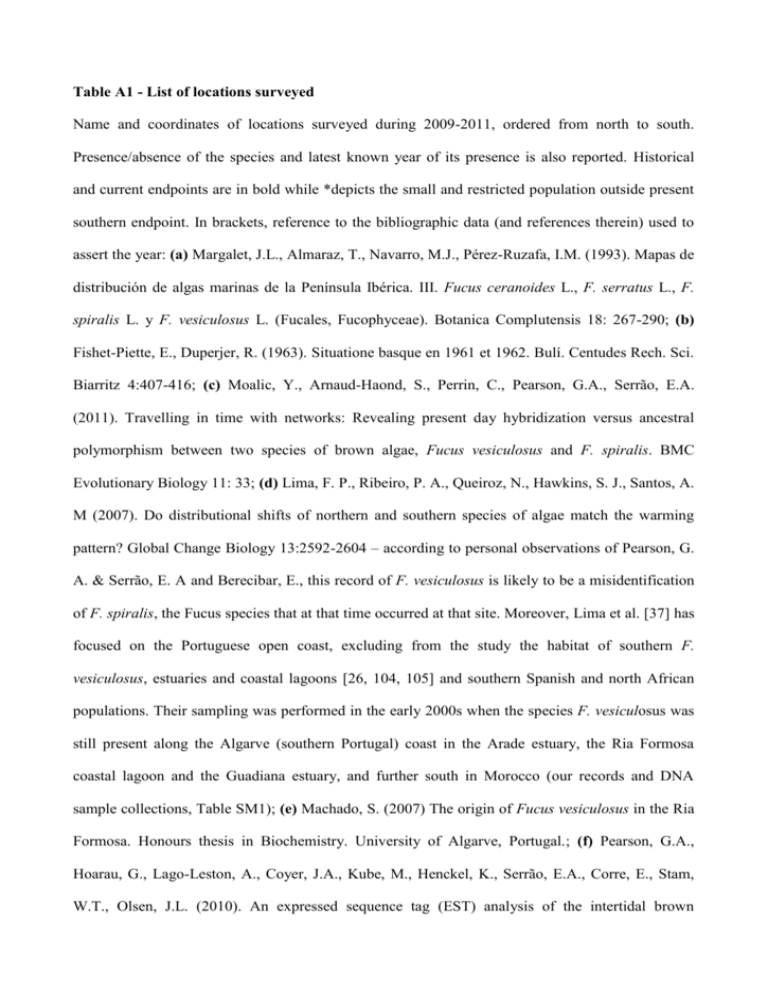
Table A1 - List of locations surveyed Name and coordinates of locations surveyed during 2009-2011, ordered from north to south. Presence/absence of the species and latest known year of its presence is also reported. Historical and current endpoints are in bold while *depicts the small and restricted population outside present southern endpoint. In brackets, reference to the bibliographic data (and references therein) used to assert the year: (a) Margalet, J.L., Almaraz, T., Navarro, M.J., Pérez-Ruzafa, I.M. (1993). Mapas de distribución de algas marinas de la Península Ibérica. III. Fucus ceranoides L., F. serratus L., F. spiralis L. y F. vesiculosus L. (Fucales, Fucophyceae). Botanica Complutensis 18: 267-290; (b) Fishet-Piette, E., Duperjer, R. (1963). Situatione basque en 1961 et 1962. Bulí. Centudes Rech. Sci. Biarritz 4:407-416; (c) Moalic, Y., Arnaud-Haond, S., Perrin, C., Pearson, G.A., Serrão, E.A. (2011). Travelling in time with networks: Revealing present day hybridization versus ancestral polymorphism between two species of brown algae, Fucus vesiculosus and F. spiralis. BMC Evolutionary Biology 11: 33; (d) Lima, F. P., Ribeiro, P. A., Queiroz, N., Hawkins, S. J., Santos, A. M (2007). Do distributional shifts of northern and southern species of algae match the warming pattern? Global Change Biology 13:2592-2604 – according to personal observations of Pearson, G. A. & Serrão, E. A and Berecibar, E., this record of F. vesiculosus is likely to be a misidentification of F. spiralis, the Fucus species that at that time occurred at that site. Moreover, Lima et al. [37] has focused on the Portuguese open coast, excluding from the study the habitat of southern F. vesiculosus, estuaries and coastal lagoons [26, 104, 105] and southern Spanish and north African populations. Their sampling was performed in the early 2000s when the species F. vesiculosus was still present along the Algarve (southern Portugal) coast in the Arade estuary, the Ria Formosa coastal lagoon and the Guadiana estuary, and further south in Morocco (our records and DNA sample collections, Table SM1); (e) Machado, S. (2007) The origin of Fucus vesiculosus in the Ria Formosa. Honours thesis in Biochemistry. University of Algarve, Portugal.; (f) Pearson, G.A., Hoarau, G., Lago-Leston, A., Coyer, J.A., Kube, M., Henckel, K., Serrão, E.A., Corre, E., Stam, W.T., Olsen, J.L. (2010). An expressed sequence tag (EST) analysis of the intertidal brown seaweeds Fucus serratus (L.) and F. vesiculosus (L.) (Heterokontophyta, Phaeophyceae) in response to abiotic stressors. Marine Biotechnology, 12:195-213; (g) Perrin, C., Daguin, C., Van de Vliet, M., Engel, C.R., Pearson, G.A., Serrão, E.A. (2007). Implications of mating system for genetic diversity of sister algal species: Fucus spiralis and Fucus vesiculosus (Heterokontophyta, Phaeophyceae). European Journal of Phycology. 42: 219-230; (h) Coyer JA, Hoarau G, Costa JF, Hogerdijk B, Serrão EA, Billard E, Valero M, Pearson GA, Olsen JL (2011). Evolution and diversification within the intertidal brown macroalgae Fucus spiralis/F. vesiculosus species complex in the North Atlantic. Molecular Phylogenetics and Evolution 58: 283-296; (i) Benhissoune, S., Boudouresque, C.-F., Verlaque, M. (2002). A checklist of the seaweeds of the Mediterranean and Atlantic Coasts of Morocco. II. Phaeophyceae. Botanica Marina 45: 217–230. (k) Kazzaz, M., Riadi, H. (1998). Inventaire bibliographique des algues benthiques du littoral marocain I, Chlorophyceae et Phaeophyceae. Acta botánica malacitana, 23: 23-41; (j) Russel, G., Hockin, D. C. (1988). The Seaweeds of the lagoon and Khnifiss the Tarfaya coast. In : Dakki M. & Ligny W. for (Eds): The Lagoon and Its Surrounding Khnifiss environment (Province of La'youne, Morocco). Trav. Inst. Sci., Mem. Occasional Papers, p. 37 to 40; (l) Bergier, P. (2009). Où voir les oiseaux dans le Sahara Atlantique marocain Go-South Bull. 6, 1-71. Location Coordinates - Lat, Long Presence Last recorded /absence (reference to literature or obser. listed in the legend) Hondarribia 43°22'7.27"N, 1°47'32.00"W Absent never recorded San Sebastian-Playa de la Concha 43°19'8.48"N, 1°59'6.01"W Absent 1951 (a) San Sebastian- Playa de Ondarreta 43°19'2.42"N, 2°0'16.59"W Absent 1951 (a) Zarautz 43°17'15.21"N, 2°10'39.11"W Absent 1960 (a, b) Getaria 43°18'2.25"N, 2°12'3.84"W Absent 1960 (a, b) Zumaia 43°17'51.98"N, 2°15'2.30"W Absent 1974 (a) Bermeo 43°25'10.93"N, 2°43'14.26"W Absent 1987 (a) Plencia 43°24'15.94"N, 2°57'2.74"W Absent 1988 (a,) El Abra 43°19'35.47"N, 3° 1'3.28"W Absent 1987 (a) Castro-Urdiales 43°23'0.50"N, 3°13'2.03"W Absent 1960 (a, b) Colindres 43°23'36.63"N, 3°27'50.15"W Present 2009-2011 Santander- El Puntal 43°27'58.81"N, 3°45'58.91"W Present 2009-2011 Suances 43°25'30.44"N, 4° 1'56.96"W Present 2009-2011 Cóbreces 43°23'43.35"N, 4°13'22.79"W Present 2009-2011 San Vincente della Barquera 43°23'13.26"N, 4°23'59.47"W Present 2009-2011 La Franca 43°23'37.40"N, 4°34'17.76"W Present 2009-2011 Llanes 43°26'11.13"N, 4°50'9.08"W Present 2009-2011 San Martin de Mar 43°31'21.58"N, 5°23'30.98"W Present 2009-2011 Piles 43°32'39.59"N, 5°38'42.44"W Present 2009-2011 Gijón 43°32'42.21"N, 5°39'39.97"W Present 2009-2011 Perán 43°35'0.36"N, 5°45'20.91"W Present 2009-2011 Arnao 43°34'39.87"N, 5°58'48.47"W Present 2009-2011 Concha de Artedo 43°33'45.32"N, 6°11'2.88"W Present 2009-2011 Luarca 43°32'32.02"N, 6°32'4.33"W Present 2009-2011 Puerto de Vega 43°33'56.86"N, 6°38'43.42"W Present 2009-2011 Figueras 43°32'15.53"N, 7° 1'24.60"W Present 2009-2011 Castropol 43°31'43.95"N, 7° 1'47.28"W Present 2009-2011 Foz 43°33'58.29"N, 7°15'18.59"W Present 2009-2011 San Cibrao 43°41'39.81"N, 7°26'16.51"W Present 2009-2011 Viveiro 43°39'47.21"N, 7°35'52.83"W Present 2009-2011 Area Longa 43°43'49.36"N, 7°40'54.32"W Present 2009-2011 Ortigueira 43°40'59.56"N, 7°51'18.87"W Present 2009-2011 Cedeira 43°39'34.12"N, 8°3'22.87"W Present 2009-2011 Ferrol 43°29'1.61"N, 8°12'43.54"W Present 2009-2011 Pasaxe do Pedrido 43°19'23.45"N, 8°12'27.92"W Present 2009-2011 La Coruña 43°22'10.01"N, 8°24'40.55"W Present 2009-2011 Balarés 43°14'31.96"N, 8°56'42.07"W Present 2009-2011 Arou 43°11'5.83"N, 9°6'25.28"W Present 2009-2011 Ria de Lires 43° 0'3.57"N, 9°15'34.62"W Present 2009-2011 Muros 42°46'25.14"N, 9° 3'10.58"W Present 2009-2011 Pesqueira 42°36'51.53"N, 8°52'57.29"W Present 2009-2011 Pontevedra 42°25'39.87"N, 8°39'9.44"W Present 2009-2011 Canido 42°11'45.17"N, 8°47'48.50"W Present 2009-2011 La Guardia 41°53'55.84"N, 8°52'32.11"W Present 2009-2011 Caminha 41°53'0.23"N, 8°51'14.02"W Present 2009-2011 Montedor 41°44'46.71"N, 8°52'39.37"W Present 2009-2011 Viana do Castelo 41°41'56"N, 8°51'12"W Present 2009-2011 Viana do Castelo - Rio Lima 41°41'47.82"N, 8°51'4.64"W Present 2009-2011 Amorosa 41°38'44.32"N, 8°49'31.14"W Present 2009-2011 Apulia 41°28'53.61"N, 8°46'36.76"W Present 2009-2011 Póvoa do Varzim 41°22'30.22"N, 8°45'53.09"W Present 2009-2011 Mindelo 41°18'37.30"N, 8°44'30.27"W Present 2009-2011 Porto 41° 8'49.85"N, 8°40'3.56"W Present 2009-2011 Ria de Aveiro 40°39'40.24"N, 8°43'44.64"W Present 2009-2011 Figueira da Foz 40° 8'45.69"N, 8°50'28.84"W Present 2009-2011 Alcochete 38°45'38.99"N, 8°56'28.43"W Present 2009-2011 Vila Nova de Milfontes 37°43'21.68"N, 8°47'10.81"W Absent 2001 (c) Ingrina 37° 2'46.36"N, 8°52'46.78"W Absent 2001-2006 (d) Portimao 37° 8'30.63"N, 8°31'48.02"W Absent 2005 (e) Faro-Ria Formosa 37° 0'40.81"N, 7°59'28.00"W Absent 2008 (f) Tavira 37° 7'28.26"N, 7°38'35.82"W Absent 2001 (g) Ayamonte 37°12'48.49"N, 7°24'14.03"W Absent 2008 (h) El Rompido 37°13'0.15"N, 7° 7'36.65"W Absent 1991 (a) Sanlúcar de Barrameda 36°47'23.88", 6°21'7.09"W Absent 1991 (a) Cádiz-La Caleta 36°31'58.79"N, 6°18'26.27"W Absent 1977 (a) Cádiz-Playa de La Victoria 36°30'16.63"N, 6°16'42.84"W Absent 1977 (a) Cádiz-Puerto Real 36°31'27.53"N, 6°10'52.61"W Present 2009-2011* Tarifa 36° 0'28.39"N, 5°36'24.72"W Absent 1988 (a) Tanger 35°46'58.87"N, 5°48'13.52"W Absent 1962 (i) Azilah 35°27'58.29"N, 6° 2'23.99"W Absent 2002 (i) Lixus 35°12'8.67"N, 6°6'47.89"W Absent 2001 (c) Kenitra 34°15'58.47"N, 6°35'18.16"W Absent 2002 (i) Rabat 34° 1'45.29"N, 6°49'46.85"W Absent 1963 (i, k) Temara 33°56'50.28"N, 6°56'1.41"W Absent 2002 (i) Casablanca 33°36'33.25"N, 7°39'1.14"W Absent 1962 (i) El Jadida 33°15'10.19"N, 8°30'0.23"W Absent 1989 (i, k) Oualidia 32°44'34.00"N, 9°2'20.53"W Absent 1962 (i) Safi 32°18'51.11"N, 9°15'1.89"W Absent 1962 (i) Essaouira 31°30'36.72"N, 9°46'13.85"W Absent 1962 (i) Agadir 30°25'20.99"N, 9°36'57.25"W Absent never reported El Ouatia 28°28'34.09"N, 11°21'21.08"W Absent never reported Khnifiss Lagoon 27°59'40.82"N,12°16'33.98"W Absent 1985-1988 (j, l) Boujdour 26° 7'23.21"N, 14°30'0.18"W Absent never reported Daklha 23°41'58.80"N, 15°55'39.43"W Absent never reported


