eost2014EO440001-sup-0001-f01
advertisement
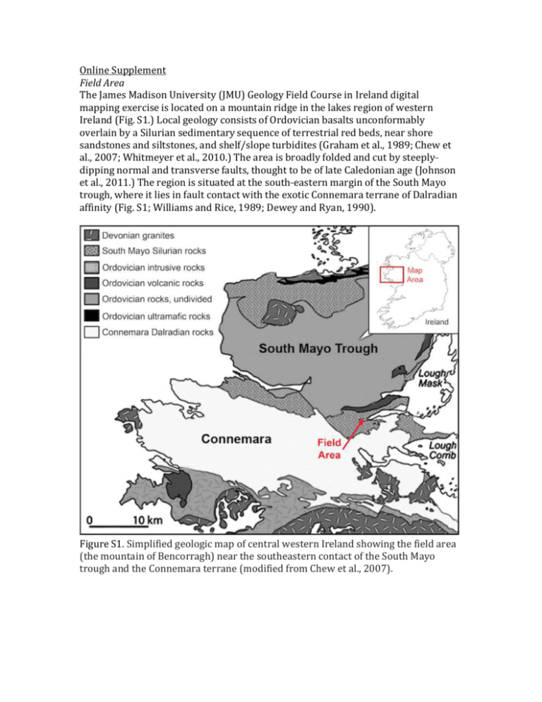
Online Supplement Field Area The James Madison University (JMU) Geology Field Course in Ireland digital mapping exercise is located on a mountain ridge in the lakes region of western Ireland (Fig. S1.) Local geology consists of Ordovician basalts unconformably overlain by a Silurian sedimentary sequence of terrestrial red beds, near shore sandstones and siltstones, and shelf/slope turbidites (Graham et al., 1989; Chew et al., 2007; Whitmeyer et al., 2010.) The area is broadly folded and cut by steeply-­­ dipping normal and transverse faults, thought to be of late Caledonian age (Johnson et al., 2011.) The region is situated at the south-­­eastern margin of the South Mayo trough, where it lies in fault contact with the exotic Connemara terrane of Dalradian affinity (Fig. S1; Williams and Rice, 1989; Dewey and Ryan, 1990). Figure S1. Simplified geologic map of central western Ireland showing the field area (the mountain of Bencorragh) near the southeastern contact of the South Mayo trough and the Connemara terrane (modified from Chew et al., 2007). Figure S2. Composite geologic map (shown as point data) of Bencorragh mountain compiled from 6 years of student field data during the JMU Field course digital mapping exercise. White box shows approximate area of Figure 1 in the main text. Assessment Data The tables below summarize six years of assessment data on the digital mapping exercise at the JMU Geology Field Course in Ireland – a six credit summer capstone field experience. (http://www.jmu.edu/geology/irelandfieldcourse.shtml) Table S1. 1 2 3 4 Nonexistent Very little Moderate Considerable Extensive Mean 2.15 My prior feelings specific to this exercise were Great discomfort Slightly apprehensive Neutral At--‐ease and comfortable Highly motivated 2.97 My prior skill level with this exercise was Completely unskilled Basic Competent Skilled Expert 2.34 My knowledge gains from this exercise were Nonexistent Very little Moderate Considerable Extensive 3.77 My feelings after this exercise were Great discomfort Slightly apprehensive Neutral At--‐ease and comfortable Highly motivated 3.66 I found this exercise to be: Not valuable at all Only slightly valuable Moderately valuable Useful Essential 4.18 My skill level after this exercise was Completely unskilled Basic Competent Skilled Highly skilled 3.49 My overall learning from this exercise was Nonexistent Trivial Moderate Considerable Extensive 3.77 My prior experience with ArcGIS was: 5 Table S1. Assessment data for six years of digital mapping exercises; mean of responses, n=167. Significant gains were recorded in Feelings, Skill Level, and Knowledge. Assessment template from Pyle (2009). Table S2. The exercise shows the ease of digital mapping. The best part was using ArcGIS instead of paper mapping. The exercise uses modern technology to map in a way that prepares me for what I’d see in a future job. The best part was using GIS to map, but more instruction in GIS would have helped. I really enjoyed this project & like the fact that it's using modern technology --‐ a skill that can be used in one's career. I really enjoyed the GIS portion, but it seemed rushed. I thought the digital technology made things much more simple The iPad was useful. It helped speed the mapping process so that better data could be collected. Working with the iPad and GIS is overall a great experience, especially in a century of technology advances in every field. I am not a computer person, but this is a really great exercise. Table S2. Example comments about the digital mapping exercise from students in the James Madison University Geology Field Course in Ireland. Acknowledgements Many thanks to the students and faculty that participated in the JMU Ireland Field Course from 2009 -­­ 2014. This manuscript was improved by comments from 3 anonymous reviewers. The work highlighted was funded in part by NSF grant DUE 1022782 and the JMU College of Science and Mathematics. References Chew, D.M., Graham, J.R., and Whithouse, M.J., 2007, U-­­Pb zircon geochronology of plagiogranites from the Lough Nafooey (= Midland Valley) arc in western Ireland: Constraints on the onset of the Grampian orogeny: Journal of the Geological Society, v. 164, p. 747–750. Dewey, J.F., and Ryan, P.D., 1990, The Ordovician evolution of the South Mayo trough, western Ireland: Tectonics, v. 9, p. 887–903. Graham, J.R., Leake, B.E., and Ryan, P.D., 1989, The geology of South Mayo, western Ireland: Edinburgh, Scottish Academic Press, 75 p. Johnson, E.A., Sutherland, S., Logan, M.A.V., Samson, S.D., and Feely, M., 2011, Emplacement Conditions of a Porphyritic Felsite Dyke and Timing of Motion Along the Coolin Fault at Ben Levy, Co. Galway, Irish Journal of Earth Sciences, v. 29, p. 1-­­ 13, doi: 10.3318/IJES.2011.29.1 Pyle, E., 2009, A framework for the evaluation of field camp experiences, in Whitmeyer, S.J., Mogk, D., and Pyle, E.J., eds., Field Geology Education: Historical Perspectives and Modern Approaches: Geological Society of America Special Paper 461, p. 341-­­356. Whitmeyer, S.J., Nicoletti, J., and De Paor, D.G., 2010, The Digital Revolution in Geologic Mapping: GSA Today, v. 20, p. 4-­­10, doi: 10.1130/GSATG70A.1. Williams, D.M., and Rice, A.H.N., 1989, Low-­­angle extensional faulting and the emplacement of the Connemara Dalradian, Ireland: Tectonics, v. 8, p. 417–428.
