Karst Landscapes: Formation, Features & Groundwater
advertisement

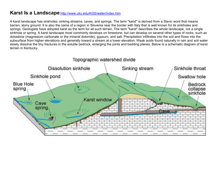
Karst Is a Landscape http://www.uky.edu/KGS/water/index.htm A karst landscape has sinkholes, sinking streams, caves, and springs. The term "karst" is derived from a Slavic word that means barren, stony ground. It is also the name of a region in Slovenia near the border with Italy that is well known for its sinkholes and springs. Geologists have adopted karst as the term for all such terrain. The term "karst" describes the whole landscape, not a single sinkhole or spring. A karst landscape most commonly develops on limestone, but can develop on several other types of rocks, such as dolostone (magnesium carbonate or the mineral dolomite), gypsum, and salt. Precipitation infiltrates into the soil and flows into the subsurface from higher elevations and generally toward a stream at a lower elevation. Weak acids found naturally in rain and soil water slowly dissolve the tiny fractures in the soluble bedrock, enlarging the joints and bedding planes. Below is a schematic diagram of karst terrain in Kentucky. Introduction to Karst Groundwater An aquifer is any body of bedrock, or other earth material, from which a well or spring produces useable quantities of groundwater. All potable groundwater originates as precipitation. The rain or snowmelt percolates into the ground, and flows through the pores and fractures in the bedrock, to ultimately discharge from the aquifer and once again become surface water. Schematic drawing of the common types of aquifer porosity found in Kentucky: unconsolidated intergranular, fractured bedrock, and solutionenhanced limestone. Solution-enhanced porosity begins as fractured bedrock in Kentucky. Many important aquifers are composed of granular materials such as loose sand and gravel or weakly cemented bedrock (see figure above). Groundwater flow in these aquifers is through the pores or spaces between the grains of sand or gravel, or through narrow fractures in solid bedrock, and is usually very slow. How quickly the water flows is partly dependent on how big the pores are, how interconnected the pores or fractures are, and how much energy (head or water pressure) is available to move the water through the aquifer. The small pore openings act as a filter, physically or chemically removing most bacteria, viruses, and polluting chemicals within a few tens to hundreds of feet. In shallow granular aquifers the water table mimics the land surface, and the slope of the land can often predict the direction of groundwater flow. Springs occur along creeks and rivers where the water table meets the land surface. Artesian springs occur where impermeable rocks, such as shale, underlie and cover (confine) most of the aquifer. The impermeable rock restricts the direction of groundwater flow and can direct flow in a confined aquifer to discharge many miles from where it started out. Recharge and discharge occurs where the confining unit is missing.


