Adapted Future Landscapes-from aspiration to inspiration.
advertisement
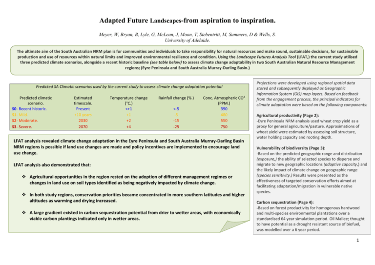
Adapted Future Landscapes-from aspiration to inspiration. Meyer, W, Bryan, B, Lyle, G, McLean, J, Moon, T, Siebentritt, M, Summers, D & Wells, S. University of Adelaide. The ultimate aim of the South Australian NRM plan is for communities and individuals to take responsibility for natural resources and make sound, sustainable decisions, for sustainable production and use of resources within natural limits and improved environmental resilience and condition. Using the Landscape Futures Analysis Tool (LFAT,) the current study utilised three predicted climate scenarios, alongside a recent historic baseline (see table below) to assess climate change adaptability in two South Australian Natural Resource Management regions; (Eyre Peninsula and South Australia Murray-Darling Basin.) Predicted SA Climatic scenarios used by the current study to assess climate change adaptation potential Predicted climatic scenario. S0- Recent historic. S1- Mild. S2- Moderate. S3- Severe. Estimated timescale. Present +10 years 2030 2070 Temperature change (°C.) <+1 +1 +2 +4 Rainfall change (%.) <-5 -5 -15 -25 Conc. Atmospheric CO2 (PPM.) 390 480 550 750 LFAT analysis revealed climate change adaptation in the Eyre Peninsula and South Australia Murray-Darling Basin NRM regions is possible if land use changes are made and policy incentives are implemented to encourage land use change. LFAT analysis also demonstrated that: Agricultural opportunities in the region rested on the adoption of different management regimes or changes in land use on soil types identified as being negatively impacted by climate change. In both study regions, conservation priorities became concentrated in more southern latitudes and higher altitudes as warming and drying increased. A large gradient existed in carbon sequestration potential from drier to wetter areas, with economically viable carbon plantings indicated only in wetter areas. Projections were developed using regional spatial data stored and subsequently displayed as Geographic Information System (GIS) map layers. Based on feedback from the engagement process, the principal indicators for climate adaptation were based on the following components: Agricultural productivity (Page 2): -Eyre Peninsula NRM analysis used wheat crop yield as a proxy for general agriculture/pasture. Approximations of wheat yield were estimated by assessing soil structure, water holding capacity and rooting depth. Vulnerability of biodiversity (Page 3): -Based on the predicted geographic range and distribution (exposure,) the ability of selected species to disperse and migrate to new geographic locations (adaptive capacity,) and the likely impact of climate change on geographic range (species sensitivity.) Results were presented as the effectiveness of targeted conservation efforts aimed at facilitating adaptation/migration in vulnerable native species. Carbon sequestration (Page 4): -Based on forest productivity for homogenous hardwood and multi-species environmental plantations over a standardised 64 year simulation period. Oil Mallee; thought to have potential as a drought resistant source of biofuel, was modelled over a 6 year period. 1 Agricultural productivity (Eyre Peninsula Wheat productivity): Simulated average Wheat yield (Kg/Ha.) S1 S0 S1- Moderate increase in Wheat production due to increased temperature and CO2 and limited reduction in rainfall. S2- Projected climatic conditions for 2030 assuming significant mitigating actions are taken; noticeable reductions in yield in low rainfall zones. Additional factors begin to have an effect; coarser textured soils retain higher yields compared to finer soils. S3- Large yield reductions across all low rainfall areas. In medium rainfall areas with coarse textured soil, yields marginally increased whereas, areas with fine soil showed 10-30% yield reductions. In high rainfall areas, the trend continued; with coarse soils indicating 0-20% increase and fine soils indicating a 0-20% decrease in yield respectively. The simulations suggested that the opportunities and options available for climate change adaptation would vary across the Eyre Peninsula and within low, medium and high rainfall regions. Opportunities within the region were predicted to rest on the adoption of different management regimes or changes in land use on soil types identified as being negatively impacted by climate change. S2 S3 2 Biodiversity: Spatial conservation priorities for vulnerable species. Eyre Peninsula NRM. Top 5% priority. 90-95% priority. 80-90% priority. 60-80% priority. Lowest 60% priority. NRM boundary SA Mainland. SA Murray-Darling Basin NRM. In both Eyre Peninsula and SA Murray-Darling Basin conservation priorities became increasingly concentrated in Southern latitudes and higher altitudes; areas with typically lower average temperatures and higher average rainfall. The simulations did however reveal that targeting vulnerable species did have an associated trade-off between a focus on sensitive species and appropriate representation of other species. The results were thought to have significant practical implications for conservation agencies, as they provide an effective, quantitative, repeatable and geographically transferable methodology to prioritise conservation and restoration under climate change. 3 Carbon sequestration: 5 4 8 3 2 S0 S1 S2 S3 Climate scenario. Hardwood plantation (EP) Environmental plantation (EP) Hardwood plantation (SAMDB) Environmental plantation (SAMDB) Mean Oil Mallee annual growth rate (Tonnes/Ha) Average annual carbon sequestration (Tonnes CO2 -e/ha/year) 6 Similar spatial patterns were observed across both study-site regions, with higher productivity and carbon sequestration rates in areas of greater rainfall, typically the more Southern latitudes and higher altitudes. Nonetheless, all three land uses displayed high spatial variability in both regional study areas. Average carbon sequestration rates decreased substantially for hardwood plantations and environmental plantations in the SA MBD under increased warming and drying with even more substantial reductions in low rainfall areas (See left.) Despite, on average, reductions in Oil Mallee growth rates and yield in both regions, areas with higher rainfall totals indicated increased Oil Mallee productivity in the Eyre Peninsula. The lack of similar increased yield patterns in wetter areas of the SA Murray-Darling Basin was attributed to likely differences in soil type and depth (See below.) 7 6 5 4 3 2 S0 S1 S2 S3 Climate scenario. The results demonstrated the spatial variability of tree growth and carbon sequestration. They highlighted the influence of water balance and soil type in biomass production and thus the amount of carbon sequestration. This interaction of water balance and soil type was shown to result in positive outcomes from a warming and drying climate in localised areas. However, it was clear that overall production would be reduced from increased warming and drying. The modelling also examined some of the trade-offs associated with different targets. For example, trees grown purely for carbon (hardwood plantations) had a higher yield than those plantings that also have some biodiversity benefit (environmental plantings). EP high productivity areas (wet) EP average SAMDB high producivity areas (wet) SAMDB average The design intent of LFAT was to make a vast amount of information available in an easily accessible form. The authors concluded that the success of such a tool was highly dependent on the willingness and receptiveness of the regional planners and also, increasingly on the acceptance of regional communities. 4
