Teacher Background - Integrated Middle School Science Partnership.
advertisement
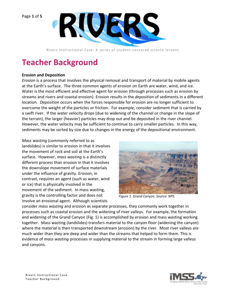
Page 1 of 5 Ri v er s In stru ct ion a l Ca s e: A s er i e s o f stu d en t - c en t er ed s ci en c e l e s son s Teacher Background Erosion and Deposition Erosion is a process that involves the physical removal and transport of material by mobile agents at the Earth’s surface. The three common agents of erosion on Earth are water, wind, and ice. Water is the most efficient and effective agent for erosion (through processes such as erosion by streams and rivers and coastal erosion). Erosion results in the deposition of sediments in a different location. Deposition occurs when the forces responsible for erosion are no longer sufficient to overcome the weight of the particles or friction. For example, consider sediment that is carried by a swift river. If the water velocity drops (due to widening of the channel or change in the slope of the terrain), the larger (heavier) particles may drop out and be deposited in the river channel. However, the water velocity may be sufficient to continue to carry smaller particles. In this way, sediments may be sorted by size due to changes in the energy of the depositional environment. Mass wasting (commonly referred to as landslides) is similar to erosion in that it involves the movement of rock and soil at the Earth’s surface. However, mass wasting is a distinctly different process than erosion in that it involves the downslope movement of surface materials under the influence of gravity. Erosion, in contrast, requires an agent (such as water, wind or ice) that is physically involved in the movement of the sediment. In mass wasting, gravity is the controlling factor and does not Figure 1. Grand Canyon. Source: NPS. involve an erosional agent. Although scientists consider mass wasting and erosion as separate processes, they commonly work together in processes such as coastal erosion and the widening of river valleys. For example, the formation and widening of the Grand Canyon (Fig. 1) is accomplished by erosion and mass wasting working together. Mass wasting (landslides) transfers material to the canyon floor (widening the canyon) where the material is then transported downstream (erosion) by the river. Most river valleys are much wider than they are deep and wider than the streams that helped to form them. This is evidence of mass wasting processes in supplying material to the stream in forming large valleys and canyons. Page 2 of 5 Weathering is the physical breakdown and chemical alteration of rocks and minerals at or near the Earth's surface due to interactions with living organisms, water and the atmosphere. Weathering is distinctly different from erosion in that weathering occurs in place and does not involve the movement or transport of sediment. The weathering of rocks results in two types of products: 1. solid particles (sand grains, clay minerals, etc.) 2. dissolved constituents in water The products of weathering (sediment) provide the materials that are involved in erosion and deposition. The weathering of rocks commonly results in the production different sizes of sediments being produced ranging from microscopic (clays) to sand- and gravel-sized particles. There are 3 types of sediment carried by a river: 1. dissolved load - transport of ions and chemicals in solution – partially responsible for the saltiness of the sea. 2. suspended load - typically the largest load and is composed clays, silt and fine sand. This material settles out when the river slows usually in an ocean or lake. 3. bed load - the material that is transported along the river bed by rolling, sliding and saltation (where the particles bounce or skip along the river bed). The sediment that is carried by a river is determined by the landscape that it flows through. Most of the sediment load of rivers is suspended load. As an example, the sediment load of the Mississippi River is composed of 26% dissolved load, 67% suspended load and 7% bed load. During erosion and deposition of sediment, the sizes of the particles can provide useful information about the environment of deposition. Low energy environments tend to involve smaller sedimentary particles whereas high energy environments commonly deposit larger sediments (such as gravel and boulders). Gravel deposits are found in high energy environments such as mountain streams and some beaches. Sands are found in intermediate energy environments such as beaches and river deposits. Clays are found in quiet environments such as lakes and the deep ocean. Because of changes in environmental energy (such as water velocity), different sizes of sediments may deposit and occur in association with one another. For example, the satellite image of the Mississippi River delta (Fig. 2) shows the transport and deposition of sediments where the river empties into the Gulf of Mexico. Since near shore environments have higher energy (due to currents and waves), only coarser sediments (such as sand) are deposited along the shore and in shallow water. However, fine sediments are suspended in the water column and are deposited in quieter offshore environments such as in the deeper ocean. Figure 2. Satellite image of the Mississippi River delta. Source: NASA. Page 3 of 5 Thus, different sedimentary environments occur over a broad area at the same time and sediments may be sorted by size. The term facies is used to describe sets of sedimentary rocks that grade into one another due to this sort of sorting of sediments by size. Figure 3. Graded sedimentary beds. In a depositional environment (such as a river), the environmental energy may experience large changes over time. Graded bedding of sediments is characterized by a change in grain size with coarser sediments at the base that grade upward into progressively finer ones. Graded beds (Fig. 3) represent depositional environments that decrease in energy as time passes. Graded bedding is common in stream deposits (commonly associated with storm surges) and other depositional environments such as turbidites (submarine landslide deposits). Rivers A stream is a general term for any channelized body of running water. Streams may range is size but there is no established nomenclature for naming a stream based upon its size. Although the term river is generally used for larger streams, other terms for small streams include creek, brook, or rill. Most water in streams is the result of surface runoff in the water (hydrologic) cycle. Other sources of stream water include ground water and the melting of glacial ice. The majority of streams empty into the ocean, a lake or another body of water. Some streams may terminate where they empty into a closed interior basin on land without an outlet (such as at the Great Salt Lake or Dead Sea). A river begins at a source (commonly in a mountainous region) and ends at its mouth (Fig. 4). The river is confined to flow in a channel that evolves (in size and shape) along the length of the river. The point where two rivers merge is called a confluence. A tributary Profile of a river from its source to mouth. is the term for a river that merges into a larger river. Page 4 of 5 The velocity of water flowing through the channel is a function of the size (cross-section) of the channel and the steepness of the terrain. In mountainous regions, the terrain is steeper and has a higher stream gradient (ratio of the drop in elevation per distance per distance the river flows). For example, a stream with a gradient of 1 m/km means that the elevation of the surface of the river decreases one meter for every kilometer that the river flows. In mountainous regions, a typical stream gradient may be greater than several meters per kilometer. Since water flows under the influence of gravity, water velocity in a region with a steep gradient is greater and can carry larger sediment particles. In regions that the landscape is relatively flat, the stream will have a small gradient and lower water velocity; its capacity to transport larger sedimentary particles is reduced. For example the gradient near the end of the Mississippi river is only ~7 cm/km. As indicated in Fig. 5, water in the middle of a stream channel has the highest velocity. The lowest flow velocity occurs along the stream bank and along the streambed due to friction. When there is a bend in the stream, the water with the highest velocity moves forward in a straight line where it encounters the bank on the outside of the Figure 5. Schematic diagram showing water bend; this results in a velocity in a stream channel when it encounters a zone along the bank bend. The longer the arrow, the higher the water of the stream that is velocity. prone to erosion. On the opposite bank, the water velocity is lowest. The lowest velocity is located on the inside bank where deposition of sediment occurs. Point bars are deposits that form on the inside curve of meanders, where the water velocity is lowest. Over time, point bars accumulate on the inside and erosion occurs on the outside of river bends, causing the channel to migrate and change shape. The concurrent erosion and deposition that occurs on opposite banks causes the stream channel becomes more curved in shape called a meander. As the channel of the river becomes more sinuous and curved, the ends of the meander may meet and cut off a portion of the channel forming an oxbow lake. Fig. 6 shows the development of a meander and how it may evolve to form an oxbow lake (bottom diagram). Figure 6. Schematic diagram showing the evolution of meanders and the formation of an oxbow lake. Source: Wikipedia User: maksim Rivers are short-lived features (in geologic time) and can change on timescales of 10’s to 100’s of years. Fig. 7 shows a satellite image of a mature river with many abandoned meanders and oxbow lakes as it has continued to evolve over time. Page 5 of 5 Figure 7. Satellite image showing the Rio Negro River (South America). The image shows the current river channel and many abandoned meanders and oxbow lakes as the river has evolved. Source: NASA. A typical stream has a profile where its source is located in a more mountainous region with steep gradients. As a stream flows away from its source, it generally moves into a region with low gradients (flat plains) and there is the development of extensive meanders. Streams near their source in a region with a high gradient are commonly referred to as “young” or “immature.” Streams in regions with low gradients and extensive meanders are called "old" or "mature." Mature and immature streams evolve differently. Immature streams with a steep gradient put most of their erosion into downward cutting making the river valley deeper with time and the channels that do not shift much laterally. In mature stream systems, there is less down-cutting of the river channel because of the low gradient. Thus, mature streams put more of their erosive action into side to side erosion leading to the development of meanders. Deltas and Alluvial Fans At its mouth, a river will drop its sediment due to a decrease in the velocity of the water. Alluvial fans and deltas form from the deposition of the sediment carried by the river. They are similar structures and differ mainly by being deposited either above or below water. Deltas form by the deposition of sediment below water when the mouth of a river enters an ocean or a lake. Delta formation is a continuous process as long as the river if flowing to its outlet. Alluvial fans form in arid regions in a terrestrial setting from the deposition of the sediment carried by the river as the flow enters a canyon or flatter plain. The formation of alluvial fans is commonly and episodic process where major deposition of sediments may occur during storms. Generally, rivers merge together where tributaries join with a river. It is common in deltas and alluvial fans for a stream to branch off into multiple smaller channels known as distributary channels that flow away from the main channel. Distributary channels can be seen in Figs. 8 and 9. Figure 8. Satellite image of the Mississippi River delta. Source: NASA Figure 9. Aerial photograph of the Hanaupah alluvial fan in Death Valley. Source: USGS


