Map Skills - Norwich School
advertisement
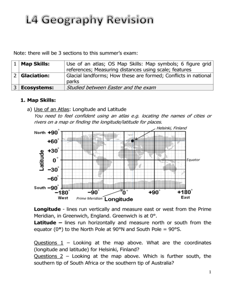
Note: there will be 3 sections to this summer’s exam: 1 Map Skills: 2 Glaciation: 3 Ecosystems: Use of an atlas; OS Map Skills: Map symbols; 6 figure grid references; Measuring distances using scale; features Glacial landforms; How these are formed; Conflicts in national parks Studied between Easter and the exam 1. Map Skills: a) Use of an Atlas: Longitude and Latitude You need to feel confident using an atlas e.g. locating the names of cities or rivers on a map or finding the longitude/latitude for places. Helsinki, Finland Prime Meridian Equator Prime Meridian Longitude - lines run vertically and measure east or west from the Prime Meridian, in Greenwich, England. Greenwich is at 0°. Latitude – lines run horizontally and measure north or south from the equator (0°) to the North Pole at 90°N and South Pole = 90°S. Questions 1 – Looking at the map above. What are the coordinates (longitude and latitude) for Helsinki, Finland? Questions 2 – Looking at the map above. Which is further south, the southern tip of South Africa or the southern tip of Australia? 1 b) OS Maps: symbols; points on a compass; 6-fig grid references; measuring distances – straight line and along a winding route; geographical features You need to feel comfortable using an OS Map. For example, knowing the basic map symbols (or where to look at the ‘key’ to find out) and then locating these symbols on OS Maps using 4 and 6 figure grid references. It is vital that you can give directions from one point to another using either points on a compass or distance instructions along a straight/winding route. Symbols: A few basic symbols but refer to your exercise book for the hand out I gave you and see if you can learn them… Bus station Train station Main Road Deciduous forest Coniferous forest Marsh + Viewpoint Camp site Place of worship PO Place of worship Place of worship Post w/ spire w/ tower Office Points on a compass: Think of a way to remember compass points. Never Eat Shredded Wheat? 2 4 and 6-fig grid references: Along the corridor and up the stairs…4 figure grid references are a helpful way of taking you to any square on a map. 6 figure take you to a precise point within a square. Remember to divide the square into 10 equal parts to find the final number… Tip! Try practising your OS Map skills using the following website: http://mapzone.ordnancesurvey.co.uk/mapzone/PagesHomeworkHelp/index.htm Measuring distances – straight line and along a winding route: The scale of a map shows how much you would have to enlarge your map to get the actual size of the piece of land you are looking at. For example, your map has a scale of 1:25 000, which means that every 1 cm on the map represents 25 000 of those same units of measurement on the ground (for example, 25 000 cm = 250 metres). That might sound a bit confusing, but OS maps have been designed to make understanding scale easy. A 1:25 000 scale map will often write the scale as: 4 cm to 1 km This means that every 4 cm on a map = 1 km in real life. To make it even easier, the grid lines are exactly 4 cm apart, so every square is 1 km by 1 km. Maps are made at different scales for different purposes. A 1:25 000 scale map is useful for walking, but if you use it in a car you will quickly drive off the edge! A 1:250 000 scale shows more land but less detail. 3 Straight line distances can be measured using a ruler to measure between Point A and Point B. You then use your scale to convert from cm to km. Winding routes are more fun but a bit trickier. Follow the steps below: i. Take a sheet of paper and place the corner of the straight edge on your starting point (mark this Point A) ii. Now pivot the paper until the edge follows your chosen route. iii. Every time the route disappears or moves away from the straight iv. v. edge of your paper, make a small pencil mark on the edge (notch) and pivot the paper do the edge is back on course. Continue in this manner until the measurement is completed. With a ruler measure your distance from Point A to end of your route and convert from cm to km. Question 3: Have a try with the route below (Scale - 4cm : 1km) Geographical features You need to know how to read the shape of the land using contours and also identify settlements (towns/villages on the map). On 1:25 000 scale maps height is shown using brown contours which join points of equal height above sea level. They are usually at intervals of 5 metres but can be 10 metres in mountainous regions. Remember: a) contour numbering reads up hill – in other words the top of the number is uphill and the bottom is downhill b) the closer contour lines are together, the steeper the slope. 4 Questions 4 – What are the 4 figure grid references for A, B and C? Questions 5 – What are the 6 figure grid references for A, B and C? Answers: Q1 - 60˚N (Latitude) and 25˚E (Longitude) Q2 – Australia Q3 – 2km (as 8cm) Q4 – A= 8326; B = 8424; C = 8523 Q5 - A= 616336; B = 636325; C = 633342 2. Glaciation: a. Label features on a glaciated landscape Know what the main features are and how to identify them 5 b. Types of weathering and erosion There are 3 main processes at work in glaciated landscapes: Weathering: Erosion: Deposition: What is it? What is it? What is it? material broken down broken material ALSO carried material being on site – e.g. Freeze- away by a moving force – e.g. carried is dropped thaw plucking and abrasion e.g. moraine e.g. Freeze-thaw: e.g. Plucking -Water runs into small cracks during the day. -At night the water freezes and expands outward enlarging the crack. The next day the ice melts and contracts more water runs into the crack. -Freeze-thaw process is repeated enlarging the crack each time. -Eventually parts of the rock can break off in jagged pieces -As glacier moves down a valley, it puts pressure on the valley base creating friction and heat which causes ice nearby to melt. -Water runs into rock cracks/ joints and freezes due to the cold. -When the glacier moves it then pulls some of the rock face with it e.g. moraine Debris transported and deposited by glaciers. Formed by erosion of side and base of valley (e.g. plucking) or weathering from above (e.g. freezethaw) -Types? Lateral, Medial & Terminal e.g. Abrasion -Rock frozen to the base and the back of the glacier scrapes and e.g. drumlin scours the bed rock. In lowland areas, drumlins form when sediment is deposited by the glacier when it becomes too heavy often when melting Stoss end Lee end e.g. erratic Large boulders carried long distances by glaciers before being deposited 6 a. Corrie formation and description: Formation? i. ii. iii. iv. v. Snow collects in a natural hollow on the side of a mountain. Over time, further snow collects in the hollow. This extra weight compresses the snow beneath turning it into ice. The hollow is deepened and widened by the corrie glacier through the processes of abrasion and plucking This deepening leads to an ‘armchair’ shape characteristic of a corrie and causes a ‘rock lip’ to be formed. When the ice melts, a lake is left in the corrie. This is called a tarn. Description? Steep back wall Moraine deposited on front lip Armchair shaped hollow b. Formation of arêtes and pyramidal peaks: Arête: Formed when 2 corries form back to back. They have steep and rocky sides and form a sharp ridge between corries Pyramidal Peak: When corries form on 3 or more sides. Top of mountain is a sharp peak of jagged rock. 7 c. Formation of U-shaped valleys and ribbon lakes U-Shaped valley formation: BEFORE: V-Shaped valley with rivers winding their past hard and soft rocks to form interlocking spurs. DURING: Glacier fills the valley and moves downhill under gravity. Its power erodes any rock in its path. Interlocking spurs are therefore cut back to form truncated spurs. AFTER: U-Shaped valleys with steep walls of bare rock and flat bottoms straighter than v-shaped valleys before. Ribbon Lakes: a) Glacier moves down a valley passing over bands of hard and soft rock b) The glacier erodes the valley bed via abrasion and plucking. Softer rocks are eroded more quickly to a greater depth forming a hollow. At the end of the glacier moraine is deposited which blocks the valley. c) After glacial melt the hollow fills with water – a ribbon lake. d. Use of glaciated landscapes and possible conflicts: You need to know how areas with glaciers or post-glaciation are used by humans e.g. via skiing in the Alps or sailing on Lake Windermere in the Lake District. Key people include: tourists, local residents, businesses and environmental stewards e.g. National Park Wardens You need to understand that different users of these spaces have different objectives e.g. a walker may want to enjoy the beautiful scenery in quiet whilst a jet-ski owner may want to enjoy speed and noise on the lake. They therefore need to find compromises. Revision Tip: Use the glaciated landscape diagram in your books and test your ability to find the key features. Then take them in turn and see if you can explain how they formed with the use of geographical terms such as erosion, weathering and deposition. Good luck! 8
