Earthbyte group
advertisement
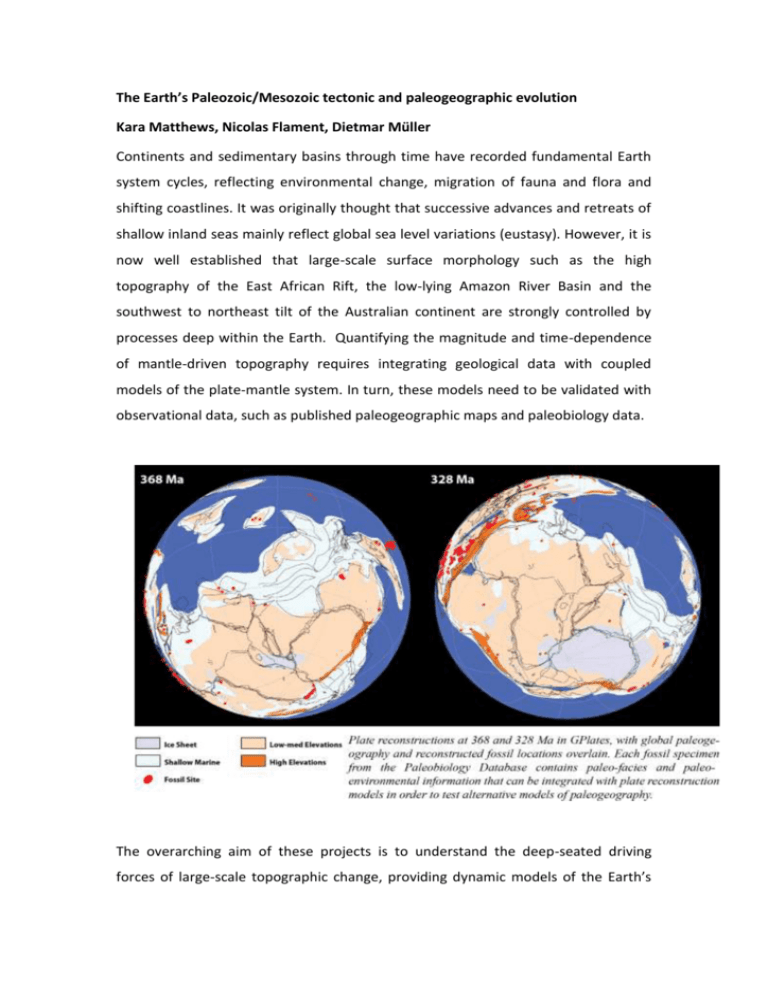
The Earth’s Paleozoic/Mesozoic tectonic and paleogeographic evolution Kara Matthews, Nicolas Flament, Dietmar Müller Continents and sedimentary basins through time have recorded fundamental Earth system cycles, reflecting environmental change, migration of fauna and flora and shifting coastlines. It was originally thought that successive advances and retreats of shallow inland seas mainly reflect global sea level variations (eustasy). However, it is now well established that large-scale surface morphology such as the high topography of the East African Rift, the low-lying Amazon River Basin and the southwest to northeast tilt of the Australian continent are strongly controlled by processes deep within the Earth. Quantifying the magnitude and time-dependence of mantle-driven topography requires integrating geological data with coupled models of the plate-mantle system. In turn, these models need to be validated with observational data, such as published paleogeographic maps and paleobiology data. The overarching aim of these projects is to understand the deep-seated driving forces of large-scale topographic change, providing dynamic models of the Earth’s subduction history, deep plume sources and dynamic topography for the PaleozoicMesozoic periods. The Paleozoic follows the breakup of the supercontinent Rodinia after the end of the so-called Snowball Earth period. Throughout the early Paleozoic, the Earth's landmass was broken up into a substantial number of continents. Towards the end of the era, continents gathered together into the supercontinent Pangaea. We offer two Honours projects focussed on building models for the Paleozoic/Mesozoic Earth using the software GPlates, and using geological observations to test geodynamic models, which predict mantle convection patterns and surface uplift/subsidence through time: Project 1: The evolution of proto-Atlantic/Indian ocean basins and marginal seas in the Cambrian to Devonian Project 2: The evolution of proto-Atlantic/Indian ocean basins and marginal seas in the Carboniferous to Jurassic These projects will address the following questions: How were ocean basins, including back-arc basins, created and destroyed between the Cambrian and Jurassic periods? How have the fundamentally different plate tectonic configurations before and during/after the assembly of the supercontinent Pangea affected subduction history, the history of mid-ocean ridge system evolution, mantle convection patterns and ultimately regional sea level fluctuations? The projects will involve acquiring various software and database skills, including GPlates, including spatio-temporal data mining, ArcGIS, the Generic Mapping Tools, shell scripting, dealing with the paleobiology database, as well as learning the basics of geodynamic modelling. These projects will prepare students both for working in the exploration industry as well as for a research-oriented career in government agencies or universities. Constructing a revised plate tectonic history for the Caribbean Supervisors: Prof Dietmar Müller, Dr Simon Williams The Caribbean has witnessed a complex geological evolution during the last 150 Ma. Understanding this history, in particular tracking the locations and polarity of subduction zones within this region, has important implications for geodynamic modeling of the area. However, there remains much debate amongst geoscience researchers over some of the fundamental details of this area’s plate tectonic history – for example the polarity of subduction along the so-called ‘Great Arc’ of the Antilles during the Cretaceous, and whether or not a large Oceanic Plateau collided with this arc. The model of Ross and Scotese (1988) provides a quantitative framework of how the different plates and magmatic arc fragments evolved within this region. However, a wealth of new geological and geophysical data have been collected during this time, and there is a clear need to reassess these earlier models in the context of these new data. Numerous authors propose alternative reconstruction histories in terms of simple cartoons for small regions of study. In our case you will use GPlates (plate tectonic analysis software developed by the Earthbyte group) to test and generate truly quantitative models that fit within a globally consistent plate model. The central aim of this project will be to derive revised plate reconstructions for the Caribbean. The project will be multidisciplinary in nature – collating data from online sources and the scientific literature that tell us about the nature and timing of geodynamic processes occurring throughout the Caribbean – for example magmatism, subduction, phases of extensional and compressional deformation. You will then assimilate all these data within GPlates, and use these constraints to test existing models of Caribbean geodynamics and generate a new set of plate reconstructions including plate boundary locations and plate velocities. This project will also involve the analysis of seismic tomography and geodynamic modeling output to help validate the chosen locations of subduction. Tilting continents: influence of dynamic topography on relative sea level Supervisors: Nicolas Flament, Dietmar Müller It has long been identified that continents tilt as they drift over the convecting mantle. Recent work has shown that mantle convection makes it impossible to determine global sea level at a single passive margin. The aim of this project is to estimate the relative contributions of mantle convection and global sea level change to the waxing and waning of continental interiors by shallow seas observed in the geological record. Continental dynamic topography at 101 Ma (left), and its rate of change (right) between 111 and 101 Ma, both shown in the present-day frame of reference The project will involve analysing the dynamic topography and its rate of change predicted by global mantle flow models (example shown on figure) and comparing them to geological constraints. This will require the use of analytical skills, basic scripting (in shell, python or other) and the use of various software skills, including GPLates, the Generic Mapping Tools. Part of a large industry collaboration, this project will prepare students both for working in the exploration industry as well as for a research-oriented career in government agencies or universities. Tectonic evolution of the eastern Tethys Supervisors: Dr Simon Williams, Dr Kara Matthews The continental margins of the Tethys Ocean have undergone a largely uninterrupted history of sedimentation and carbonate platform build-up over the last 500 Myr, accentuated by episodes of rift basin formation, broad subsidence and major transgressions in the mid-late Cretaceous. While the contribution of mantle flow to the flooding of other continents (e.g. Cretaceous North America) has long been established, it is still unknown to what extent flooding in Eurasia at this time, or any other time, is due to dynamic topography. Part of the problem is a lack of detailed plate reconstructions within a deforming plate framework for the area to use as surface boundary conditions into numerical models. In this project, you will construct an end-member plate kinematic model for the opening and closure of the Eastern Tethys Ocean, which will include a detailed history of microcontinent accretion and back-arc basin formation along the southern Eurasian margin and rifting and basin formation along the western Australian margin. These reconstructions will be examined in the context of paleo-geographic maps and compared to geodynamic model output to better resolve the continental flooding history along the northern Tethyan margin. 3D Numerical Experiments of Salt Tectonics Supervisors: A/Prof Patrice Rey, Luke Mondy and Dr Sascha Brune Evaporite deposits exert a very strong control on the structural evolution of rift basins. Because of its capacity to flow at upper crustal temperatures and under small deviatoric stresses, salt allows for the mechanical decoupling of the post-salt sedimentary sequences, which can slide above pre-salt strata. These gravitational décollements produce significant extensional and contractional structures, as well as salt diapirs and salt canopies often closely related to hydrocarbon traps. Through a series of 3D numerical experiments, the project aims to understand how the thickness, depth and viscosity of the salt layers control the style, distribution and magnitude of deformation. This project doesn’t require any particular computational skills and can suit an astute student interested to develop computational skills. Landscape connectivity through the Wilson cycle: Implication for biodiversity Supervisors: A/Prof Patrice Rey, Guillaume Duclaux and Luke Mondy We know that plate tectonics, through continental break-up, is a major driver for the evolution of species. At the scale of each continent, landscape connectivity favour natural selection processes, which impediment to biodiversity. In the contrary, during orogenic periods, the fragmentation of landscape favour the multiplication of ecological niche driving species differentiation and favouring biodiversity. This pioneering project aims at investigating how tectonic processes coupled to surface processes interplay to control landscape connectivity. The project will involve studying how a fragmented landscape, made of multiple drainage basins, high mountain ranges, elevated plateaux and deep valley, evolves under the action of erosion, sediments transport and accumulation. If time permit, the project will also investigate the evolution of a highly connected landscape during orogenesis. What Happens to the Continental Crust Once it Has Been Subducted? Supervisors: Patrice Rey, Christian Teyssier (Univ. of Minneapolis) and Donna Whitney (Univ. of Minneapolis) Continental subduction is the process through which the continental crust gets dragged into a subduction zone burying the continental crust deep into the diamond stability field (>150km). The subduction of the continental crust is however limited by the buoyancy of the crust. It is not clear what happens to the continental crust once the maximum depth is reached. Does the crustal slab melt and rise through the overriding mantle wedge as a large crustal diaper that flattens out at the base of the overriding crust, or does the slab get exhumed back to the surface as a rigid buoyant slab? Also important is the question of how the growing gravitational force related to the subducting continental crust impacts on the converging continents. This project aims at exploring the processes controlling the relaxation of subducted continental crusts. The project involves 2D and 3D thermo-mechanical experiments using Underworld. The subduction of Baltica under Laurentia (440-390 Ma) will be used as a prime example providing first order constraints on the timing of continental subduction as well as the PTt paths followed by exhumed high-pressure crustal eclogites. The role of gravitational forces in the opening of back-arc basins: application of the opening of the Aegean Sea Supervisors: Patrice Rey Slab rollback, the oceanward motion of the subducting oceanic lithosphere, is a favourite amongst the processes leading to back-arc extension and detachment of micro-continents from continental mainlands. A different way to interpret the dynamic of back-arc extension involves gravitational forces that arise from the thinning of the lithospheric mantle. A recent set of numerical experiments show that gravitational forces can drive back-arc extension forcing slab rollback. Coeval extensional and contractional tectonics in the overriding plate is a key observable that can help to decipher between rollback-driven back-arc extension and back-arc driven slab rollback. This project aims at exploring further the link between gravitational forces and backarc extension and to apply this new concept to the opening of the Tasman Sea, the Aegean Sea and the evolution of the Appennines. How far can the lower crust flow? Supervisor: Patrice Rey Gravitational potential energy stored in an orogenic plateau can be strong enough to deform the surrounding region (foreland), hence contributing to both plateau growth and collapse. Gravity-driven channel flow from the plateau lower crust into the foreland lower crust, called channel extrusion, has been proposed as a main contributor to the eastward growth of the Tibetan plateau, possibly driving the lower crustal channel as far as 2000 km in 15 myr, at an average flow velocity over 10 cm/yr. However, isostasy-driven upward flow in response to either erosion focused on the plateau steep margins, or stretching of the plateau upper crust to produce domical structures (metamorphic core complexes), compete with horizontal channel flow extrusion. Using 2D and 3D thermal-mechanical modelling, this project aims at exploring the dynamic coupling among the various flow processes that take place during gravitational collapse and the assess the magnitude of channel extrusion in southeast Tibet. Multispectral Mapping the Opalized Redox Front in the Great Artesian Basin Supervisor: Patrice Rey, Gemma Roberts The vast majority of precious opal is hosted in the Great Artesian Basin (GAB) in central Australia, one of the largest intra-continental basins on Earth. Opal formed via acidic oxidative weathering following the regression of the Eromanga Sea that flooded central Australia between 125 and 95 Ma. This opalized horizon is now preserved below the Tertiary unconformity. Using multispectral satellite images this project aims i/ to construct at the scale of the Great Artesian Basin a 3D map of the unconformity between Tertiary sedimentary rocks and the Lower-Cretaceous formations, and ii/ to map where the opalized redox front has been preserved and where it has been eroded. This project will be appropriate for a student willing to become an expert in satellite image processing, and 3D surface modelling. Control of inherited fault patterns on rift evolution Supervisors: Sascha Brune and Patrice Rey The architecture of continental rift systems (e.g East Africa), and passive margins (e.g. Africa-South America, Australia-Antarctica) is controlled by plate kinematics, rock rheology, and volcanism. This research field is of special importance to the hydrocarbon industry, since rift basins are primary target for exploration. Here you have the opportunity to evaluate the impact of inherited fault networks on the evolution of rift systems and subsequent passive margin formation. Using an established geodynamic model setup, you will study the effect of random initial fault patterns on key rift properties: symmetry, basin depth, and margin width. This will require basic analytical skills and some computational competence for scripting and model visualization. Rate of deformation for two rift models with different random initial fault patterns but otherwise identical properties. This illustrates the impact of the initial fault configuration on overall rift dynamics. Sinking slabs: Deciphering the 200 My memory of Earth’s mantle Supervisors: Sascha Brune, Nicolas Flament, and Dietmar Müller At subduction zones, dense lithospheric slabs are pulled into the inside of the Earth where they sink for hundreds of millions of years towards the core mantle boundary. The present day structure of Earth’s mantle as it is imaged through seismic tomography contains information on the locations of ancient subduction zones and past plate motion. When deciphering this information, the movement of slabs within the convecting mantle of the Earth must be taken into account. However, fundamental physical properties of the deep Earth (e.g. the viscosity distribution) are not easily accessible. Within this project you will apply an established numerical model of mantle convection. The aim is to evaluate the vertical and lateral velocities of subducted slabs for different viscosity distributions of Earth’s mantle which will give new insight into the viscosity distribution of the deep Earth. By comparing the numerical results to seismic tomography images (see Figure below), you will establish a link between past plate motions and present-day mantle structure. This will be important in order to enhance absolute plate motion models before 100 My. You will be trained in using the plate tectonics software GPlates, the mantle convection model Terra, standard visualization tools (GMT and Paraview) and basic scripting. You will acquire valuable insight into geodynamic processes that are ultimately responsible for the formation of georesources. This knowledge base might make the difference when you apply for positions in exploration industry or if you start a research career at a university. Comparing predictions of different numerical model setups (red, blue, black contours) to present-day mantle structure from seismic tomography (in background).


