Clouds and Air Pressure Study Guide Name
advertisement
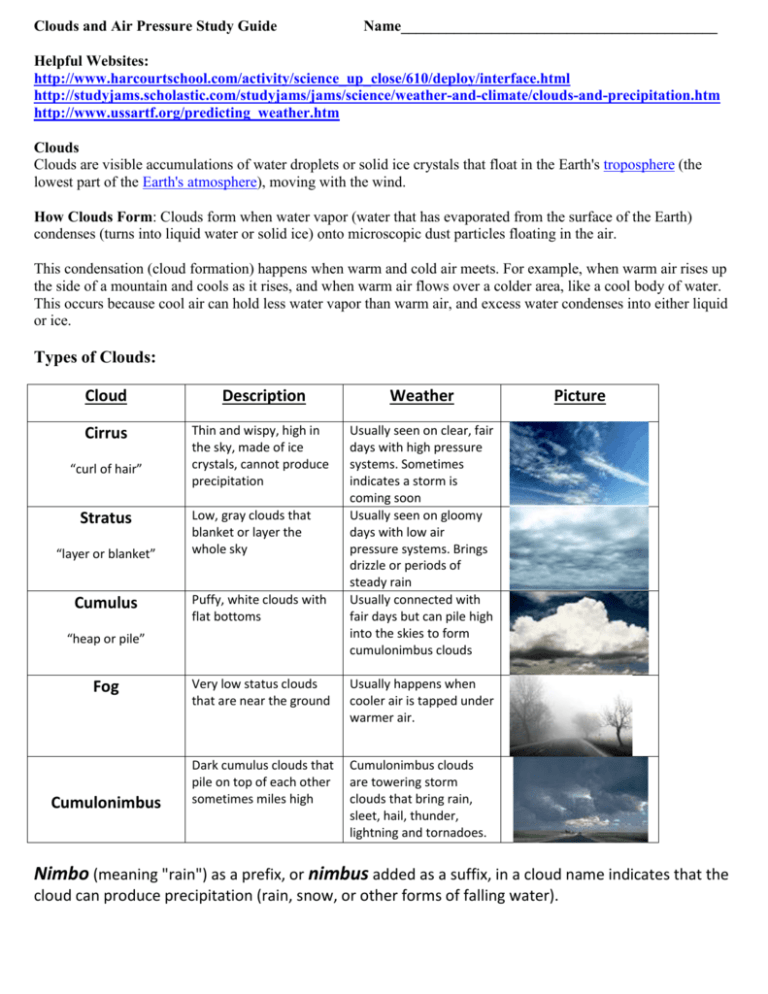
Clouds and Air Pressure Study Guide Name__________________________________________ Helpful Websites: http://www.harcourtschool.com/activity/science_up_close/610/deploy/interface.html http://studyjams.scholastic.com/studyjams/jams/science/weather-and-climate/clouds-and-precipitation.htm http://www.ussartf.org/predicting_weather.htm Clouds Clouds are visible accumulations of water droplets or solid ice crystals that float in the Earth's troposphere (the lowest part of the Earth's atmosphere), moving with the wind. How Clouds Form: Clouds form when water vapor (water that has evaporated from the surface of the Earth) condenses (turns into liquid water or solid ice) onto microscopic dust particles floating in the air. This condensation (cloud formation) happens when warm and cold air meets. For example, when warm air rises up the side of a mountain and cools as it rises, and when warm air flows over a colder area, like a cool body of water. This occurs because cool air can hold less water vapor than warm air, and excess water condenses into either liquid or ice. Types of Clouds: Cloud Description Weather Cirrus Thin and wispy, high in the sky, made of ice crystals, cannot produce precipitation Usually seen on clear, fair days with high pressure systems. Sometimes indicates a storm is coming soon Usually seen on gloomy days with low air pressure systems. Brings drizzle or periods of steady rain Usually connected with fair days but can pile high into the skies to form cumulonimbus clouds “curl of hair” Stratus “layer or blanket” Cumulus Low, gray clouds that blanket or layer the whole sky Puffy, white clouds with flat bottoms “heap or pile” Fog Cumulonimbus Very low status clouds that are near the ground Usually happens when cooler air is tapped under warmer air. Dark cumulus clouds that pile on top of each other sometimes miles high Cumulonimbus clouds are towering storm clouds that bring rain, sleet, hail, thunder, lightning and tornadoes. Picture Nimbo (meaning "rain") as a prefix, or nimbus added as a suffix, in a cloud name indicates that the cloud can produce precipitation (rain, snow, or other forms of falling water). High and Low Air Pressure Certain weather conditions are associated with high and low pressure systems. (This is due to the uneven heating of the Earth by the Sun.) Winds blow from high to low pressure. As the warm air rises, cooler air swoops down to take its place. Remember warm air rises and cool air sinks. High Pressure Areas (Cooler, Clear Days) High pressure areas, or highs, are shown by "H" symbols. In a high pressure system, air pressure is greater than the surrounding areas. This difference in air pressure results in wind, or moving air. In a high pressure area, air is more dense than in areas of lower pressure. The result is that air will move from the high pressure area to an area of less density, or lower pressure. Winds blow away from high pressure areas toward areas having lower air pressure. Low Pressure Areas (Warmer, Rainy Days) Low pressure areas, or lows, are shown by "L" symbols. Winds tend to blow into low pressure areas because air, like other gases, moves from areas of higher pressure into areas of lower pressure. As winds blow into a low, the air moves up. This upward flow of air can cause clouds and precipitation to form. Air pressure is measured by barometers. In general, weather will improve when pressure increases and worsen when pressure decreases. The larger the difference in air pressure the stronger the winds blow. A low reading on a barometer indicates warmer, rainy days. A high reading on a barometer indicates cooler, fair days. What is air pressure? • • • • It is caused by the weight of all the air in the atmosphere pressing down on Earth. It is also known as atmospheric pressure. Air pressure changes with the height and also when air warms up or cools down. Changes in air pressure cause changes in the weather. Cloud Types One factor that influences weather is moisture in the air. Water vapor in the atmosphere can condense into clouds. When there is enough moisture in the clouds, the water can then fall to the ground as rain, hail, snow, or sleet. There are several different types of clouds, and each is present in a different kind of weather. Cumulus Cumulus clouds are tall and puffy. They can be many different shapes and look a lot like cotton balls. When sunlight hits these clouds, they are bright white. Cumulus clouds usually mean fair weather. Stratus Stratus clouds are often grey and block out much of the Sun. They grow across the sky in layers. Stratus clouds often carry precipitation. However, it is usually light rain or drizzle. Most stratus clouds are found lower in the atmosphere, but there are some other types of stratus clouds found at higher altitudes. Cirrus In cirrus clouds, water droplets collect to form thin curves with no clear shape. Cirrus clouds are found high in the sky (at about 18,000 feet or above). Cirrus clouds tend to form when the wind is strong. Cumulonimbus Cumulonimbus clouds can't hold all their water droplets. These drops can become so heavy that they fall as rain, snow, or hail. These clouds look tall, puffy, and gray. They are often called storm clouds, and they may bring thunder and lightning.
