asera - Severn Estuary Gateway
advertisement
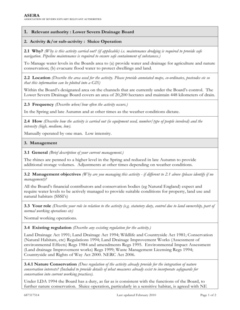
ASERA ASSOCIATION OF SEVERN ESTUARY RELEVANT AUTHORITIES 1. Relevant authority : Lower Severn Drainage Board 2. Activity &/or sub-activity : Sluice Operation 2.1 Why? (Why is this activity carried out? (if applicable) i.e. maintenance dredging is required to provide safe navigation. Pipeline maintenance is required to ensure safe containment of substances.) To Manage water levels in the Boards area to (a) provide water and drainage for agriculture and nature conservation; (b) evacuate flood water to protect dwellings and land. 2.2 Location (Describe the area used for the activity. Please provide annotated maps, co-ordinates, postcodes etc so that this information can be plotted into a GIS) Within the Board’s designated area on the channels that are currently under the Board’s control. The Lower Severn Drainage Board covers an area of 20,200 hectares and maintain 448 kilometers of drain. 2.3 Frequency (Describe when/how often the activity occurs.) In the Spring and late Autumn and at other times as the weather conditions dictate. 2.4 How (Describe how the activity is carried out (ie equipment used, number/type of people involved) and the intensity (high, medium, low). Manually operated by one man. Low intensity. 3. Management 3.1 General (Brief description of your current management.) The rhines are penned to a higher level in the Spring and reduced in late Autumn to provide additional storage volumes. Adjustments at other times depending on weather conditions. 3.2 Management objectives (Why are you managing this activity - if different to 2.1 above (please identify if no management)? All the Board’s financial contributors and conservation bodies (eg Natural England) expect and require water levels to be actively managed to provide suitable conditions for property, land use and natural habitats (SSSI’s) 3.3 Your role (Describe your role in relation to the activity (e.g. statutory duty, control due to land ownership, part of normal working operations etc) Normal working operations. 3.4 Existing regulation (Describe any existing regulation for the activity.) Land Drainage Act 1991; Land Drainage Act 1994; Wildlife and Countryside Act 1981; Conservation (Natural Habitats, etc) Regulations 1994; Land Drainage Improvement Works (Assessment of environmental Effects) Regs 1984 and amendments Regs 1995. Environmental Impact Assessment (Land drainage Improvement works) Regs 1999; Waste Management Licensing Regs 1994; Countryside and Rights of Way Act 2000. NERC Act 2006. 3.4.1 Nature Conservation (Does regulation of the activity already provide for the integration of nature conservation interests? (Included to provide details of what measures already exist to incorporate safeguards for conservation into current working practices). Under LDA 1994 the Board has a duty, as far as is consistent with the functions of the Board, to further nature conservation. Sluice operation, particularly in a sensitive habitat, is agreed with NE 687317514 Last updated February 2010 Page 1 of 2 ASERA ASSOCIATION OF SEVERN ESTUARY RELEVANT AUTHORITIES under the Boards water level management plan. 3.5 Other management 3.5.1 Is your organisation developing any plans/initiatives/codes of conduct in relation to the activity? (please give details & web site reference if available). The Board already have a water level management plan agreed at Slimbridge and are currently in the process of agreeing to a water level management plan at Walmore Common, Nr Westbury on Severn. 3.5.2 Are you aware of any other plans/initiatives in relation to the management of the activity (please give web site reference if available) Nature conservation and the management of drainage channels. (Produced jointly by EN and ADA) 3.5.3 Outline any other known management of the activity (e.g. recreational clubs, voluntary groups). Slimbridge Wildfowl and Wetlands Trust. 4. Current information 4.1 Monitoring/research (Are you undertaking any current monitoring/research of the activity?) Monitoring Of water levels is a continuous activity 4.2 Why is it carried out? To ensure the Board give the best service to rate payers so that agricultural land can be productive but also to provide and enhance where practicable the nature conservation interests. 4.3 Please list any research/monitoring reports and their format (e.g. paper, GIS, please give web site reference if available) Verbal reports are minuted at Board meetings. 4.4 Are you aware of anyone else who carries out monitoring/research of the activity? No 687317514 Last updated February 2010 Page 2 of 2
