GEO TEST
advertisement
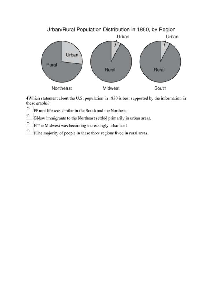
4Which statement about the U.S. population in 1850 is best supported by the information in these graphs? FRural life was similar in the South and the Northeast. GNew immigrants to the Northeast settled primarily in urban areas. HThe Midwest was becoming increasingly urbanized. JThe majority of people in these three regions lived in rural areas. 15The two photographs show how the environment — A can be changed by natural forces B recovers from pollution over time C can be altered to suit human habitation D can be protected by humans 32The trade pattern shown on this map, known as the triangular trade, involved the direct exchange of — F fish for lumber G sugar for ivory H guns for rice J rum for slaves 1According to the map above, which of these statements is true? A Turkmenistan is between Uzbekistan and Iran. B Uzbekistan has the longest border with Afghanistan. C The border between Iran and Afghanistan runs east to west. D Kabul is closest to Afghanistan’s border with Uzbekistan. 3Which conclusion is best supported by the graph above? AIn 1960, more immigrants had been born in Asia than in Europe. BFrom 1960 to 1990, promotional campaigns increased the overall number of European immigrants. CIn 1990, more immigrants had been born in Latin America than in Asia. DFrom 1960 to 1990, immigration restrictions reduced the overall number of Asian immigrants. 6According to the information in the graph, in 2000 — Flabor costs in Thailand were subsidized by the government Gunemployment was higher in Peru than in Sweden Hlabor costs were lower in Italy than in Sweden Jlabor costs were higher in Italy than in Australia 8According to the map above, which of these countries does not include land within the Arctic Circle? F Greenland G Norway H United Kingdom J United States 8The map above shows the spread of which type of music through cultural diffusion? F Opera G Bluegrass H Classical J Jazz 17Which conclusion about the spread of the bubonic plague to southern Europe can best be drawn from the map above? AThe spread of the disease followed the routes of old Roman roads. BThe disease was carried by ship to port cities. CThe spread of the disease was limited by cold climates. DThe disease affected only European cities. 19According to the map above, the most densely populated areas of Madagascar are — Aon the island’s northern tip Blocated along the western coast Clocated mainly in the central region Dfound primarily in the south 20Which of these is an example of a biased statement? FTexas is the second-largest state in the United States. GTexas is the most important state in the United States. HTexas contains three of the ten largest cities in the United States. JTexas borders four other states in the United States. 5Which statement is supported by the information in the map above? ATamales have become a popular food in the Mississippi Delta region. BTamales are inexpensive in coastal Mississippi. CTamales made in Mississippi are different from those made in Texas. DTamale production in the Mississippi Delta region is supported by government subsidies. 86. Which of the following has allowed soccer fans in different countries to watch the World Cup finals live? FData storage and retrieval systems GLightweight construction materials HSatellite communications and broadcasting networks JBetter semiconductors 31According to the map above, which statement most accurately describes the distribution of cities shown above? AThe population density is greatest along China’s inland borders. BUrban development is more heavily concentrated in eastern China. CRice farming is most successful in the mountains of southwestern China. DExtreme temperatures in northeastern China make the region unsuitable for human habitation. 34According to the map above, which of these statements is true? FThe Chisholm Trail and the Western Trail split just north of Fort Worth. GFort Griffin was the last stop along the Western Trail. HSan Antonio was an important town on the Brazos River. JRed Bluff Crossing and Doan’s Crossing were located where cattle trails crossed the Red River. 37The box above lists important influences on the — Adecline in international conflicts Binteractions within a global community Creduction of global poverty Dcreation of an international government 38Based on the map above, which geographic factor best determined the location of Greek colonies? FAccessibility of water for communication and trade GProximity to valuable mineral deposits HAvailability of land in fertile river valleys JCloseness to parent cities for support and military aid 41Based on the table above, which country appears to have the best health care? AArgentina BBolivia CChile DVenezuela 46The completion of the Channel Tunnel most likely resulted in — Fdecreased tourism in the United Kingdom and France Ggreater ease of travel between the United Kingdom and France Ha decline in automobile sales in the United Kingdom Jan increase in air pollution in France 48Which of the following statements is supported by the information above? FNorth America has not developed a manufacturing capability. GLatin America and North America produce similar percentages of mining exports. HAsia has not developed agricultural products suitable for export. JLatin America and Africa export the majority of the world’s manufactured goods. 49The map above indicates that — Atrade along the Silk Road was dominated by Italian and Greek merchants Bthe Silk Road was constructed by the governments of the countries it connected Ctrade along the Silk Road involved covering long distances and mountainous terrain Dthe Silk Road included ports on the Arabian Sea and the Indian Ocean 50Which of the following statements is supported by the information in the graph above? FEnergy consumption in the Asia and Oceania region was lower than in any other region. GThe Americas as a region consumed more energy than any other region. HOn a regional level, Africa consumed more energy than Eurasia. JOn a regional level, the Middle East consumed more energy than Europe. 1The photograph above shows how farmers on the Great Plains — Autilized irrigation techniques Badapted to their environment Cdeveloped new agricultural technology Dmaintained contact with their neighbors 3Which technological advance from the nineteenth century resulted in all the effects listed above? ACotton gin BCanals CRailroads DTelephone 4The illustration above demonstrates one problem associated with — Fovercrowding in urban tenements Gthe growth of political machines Hthe overproduction of consumer goods Jlabor union activism in urban areas 19Which conclusion is supported by the information in the heat-island profile above? ARural activity is the dominant cause of global warming. BSuburban residential areas experience the greatest heat-island effect. CDense urban areas are a significant cause of regional warming. DCity parks increase the heat-island effect. 23Dr. Hector P. García founded the American GI Forum to ensure that Hispanic veterans received — Athe same honorary rank as other veterans who served Blifetime employment in the military Cjob placement in medical professions Dthe same benefits provided to other veterans 28Which event most contributed to the large number of trucks coming into the United States, as shown in the map above? FThe establishment of the North Atlantic Treaty Organization (NATO) GThe implementation of the North American Free Trade Agreement (NAFTA) HThe implementation of the Kyoto Protocol JThe signing of the World Trade Agreement 40The federal lands shown above were set aside as a response to concerns about — Fborder conflicts Gcommunity development Henvironmental conservation Jproperty values 41According to the 2000 map above, the most densely populated areas in the world are located between — A15°N and 45°N B0° and 15°S C45°N and 75°N D30°S and 45°S 46Which of the statements above most clearly demonstrates a negative bias? FStatement 1 GStatement 2 HStatement 3 JStatement 4 48Which statement about patterns of settlement in West Texas is supported by the map above? FThe junction of two highways is often the location of a town. GThe most populous areas are located along Highway 118. HMost towns are located on waterways. JBig Bend National Park is a highly urbanized area. 53According to the table above, which area experienced continued growth in its percentage of the world’s population from 1750 to 1999? AAfrica BAsia CLatin America and the Caribbean DNorthern America 55According to the map above, which two countries produced the most carbon dioxide gas emissions in 2000? AAustralia and Great Britain BRussia and Mexico CChina and the United States DIndia and Canada In which U.S. region did many pioneers live in houses like this one? AEast Coast BPacific Northwest CGreat Plains What was the main purpose of the Great Wall of China? FTo protect China from foreign invaders GTo unite Chinese territories HTo irrigate farms in China Based on the information in this table, which nation most likely has the lowest standard of living? ACanada BMexico CIndia Based on these diagrams, why might Model A represent a more convenient city in which to live? FModel A has larger houses. GModel A decreases the travel distance to work. HModel A has more parks. What is a result of the technology shown in this photograph? AMore money to build highways BLess need for steel CIncreased travel options According to this map, which economic activity used the most land in these Spanish colonies? FCattle raising GSugar production HCoffee production Which factor has historically contributed most to the economy of Baghdad? FIts location north of Saudi Arabia GIts location on the Tigris River HIts location west of Iran Which numbered area on the map made it more difficult to build the Transcontinental Railroad in the late 1860s? A1 B2 C3 The data in this table support which statement? FMarket economies have the highest infant mortality rates. GNations with higher literacy rates have the most people working in agriculture. HTraditional economies have the most people working in agriculture. According to this map, which U.S. region had the lowest population density in 2000? FSoutheast GNortheast HRocky Mountains Which was a lasting effect of the activities shown in this drawing? FNative Americans of the Great Plains lost a natural resource that was important to their culture. GSettlers in the West started ranches instead of farms. HNative Americans of the Great Plains lost their influence on eastern markets.
