Observed characteristics of the mean Sahel rainy season
advertisement
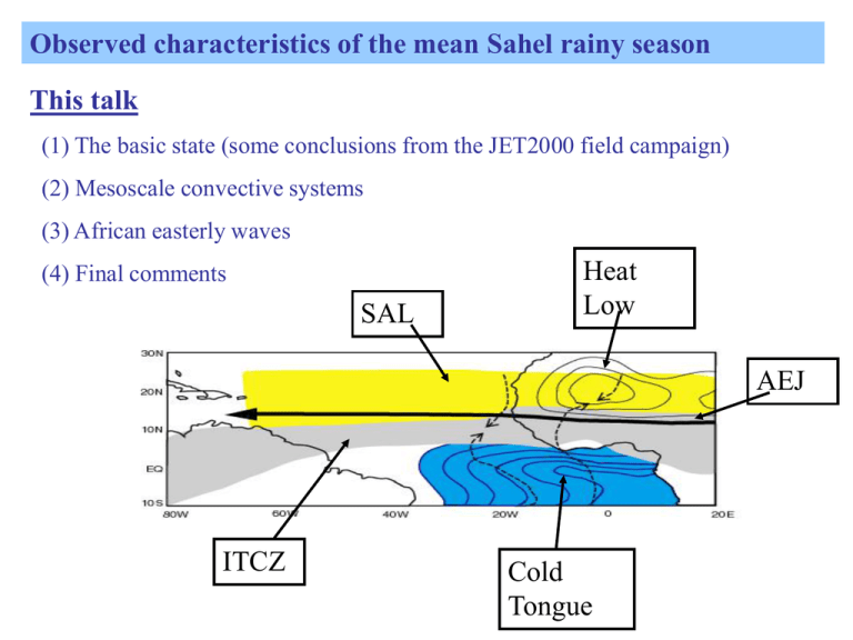
Observed characteristics of the mean Sahel rainy season This talk (1) The basic state (some conclusions from the JET2000 field campaign) (2) Mesoscale convective systems (3) African easterly waves (4) Final comments SAL Heat Low AEJ ITCZ Cold Tongue JET2000: Experimental Details • C130 aircraft flew 4 legs over this region: 25-30 August 2000 • Dropsondes every 0.51 degree • Low level flights on north-south transect Met Office C-130 At Niamey Airport, Niger Zonal Wind 28th August 2000 Thermodynamic Profiles 28th August 2000 Thermodynamic Profiles 28th August 2000 Thermodynamic Profiles 28th August 2000 Height of AEJ 8N 10 N 12 N 15 N 18 N Static stability 28th August 2000 - 3 LAYERS Upper Troposphere Saharan Air Layer Monsoon Layer Lifting Condensation Level Mixed Layer Schematic of African Easterly Jet AEJ 90oC θe 60oC θe θ 50oC θ 20oC Diurnal Cycle of heat low circulation Sections based on Met Office analyses/forecasts. The monsoon flow is active at night and in the morning. Parker et al, (2005) QJRMS Conclusions from JET2000 Field Campaign (1) To first order the AEJ is balanced – with the temperature field strongly linked to surface conditions and to variations in mean convection Cook (1999), Nicholson (1998), Thorncroft and Blackburn (1999), Parker et al (2005a) (2) The AEJ is characterised by distinctive layers with different thermodynamic characteristics: Monsoon layer, strongly impacted by surface features and diurnal forcing Saharan Air Layer, dry, dusty, low PV air that likely influences the northern part of the rainy zone Parker et al (2005a), Hamilton and Archbold (1945) (3) The heat low circulation is characterised by a marked diurnal cycle that impacts water vapour transport in the monsoon. Parker et al (2005b), see also Racz and Smith (1999) To what extent do climate models need to represent these characteristics of the monsoon correctly? Models can have problems with intensity of heat low Intensity of heat low is likely impacted by radiative effects linked to presence of aerosol (Jim Haywood, Met Office). Modeled heat low is sensitive to the way aerosol is represented. Data from SINERGEE project using 6Z, 12Z, 18Z, 24Z, July 2003 The +ve anomaly over desert is ~ -ve anomaly over ITCZ clouds Key weather systems that characterize the monsoon SAL TC AEWs MCSs (2) Mesoscale Convective Systems TRMM based MCS climatology over Africa and tropical Atlantic for June-July-August Rainfall Percentage of MCSs with significant ice scattering Stratiform Rain Fraction Average Lightning flash density Schumacher and Houze (2006) QJRMS : Less stratiform rain over sub-Saharan Africa than Atlantic but, Stratiform rain increases in monsoon season compared to pre-monsoon season due to (i) reduced upper-level shear?, (ii) reduced impact of dry SAL?, (iii) other? (2) Mesoscale Convective Systems • MCSs are the main rain producers in the region. • Their structures vary regionally and during the season. Most importantly this includes the relative contributions from convective and stratiform rain as well as non-precipitating anvil. How do these regional and seasonal variations impact the regional radiation budget? How do these variations impact the regional diabatic heating profiles and associated circulations? (3) African Easterly Waves AEWs are synoptic structures associated with perturbations to the AEJ and usually have embedded MCSs. In climate studies we often filter fields to highlight just the synoptic scale aspects of the waves. But intensity of waves is likely to depend on their interactions with the MCSs. Berry, G. and Thorncroft, C.D. (2005) MWR Berry, G, Thorncroft, C.D. and Hewson, T. (2007) MWR OLR and 850 hPa Flow Regressed against TD-filtered OLR (scaled -20 W m2) at 10N, 10W for June-September 1979-1993 Day 0 Streamfunction (contours 1 X 10⁵ m2 s-1) Wind (vectors, largest around 2 m s-1) OLR (shading starts at +/- 6 W s-2), negative blue Kiladis, G, Thorncroft, C.D. and Hall, N. (2006) JAS OLR and 850 hPa Flow Regressed against TD-filtered OLR (scaled -20 W m2) at 10N, 10W for June-September 1979-1993 Day-4 Streamfunction (contours 1 X 10⁵ m2 s-1) Wind (vectors, largest around 2 m s-1) OLR (shading starts at +/- 6 W s-2), negative blue OLR and 850 hPa Flow Regressed against TD-filtered OLR (scaled -20 W m2) at 10N, 10W for June-September 1979-1993 Day-3 Streamfunction (contours 1 X 10⁵ m2 s-1) Wind (vectors, largest around 2 m s-1) OLR (shading starts at +/- 6 W s-2), negative blue OLR and 850 hPa Flow Regressed against TD-filtered OLR (scaled -20 W m2) at 10N, 10W for June-September 1979-1993 Day-2 Streamfunction (contours 1 X 10⁵ m2 s-1) Wind (vectors, largest around 2 m s-1) OLR (shading starts at +/- 6 W s-2), negative blue OLR and 850 hPa Flow Regressed against TD-filtered OLR (scaled -20 W m2) at 10N, 10W for June-September 1979-1993 Day-1 Streamfunction (contours 1 X 10⁵ m2 s-1) Wind (vectors, largest around 2 m s-1) OLR (shading starts at +/- 6 W s-2), negative blue OLR and 850 hPa Flow Regressed against TD-filtered OLR (scaled -20 W m2) at 10N, 10W for June-September 1979-1993 Day 0 Streamfunction (contours 1 X 10⁵ m2 s-1) Wind (vectors, largest around 2 m s-1) OLR (shading starts at +/- 6 W s-2), negative blue OLR and 850 hPa Flow Regressed against TD-filtered OLR (scaled -20 W m2) at 10N, 10W for June-September 1979-1993 Day+1 Streamfunction (contours 1 X 10⁵ m2 s-1) Wind (vectors, largest around 2 m s-1) OLR (shading starts at +/- 6 W s-2), negative blue OLR and 850 hPa Flow Regressed against TD-filtered OLR (scaled -20 W m2) at 10N, 10W for June-September 1979-1993 Day+2 Streamfunction (contours 1 X 10⁵ m2 s-1) Wind (vectors, largest around 2 m s-1) OLR (shading starts at +/- 6 W s-2), negative blue OLR and 850 hPa Flow Regressed against TD-filtered OLR (scaled -20 W m2) at 10N, 10W for June-September 1979-1993 Day+3 Streamfunction (contours 1 X 10⁵ m2 s-1) Wind (vectors, largest around 2 m s-1) OLR (shading starts at +/- 6 W s-2), negative blue OLR and 850 hPa Flow Regressed against TD-filtered OLR (scaled -20 W m2) at 10N, 10W for June-September 1979-1993 Day+4 Streamfunction (contours 1 X 10⁵ m2 s-1) Wind (vectors, largest around 2 m s-1) OLR (shading starts at +/- 6 W s-2), negative blue OLR and 850 hPa Flow Regressed against TD-filtered OLR (scaled -20 W m2) at 10N, 10W for June-September 1979-1993 Day+5 Streamfunction (contours 1 X 10⁵ m2 s-1) Wind (vectors, largest around 2 m s-1) OLR (shading starts at +/- 6 W s-2), negative blue (3) African easterly waves • African easterly waves are the major synoptic perturbations to the African easterly jet. • They impact the transport of moist and dry air at the synoptic scale and hence have a coherent relationship with convection (including MCSs). • Rainfall tends to lead the AEJ-level trough over the land and follow it over the ocean. Do climate models need to accurately depict African easterly waves and their relationship with clouds and rainfall? (4) Final comments • The West African Monsoon has a marked seasonal cycle often characterised by a so-called “jump”. Models, in general, do not handle this subtlety of the monsoon (see Janicot et al). • The WAM is characterised by marked wet and dry spells but the mechanisms that explain these are not well understood. Possible candidates include land surface feedbacks and intraseasonal oscillations including MJO (see Sultan and Janicot, 2007) (4) Final comments • This presentation has focused on observed characteristics of the West African Monsoon that are clearly important for forecasting efforts at short to medium range. • To what extent must these be well represented in models used for climate prediction, either explicitly or through parameterizations? AMMA Field Programme See http://www.amma-international.org
