STATISTICAL AREAS LEVEL 1 (SA1s) What are SA1s?
advertisement
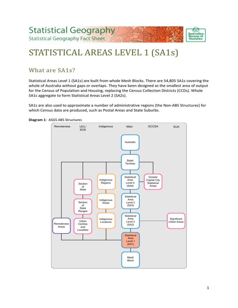
STATISTICAL AREAS LEVEL 1 (SA1s) What are SA1s? Statistical Areas Level 1 (SA1s) are built from whole Mesh Blocks. There are 54,805 SA1s covering the whole of Australia without gaps or overlaps. They have been designed as the smallest area of output for the Census of Population and Housing, replacing the Census Collection Districts (CCDs). Whole SA1s aggregate to form Statistical Areas Level 2 (SA2s). SA1s are also used to approximate a number of administrative regions (the Non-ABS Structures) for which Census data are produced, such as Postal Areas and State Suburbs. Diagram 1: ASGS ABS Structures Remoteness UCL/ SOS Indigenous Main GCCSA SUA Australia State/ Territory Section of State Section of State Ranges Remoteness Areas Urban Centres and Localities Indigenous Regions Statistical Area Level 4 (SA4) Indigenous Areas Statistical Area Level 3 (SA3) Indigenous Locations Statistical Area Level 2 (SA2) Greater Capital City Statistical Areas Significant Urban Areas Statistical Area Level 1 (SA1) Mesh Block 1 Diagram 2: Non-ABS Structures ABS Structures Statistical Area Level 2 (SA2) Non - ABS Structures Tourism Regions (TR) Postal Areas (POA) State Suburbs (SSC) Commonwealth Electoral Divisions (CED) State Electoral Divisions (SED) Australian Drainage Divisions (ADD) Natural Resource Management Regions (NRMR) Statistical Area Level 1 (SA1) Mesh Blocks Local Government Areas (LGA) How are SA1s different from Collection Districts (CDs)? SA1s are specifically designed as an output region for Census data, whereas Collection Districts were designed primarily as a work load region for a Census Collector. There are more SA1s than CDs: there are 54,805 SA1s in 2011 compared to 38,704 CDs in 2006. They have a more consistent population size than CDs – on average they have a population of approximately 400 people, and most are designed to be within the population range 200 - 800 people. SA1s in rural and remote areas generally have lower populations than in urban areas. Similar to CDs, SA1s are designed to have either a predominantly rural or predominantly urban character. They are designed to be internally connected by road, except for groups of unpopulated islands. Unlike CDs, SA1s do not necessarily align to Local Government Area boundaries, although the SA1s do closely reflect them. SA1s more closely align to gazetted suburbs and localities than did CDs. Like CDs, SA1s identify townships with a population of 180 persons or more and discrete Indigenous communities with a population of 90 persons or more. Areas without permanent population (such as lakes, commercial areas, national parks etc.) are often represented by "zero SA1s" - these are SA1s with an effective design population of zero. 2 How does this change affect time series? CD and SA1s were designed using very different criteria, resulting in considerable differences between the two. In general, it is not possible to make a comparison between CDs and SA1s, but there are particular circumstances where it may be possible. These include: Small rural townships: although the CD boundaries and the SA1 boundaries may be quite different, they were both designed to contain the same population and will in most cases be largely comparable. Indigenous communities: although the CD boundaries and the SA1 boundaries may be quite different they were both designed to contain the same population and will therefore be comparable. Other than in the situations similar to those described above, there is a break in CD-based time series data. To assist users of CD time series collections, the ABS is providing a correspondence of 2006 CD to 2011 SA1s together with an index of fitness for purpose. Identified issues surrounding the use of correspondences are discussed in detail in the ABS publication Information Paper: Converting Data to the Australian Statistical Geography Standard, 2011 (cat. no. 1216.0.55.004). A suite of geographical correspondences are located in the following online publication under the ‘Downloads’ tab: Australian Statistical Geography Standard (ASGS): Correspondences, July 2011 (cat. no. 1270.0.55.006). An additional resource, a ‘Time Series’ fact sheet, is available from the ‘ASGS Fact Sheets’ chapter of the ABS Statistical Geography web site: http://www.abs.gov.au/geography Where can I get the SA1 boundaries? The SA1 boundaries are available in MapInfo Interchange and ESRI Shapefile formats and can be downloaded from the ‘ABS Geography Publications’ chapter of the ABS Statistical Geography website: http://www.abs.gov.au/geography Alternatively, SA1 digital boundaries are available through the ‘Downloads’ tab of the ASGS Main Structures online publication: Australian Statistical Geography Standard (ASGS): Volume 1 - Main Structure and Greater Capital City Statistical Areas, July 2011 (cat. no. 1270.0.55.001). The publication includes a manual that includes a discussion of SA1s and the criteria used in their design, maps of the main structure regions of SA2 and above, and complete lists of the various regions of the ASGS and their hierarchical relationships. Where can I get further information? More information on the ASGS and ABS Statistical Geography can be found by visiting the ABS website: http://www.abs.gov.au/geography Any questions or comments can be emailed to geography@abs.gov.au 3
