GEOLOGY, GROUNDWATER, AND GEOLOGIC HAZARDS IN THE ALBUQUERQUE BASIN, NEW MEXICO
advertisement
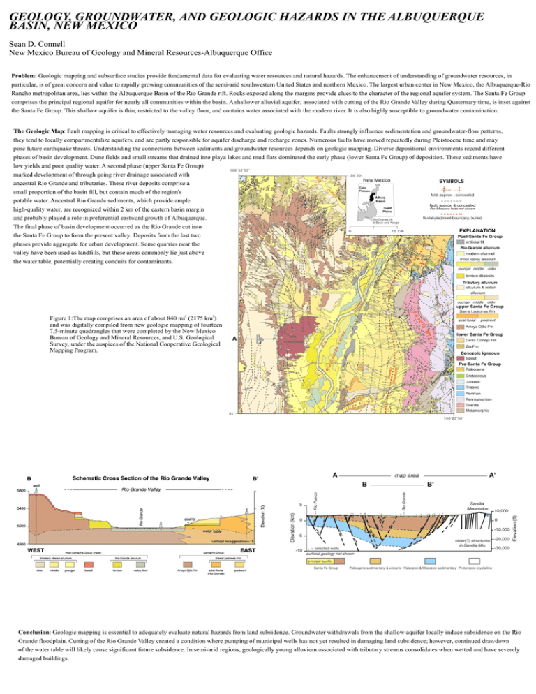
GEOLOGY, GROUNDWATER, AND GEOLOGIC HAZARDS IN THE ALBUQUERQUE BASIN, NEW MEXICO Sean D. Connell New Mexico Bureau of Geology and Mineral Resources-Albuquerque Office Problem: Geologic mapping and subsurface studies provide fundamental data for evaluating water resources and natural hazards. The enhancement of understanding of groundwater resources, in particular, is of great concern and value to rapidly growing communities of the semi-arid southwestern United States and northern Mexico. The largest urban center in New Mexico, the Albuquerque-Rio Rancho metropolitan area, lies within the Albuquerque Basin of the Rio Grande rift. Rocks exposed along the margins provide clues to the character of the regional aquifer system. The Santa Fe Group comprises the principal regional aquifer for nearly all communities within the basin. A shallower alluvial aquifer, associated with cutting of the Rio Grande Valley during Quaternary time, is inset against the Santa Fe Group. This shallow aquifer is thin, restricted to the valley floor, and contains water associated with the modern river. It is also highly susceptible to groundwater contamination. The Geologic Map: Fault mapping is critical to effectively managing water resources and evaluating geologic hazards. Faults strongly influence sedimentation and groundwater-flow patterns, they tend to locally compartmentalize aquifers, and are partly responsible for aquifer discharge and recharge zones. Numerous faults have moved repeatedly during Pleistocene time and may pose future earthquake threats. Understanding the connections between sediments and groundwater resources depends on geologic mapping. Diverse depositional environments record different phases of basin development. Dune fields and small streams that drained into playa lakes and mud flats dominated the early phase (lower Santa Fe Group) of deposition. These sediments have low yields and poor quality water. A second phase (upper Santa Fe Group) marked development of through going river drainage associated with ancestral Rio Grande and tributaries. These river deposits comprise a small proportion of the basin fill, but contain much of the region's potable water. Ancestral Rio Grande sediments, which provide ample high-quality water, are recognized within 2 km of the eastern basin margin and probably played a role in preferential eastward growth of Albuquerque. The final phase of basin development occurred as the Rio Grande cut into the Santa Fe Group to form the present valley. Deposits from the last two phases provide aggregate for urban development. Some quarries near the valley have been used as landfills, but these areas commonly lie just above the water table, potentially creating conduits for contaminants. 2 2 Figure 1:The map comprises an area of about 840 mi (2175 km ) and was digitally compiled from new geologic mapping of fourteen 7.5-minute quadrangles that were completed by the New Mexico Bureau of Geology and Mineral Resources, and U.S. Geological Survey, under the auspices of the National Cooperative Geological Mapping Program. Conclusion: Geologic mapping is essential to adequately evaluate natural hazards from land subsidence. Groundwater withdrawals from the shallow aquifer locally induce subsidence on the Rio Grande floodplain. Cutting of the Rio Grande Valley created a condition where pumping of municipal wells has not yet resulted in damaging land subsidence; however, continued drawdown of the water table will likely cause significant future subsidence. In semi-arid regions, geologically young alluvium associated with tributary streams consolidates when wetted and have severely damaged buildings.


