MONITORING RANGE- LAND BROWSE
advertisement
MONITORING RANGELAND BROWSE
VEGETATION
George Ruyle1 and Bill Frost 2
Rangeland vegetation monitoring is a
useful tool to detect changes in plant
communities induced by management
practices and/or natural processes.
Information obtained through vegetation
monitoring can be used to determine if
management goals are being met and to
adjust management practices if needed.
There are many attributes of plant
communities that may be monitored, but
not all of these are useful to interpret or
feasible to measure. The appropriateness of a particular attribute depends
upon the vegetation type (e.g. shrubs or
grasses) and the management goals for
which the data will be interpreted.
Some of the important measurable
attributes of shrub communities are:
1.
density - the number of individual
plants per unit area.
2.
cover - an expression of the soil
surface which is overhung
(covered) by either the plant
crown and shoot (canopy) or
encountered by basal stems
(basal cover).
3.
age and form class - age classes
consisting of seedling, young,
sprout, mature and decadent
(25% or greater dead wood) and
the degree of hedging (form
class) describing the availability of
the shrub to browsing animals
and the degree of hedging the
plant has received.
Rangeland Management
There are a variety of other plant
attributes such as height, stem diameter, leader length, and biomass, but
for shrub dominated rangeland, density,
canopy cover and age and form class
are those which can be measured and
interpreted for analysis for resource
managers. Belt transects are used to
determine density and age and form
class, and line-intercept data are
collected to estimate canopy cover.
Belt transects are merely two-dimensional, very long rectangular plots. The
line-intercept method is based on the
principle of reducing the belt-transect
with dimensions of length and width to
a line with only one dimension; length.
DENSITY & AGE AND
FORM CLASS
Determining plant density is accomplished by counting the number of
individuals in a known area. Density
counts should be kept by species, and
by age and form class within species.
The age classes give a representation
of the diversity present in the shrub
community and the form classes
represent the amount of use the shrubs
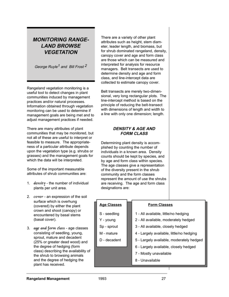
are receiving. The age and form class
designations are:
Age Classes
Form Classes
S - seedling
1 - All available, little/no hedging
Y - young
2 - All available, moderately hedged
Sp - sprout
3 - All available, closely hedged
M - mature
4 - Largely available, little/no hedging
D - decadent
5 - Largely available, moderately hedged
6 - Largely available, closely hedged
7 - Mostly unavailable
8 - Unavailable
1993
27
These data can be collected, for
example, by establishing a 100 foot
transect and recording the plants
present (species, age and form class)
along a belt 6 feet on either side of the
100 foot tape (12 foot width total). The
results can easily be converted to
plants per acre on either a species, age
and form class, or age and form class
within species basis. The length of the
transect and width of belt will vary
depending upon the shrub community
to be measured. Where shrubs are
numerous, smaller transects and belts
may be used whereas sparse shrub
communities will require larger sampling units. As a general rule, 20 to 30
individual shrubs of the target species
should be contained within the belt
transect.
PLANT COVER
has two dimensions and reducing it to
one dimension; length. This line
consists of a tape laid out on the
ground on the center of the belt
transect and the plant crowns that
overlap or intercept the line are recorded by species. The beginning and
end of where the canopy overhangs the
tape is recorded and later converted to
percent cover. Where plant canopy
gaps occur within individual shrubs,
rounding out canopy edges and filling in
interval gaps is recommended (Figure
1). The line-intercept is most useful
where cover assessment of a large
area is required.
These methods may be modified based
on attributes of specific plant communities and objectives for the analysis. But
for general estimates of shrub numbers
and cover some form of belt and line
intercept transects are efficient and
reliable sampling methods.
Usually cover is defined as the vertical
projection of the crown or shoot area of
a plant to the ground surface expressed
as a fraction or a percent of a reference
area (canopy cover). Cover may also
apply to the basal area in relation to
ground surface (basal cover). The
basal area is the area outline of a plant
near the soil surface.
Cover as a measure of plant distribution is often considered as being of
greater ecological significance than
density, largely because cover gives a
better measure of plant biomass than
does the numbers of individuals. Also
very important is the relationship of
plant cover to the potential for soil
erosion.
Rangeland Management
6 ft
{
{
A fast and efficient way to
estimate shrub canopy
cover over large areas of
rangeland is with the lineintercept method. As
mentioned earlier, the lineintercept method is based
on the belt transect, a long,
rectangular quadrat, which
6 ft
Tape - 100 ft
Figure 1. Where gaps occur within plant canopies along the tape, visual projections
of edges and gaps are required.
1993
28
THE BASIC PROCEDURES
1. Select monitoring location.
2. Establish rain gauge.
3. Establish transect end points with
EQUIPMENT
1. 100 ft or 30 m tape (longer if
vegetation is very sparse)
2. stakes for transect end points
3. springs for each end of tape
permanent stakes.
(optional)
4. Establish photo point (take picture)
4. photo ID placard
5. To read transect:
5. metal fence post
a. record positions along tape
where shrub canopies intercept
line.
b. walk along tape holding a 12 ft
pole horizontally to transect so 6
ft project on each side of line.
Count and record the number of
shrubs in each species of
interest in one of the age and
form classes. The length of
pole may be variable, depending on the shrub community to
be measured. Sampling poles
can be made of PVC segments
to fit together into various
lengths.
6.
PVC pipe, capped to serve as rain
gauge (add inch or so of oil to limit
evaporation)
7. 12 ft pole (or other chosen length)
8. data forms (example in figure 3).
}
Record
Entire Intercept
Tape
Figure 2. Diagram of line-intercept and belt transect indicating shrub
cover and density. Dotted line represents imaginary boundaries
created by moving pole down center line.
Rangeland Management
1993
29
Location:
Species
Actual
Intercept
Total
Total
Inches
Species
Actual
Intercept
Total
Inches
Age &
Form
Class
Total
Inches
Age &
For
Class
Line Intercept Transect
Species
Actual
Intercept
Length:
Species
Actual
Intercept
Total
Inches
Transect No.
Age &
Form
Class
Actual
Intercept
Species
Examiner
Figure 3. Example of a data form used to record density, cover and growth form data.
Age &
Form
Class
Age &
Form
Class
Date
Total
Inches
30
1993
Rangeland Management
Range Management Specialist1
School of Renewable Natural Resources
College of Agriculture
The University of Arizona
Tucson, Arizona 85721
FROM:
Arizona Ranchers' Management Guide
Russell Gum, George Ruyle, and Richard Rice, Editors.
Arizona Cooperative Extension
Disclaimer
Neither the issuing individual, originating unit, Arizona Cooperative Extension, nor the Arizona Board of
Regents warrant or guarantee the use or results of this publication issued by Arizona Cooperative
Extension and its cooperating Departments and Offices.
Any products, services, or organizations that are mentioned, shown, or indirectly implied in this
publication do not imply endorsement by The University of Arizona.
Issued in furtherance of Cooperative Extension work, acts of May 8 and June 30, 1914, in cooperation with
the U.S. Department of Agriculture, James Christenson, Director, Cooperative Extension, College of
Agriculture, The University of Arizona.
The University of Arizona College of Agriculture is an Equal Opportunity employer authorized to provide
research, educational information and other services only to individuals and institutions that function
without regard to sex, race, religion, color, national origin, age, Vietnam Era Veteran’s status, or
handicapping conditions.
Rangeland Management
1993
31
Rangeland Management
1993
32
