Yellowstone to Yukon - The whole big scary picture
Yellowstone to Yukon - The whole big scary picture!
The Wildlands Project: An Introduction
Little known outside of the environmental movement, The Wildlands Project is the most ambitious, and far reaching attempt yet to reinvent the North American continent according to ecologically correct guidelines. Under this proposal, 50 percent of North America would be preserved or restored to wilderness for the preservation of biological diversity. However implausible their goal may seem, The
Wildlands Project is well developed, well organized, and well financed.
Based upon the work of freelance conservation biologist, Reed Noss, the cornerstone of the project consist of creating "reserve networks" across North America to provide vast areas of wildlife habitat. The goal is to maximize biological diversity across the landscape, unfortunately often at the expense of the human occupants.
The Wildlands Project requires not only a re-thinking of science, politics, land use, industrialization, and civilization, it also requires re-thinking humanity’s place in nature. It requires a new philosophical and spiritual foundation for western civilization.
That foundation is the ecophilosophy of deep ecology. Deriving much of its ideology from Buddhism and Taoism, and the philosophy of Spinoza, deep ecology contends that science has little to tell us about living in harmony with the planet, and other non-human life forms.
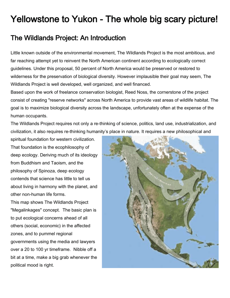
This map shows The Wildlands Project
"Megalinkages" concept. The basic plan is to put ecological concerns ahead of all others (social, economic) in the affected zones, and to pummel regional governments using the media and lawyers over a 20 to 100 yr timeframe. Nibble off a bit at a time, make a big grab whenever the political mood is right.
This map gives a sense of how the Wildlands Project and their Y2Y spin-off have drawn a bull's-eye on the Crowsnest Pass / Flathead / Elk Valley. You can also see that the project is quite ambitious, setting aside about 1/2 of the province of British Columbia conservation areas to "connect the dots" between existing federal parks. These guys don't really seem to care that their plan lacks legitimate and peer reviewed fact, and that the plan would severely curtail personal freedoms and a way of life that has been practiced responsibly for decades.
As explained in the
"Skeptical
Environmentalist", our society is increasing in environmental awareness and things are very much improving in many measurable ways.
Most enviro groups are still our social conscience, but we must be careful not to jump on emotional campaigns without first examining the facts.
The sky is NOT falling.
I hope that this page will serve as a starting point in your personal search for the truth, please evaluate ALL claims with a critical eye.
I hope this drives the point home to those who live and recreate in the Crowsnest Pass. The two yellow arrows are located at the Alberta-BC border on the right, and run directly through the town of Fernie on the left.
Fernie's Mayor is a strong proponent of a westward extension of Waterton Lakes
National Park. Tembec's Quebecbased president also supports the park expansion (thanks to
CPAWS money). Similar views are shared by a few key federal and provincial government employees who don't necessarily follow the policies of the government of the day. We can elect a sensible government, but they won't hold power forever.
The Regional District of East
Kootnay, the Districts of
Sparwood and Elkford and
Alberta's Crowsnest Pass have all come out strongly against any new parks. The same is true of most industry and nearly all backcountry user groups.
The picture below was in a calendar my son brought home from school, produced by the Western
Canada Wilderness Committee. The caption reads "Hunting and habitat loss killing majestic bears".
An inset goes on to say
"Designated as vulnerable in
1991, grizzlies are sensitive to human interference and prefer large unfragmented tracts of wilderness. In
BC, the province with the largest grizzly population in Canada, hunting is a primary threat. In 2001, the new provincial
Liberal government reinstated the grizzly-bear hunt despite overwhelming public opposition to the trophy hunting of this reclusive animal. Indefensible from a biological standpoint, the hunt makes no economic sense, as grizzly viewing generated over twice the revenue of hunting. As one of the slowest reproducing land mammals in North America, it appears unlikely that the grizzly bear will be able to survive both habitat loss and trophy hunting.".
Important facts: According to MOF bear expert Dr. Bruce McLellan, the reproduction rate of the 178 grizzly bears in the Flathead and Wigwam is 8%, much higher than the rest of the province. The humancaused mortality even before the politically motivated NDP closure in 2001 was 3.36%. With an average natural lifespan (including hunting) of more than 20 years, its pretty easy to see how the government came to the conclusion that the NDP were not operating based on scientific fact when they closed the hunt without research or public consultation.
Bottom line, the bears population in this region is healthier than in any place in the province of BC. New restrictions imposed by the Southern Rocky Mountains Management plan will not likely have measurable effect on population, yet extreme preservationists continue to push for a new federal park.
Here's how Y2Y fits into The Wildlands Project. For the sake of bears, the goal is to fill in all the spaces between the green
This is one of the pictures that motivate the preservationists. They see this "little strip of land" as the only thread connecting the Yukon to the Yellowstone. The picture comes from the Wildlife Conservation
Society's "Transboundary Flathead" marketing document.
This is just an ordinary road map of SW Alberta. What's significant is that in the 2 years since its printing they've added the Don Getty Wildlands Park South of Kananaskis, chipping away at the top of the C5
(Crowsnest Forest). The proposed Flathead expansion to Waterton Park, known as "Peace Park Plus" sort of sticks out in the SE corner of BC. This map does NOT show the Elk Lakes and Height of the
Rockies parks in BC that connect the dots on the BC side. The map also gives no appreciation of the 7 access management areas (AMAs) that "protect" the Upper Elk Valley from public access.
A province-independent version of how the Y2Y guys see SW Alberta and SE BC. This map shows the recently added Don Getty Wildlands Park (2002), Bob Creek Wildlands Park (2001), Height of the
Rockies provincial Park (1995), Elk Lakes provincial Park (1979), , Whiteswan Lake provincial park, Top of the World provincial park, and Akamina-Kishenena provincial park. The East Kootenays boast well over 16% in "protected" areas compared to the provincial average of 12%. The spaces between the green are connected by a series of access management areas (AMAs) that are closed to motorized recreation.
We should be protecting our natural resources FOR the public, not FROM the public.
The "Wildlife Conservation Society" features noted biologist John Weaver (the guy whose screwed-up lab results triggered the Oregon lynx scandal in the U.S.). This picture is interesting because it significantly expands both Glacier National Park in the US (to the West), and has a much larger area of interest than the proposed Waterton - Flathead "Peace Park" into SE BC.
MOF bear expert Dr. Bruce McLellan was recently observed working with WCS contractors in the
Alexander Creek area. The team was looking to prove that bears do not cross Hwy 3. The WCS is affiliated with, and funded by the Bronx Zoo.
This picture shows what the Castle-Crown Wilderness Society and CPAWS would like to see eventually turned into a National Park, or at least closed to the motorized public. Lawyers from the US based
Natural Resources Defence Council (NRDC) is suing the municipality of Pincher Creek for their ski hill expansion in this area causing the MD to adopt a very preservation oriented stance on land-use in the area.
This picture was given to us by a Montana State Senator. The numbers in the counties indicate the percentage of private land against which the Nature Conservancy has set caveats preventing industrial activities and most kinds of agriculture. Yellow counties are the ones where the conservancy is most active.
This map shows the wildlife management area proposed by the East Kootenay Environmental Society in
2001, and passed into law by an NDP Order in Council in their last days in control of BC. The Order in
Council called the plan the Southern Rocky Mountains Conservation Area and was created without any public input. The Liberals rescinded this plan as promised in the early fall of 2001, creating in it's place the public stakeholder process known as the Southern
Rocky Mountains Management Plan.
This map also shows lands in this part of BC owned by the Nature Conservancy. I hear through the grapevine that Nature Conservancy is about to purchase a new tract of land SW of Sparwood, North of Hosmer along the river and Hwy 3.
This picture shows the CPAWS / EKES proposed "Peace Park Plus" expansion to
Waterton National Park.
The Southern Rocky Mountains Management Plan (August 2003)
The map below shows the area affected by the recently announced Southern Rocky Mountains
Management Plan (SRMMP). This plan closes about 25% of summer trails, particularly in the sensitive
Flathead and Wigwam drainages. But it does represent the general agreement of the public stakeholders' meetings and is fundamentally a good plan, with a pretty good chance of success on the ground. The Liberal government, particularly East
Kootenay MLA Bill Bennett and SRM Minister Stan
Hagen, deserve much credit for standing up to the foreign funded lobby groups.
The Southern Rocky
Mountains Management
Plan - Snowfree (summer).
Pink areas and grey areas are closed to vehicles except main roads, red roads are specifically closed. EKES spokesperson John
Bergenske got up at a public meeting in Cranbrook in July and said "I defy anyone here to name a single road closed by this plan". I refer to exhibit A below. Note that 80% of mountain passes between AB and BC are now closed in summer, for the bears.
The Southern Rocky Mountains Management Plan - Snowbound (winter). Pink areas are closed except roads, often for "moose winter range". Some of the pink areas near Elkford and Fernie were voluntarily given by the snowmobile clubs to local cross-country ski clubs, and simply formalize a gentleman's agreement that has been in place for decades.
The thing that really sticks in my throat is that WLAP biologists have explained that the primary pressure on moose in the area is neonatal predation by bears. Are these the same bears all of this is meant to protect? I suppose we're at least protecting their food source.
Note that most of the area is still available for hunting, on foot or on horseback. This area is now well protected, but many people can no longer access areas that they have been using responsibly for decades. Not a week goes by that I don't get an earful from angry retirees who've hunted and fished and picked berries here for most of their lives.
Despite all of the new closures, many of which we reluctantly accept as responsible stewards and solution seekers, EKES and
CPAWS and WildCanada are still claiming that the Liberal government did not adequately protect the area.
Will this grassroots demonstration of responsible land management be enough
to prevent a new federal park? Will tiny groups of 3 and 5 preservationists continue to have a voice equal to local backcountry clubs with 200 and 300 members? Are all government employees without bias, or truly interested in what we pesky voters want?
We must prepare ourselves for a 50 year war, and we must keep in touch with and support our elected representatives. If all of this has you wondering how you can help, then please join your local rod & gun club, snowmobile club, ATV club, or ski club. For all our sakes, don't wait for "someone" to do something about all of this. As I so often hear, "the world is run by those who show up". And those few heroes are getting really tired and disheartened.
Further reading:
A link to the Four Amigos article (Cretien and Copps propose to give $1/4 billion to the Nature
Conservancy so they can purchase land adjacent to National Parks).
Some text from CPAWS website describing the "hole in the map" that is our backyard.
For up-to-date documents and maps of BC's Southern Rocky Mountains Management Plan, visit this page . For the summer recreation map click here , for the winter map click here .
See www.wildlandsproject.org/roomtoroam/ for their side of TWP. For a much more revealing dissertation, please see www.wildlandsprojectrevealed.org
See www.y2y.net/ to get a sense of how the Yellowstone to Yukon Conservation Initiative markets itself.
See www.wcs.org
to get a sense of who the New-York based Wildlife Conservation Society is. http://www.sacbee.com/news/projects/environment/index02.html
"Environment, Inc." -Sacramento Bee gives a sense of how
