Topographic Maps Honors
advertisement

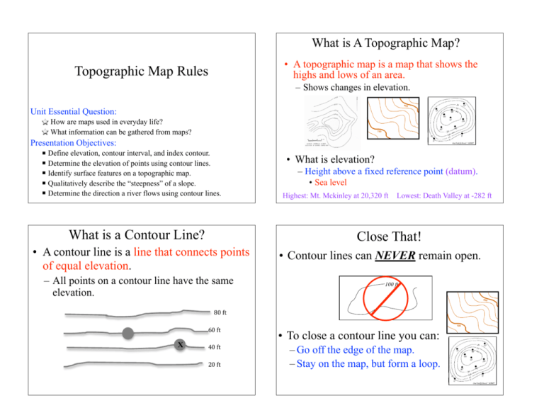
What is A Topographic Map? • A topographic map is a map that shows the highs and lows of an area. Topographic Map Rules – Shows changes in elevation. Unit Essential Question: How are maps used in everyday life? What information can be gathered from maps? Presentation Objectives: § Define elevation, contour interval, and index contour. § Determine the elevation of points using contour lines. § Identify surface features on a topographic map. § Qualitatively describe the “steepness” of a slope. § Determine the direction a river flows using contour lines. What is a Contour Line? – Height above a fixed reference point (datum). • Sea level Highest: Mt. Mckinley at 20,320 ft Lowest: Death Valley at -282 ft Close That! • A contour line is a line that connects points of equal elevation. – All points on a contour line have the same elevation. ! • What is elevation? • Contour lines can NEVER remain open. 100 ft 80!ft! X 60!ft! • To close a contour line you can: 40!ft! – Go off the edge of the map. – Stay on the map, but form a loop. 20!ft! Evenly Spaced! Using the Contour Interval • Contour lines are evenly spaced in terms of elevation. 1m 1m 2m 3m 5m 15 m 35 m 4m • The difference between two consecutive contour lines is known as the contour interval. – Typically can be found in the key/legend. ! • When a line is unmarked, you can figure out what its elevation is by using the contour interval. – You can count up from a labeled line until you reach the line you are interested in. ! 30 ft CI = 10 ft 50!ft! What’s the CI? 10 ft 0!ft! 0!ft! Being Bold! • To make it easier to read a topographic map, we don’t label every single contour line. – Every 5th contour line is labeled and bolded. – Known as the index contours. You can use the index contours to figure out the contour interval. Index Contours 800 ft -700 ft 5 = 20 ft Going In Circles • When contour lines are drawn in circles, inside the circle is HIGHER than the previous contour. – Concentric circles indicate a mountain or hill. How Steep Is It? Don’t Break The Rules! • The distance between lines tells you how steep the land is. • Contour lines can NEVER branch or fork. Close Together Steep Slope Spread Apart Gradual Slope • When the lines are close together, the same change in elevation occurs over a shorter distance. • Contour lines can NEVER cross. ! Gradual Steep • When the lines are VERY close together, there is a cliff! • When lines are VERY far apart, there is a plateau. – Perfectly horizontal can’t be drawn. Going Down? • Sometimes you have features that decrease in elevation. 150 ft You cannot be at two elevations at the same time. 100 ft What’s the elevation of this point? Exceptions: (Very Rare) • Overhanging cliff • Vertical Cliff Repeating Contours The contour lines surrounding the depression have the same elevation as the first contour of the depression. – Lakes, sinkholes, craters, etc. • These features also are circular, so we have to be able to distinguish between a hole and a hill. Hachure Marks! ! Small tick marks that point in the direction of decreasing elevation. • Everything between the ordinary contour and the hachure contour is higher than the ordinary one. • Once you reach the hachure contour, elevation begins to decrease. Repeating Contours When a depression is between contour lines that are different, the first hachure contour line has the same elevation as the lower contour line. ! A River Runs Through It! • Contour lines crossing a river form a V-shape. – The tip of the V points upstream, which means that the river is flowing in the opposite direction! All Rivers flow DOWNHILL from higher elevation to lower elevation. 260 This is the opposite direction of where the V’s point. 240 240 Not All Rivers Flow South! The Nile = North The Amazon = East This river is flowing southeast! hilltop steep area Sea level contours crossing a river.


