Earth Science – Quiz 2
advertisement
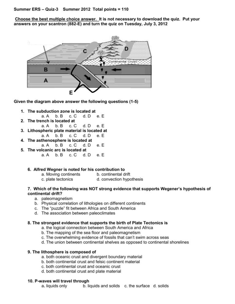
Summer ERS – Quiz-3 Summer 2012 Total points = 110 Choose the best multiple choice answer. It is not necessary to download the quiz. Put your answers on your scantron (882-E) and turn the quiz on Tuesday, July 3, 2012 C D B A E Given the diagram above answer the following questions (1-5) 1. The subduction zone is located at a. A b. B c. C d. D e. E 2. The trench is located at a. A b. B c. C d. D e. E 3. Lithospheric plate material is located at a. A b. B c. C d. D e. E 4. The asthenosphere is located at a. A b. B c. C d. D e. E 5. The volcanic arc is located at a. A b. B c. C d. D e. E 6. Alfred Wegner is noted for his contribution to a. Moving continents b. continental drift c. plate tectonics d. convection hypothesis 7. Which of the following was NOT strong evidence that supports Wegener’s hypothesis of continental drift? a. paleomagnetism b. Physical correlation of lithologies on different continents c. The “puzzle” fit between Africa and South America d. The association between paleoclimates 8. The strongest evidence that supports the birth of Plate Tectonics is a. the logical connection between South America and Africa b. The mapping of the sea floor and paleomagnetism c. The overwhelming evidence of fossils that can’t swim across seas d. The union between continental shelves as opposed to continental shorelines 9. The lithosphere is composed of a. both oceanic crust and divergent boundary material b. both continental crust and felsic continent material c. both continental crust and oceanic crust d. both continental crust and plate material 10. P-waves will travel through a. liquids only b. liquids and solids c. the surface d. solids 11. The elastic rebound theory states: a. rocks will bend and fold due to the release of stress b. rocks undergo various amounts of strain from stresses and “snap” in response to gain equilibrium c. bending of lithospheric plates results in mountains and earthquakes d. how far a rubber band will stretch 12. The Mercalli scale is known for measuring an earthquakes a. energy release b. amount of damage to an area c. wave vibrations d. motion 13. The San Andreas fault is a classic example of a. One plate diving beneath another expressing a transform boundary b. One plate sliding past another plate forming offset features c. One plate separating from another plate expressing a linear slice upon the crust d. One plate converging into another 14. In the diagram below, identify the type of fault a. Normal fault b. reverse fault c. transform fault d. joint fault 15. The fault diagram below shows a _______________ type fault a. left lateral strike slip b. right lateral strike slip c. normal fault d. reverse fault 16. If the hanging-wall moves up relative to the foot-wall, this is considered a a. reverse fault b. normal fault c. vertical fault d. your fault 17. The Pacific plate is located ___________ of the San Andreas Fault and the North American Plate is ___________ of the San Andreas Fault a. east/west b. north/south c. west/east d. south/north 18. Which of the following types of tectonic forces tends to stretch rocks and pull them apart? a. tensional forces b. sheering forces c. compressional forces d. all of these 19. Reverse faulting is associated with _________ stress and creates ________ of the earth’s crust. a. tensional, shorting b. compressional, extension c. shear, shorting d. compressional, shorting 20. Structural strain within describes: a. the amount of stress applied to a tectonic area b. the amount of compression that creates uplift c. the amount of deformation that creates faulting and folding of rocks d. the amount of bend an ankle can take before fracturing the tibia. 21. The San Andreas Fault is classified as a a. normal strike-fault b. right-lateral strike slip fault c. left lateral strike slip fault d. vertical type fault 22. Which geographical location below represents an ocean to ocean convergent boundary? a. West coast of North America b. West coast of South America c. the Himalayan Mountains d. The Island of Japan 23. Which geographical location below represents an ocean to continent convergent boundary? a. coast of Oregon and Washington b. The San Andreas Fault c. The Azores Islands d. Hawaii 24. Which geographical location below represents a continent to continent convergent boundary? a. coast of Oregon and Washington b. the Himalayan Mountains c. Hawaii d. coast of South America 25. The process of convection is defined by a. the rising and cooling of liquid material creating circular motions b. the upwelling of gasses through solid material c. heat transfer through a solid c. heat transfer within the rocks 26. The ________ is an example of an active, continent-continent collision. a. northward movement of India into Eurasia b. Arabian Peninsula slamming into North Africa under the Red Sea c. westward movement of the South American plate over the Nazca plate d. northern movement of Baja California and a sliver of western California toward the Hawaiian Islands 27. Pull-apart rift zones are generally associated with a ________ plate boundary. a. sliding plates b. converging plates c. spreading plates d. all plate boundaries 28. Linear, magnetic patterns associated with mid-ocean ridges are configured as ________. a. concentric circles about a rising plume of hot mantle rocks and magma b. normal and reversed magnetized strips roughly parallel to the ridge c. reversed paleomagnetizations along the convergent valleys and normal ridge magnetizations d. normal and reversed magnetized strips roughly perpendicular to the ridge axis 29. A typical rate of seafloor spreading in the Atlantic Ocean is ________. a. 2 mm per year b. 0.1 inches per year c. .80 in per yr d. 20 feet per yr 30. Which of the following energy sources is thought to drive the lateral motions of Earth's lithospheric plates? a. gravitational attractive forces of the Sun and Moon b. convection of heat from deep in the mantle to the top of the asthenosphere c. electrical and magnetic fields localized in the outer core d. swirling movements of the molten iron particles in the outer core through convective processes 31. New oceanic crust and lithosphere are formed at ________. a. divergent boundaries by submarine eruptions and intrusions of rhyolitic magma b. convergent boundaries by submarine eruptions and intrusions of rhyolitic magma c. convergent boundaries by submarine eruptions and intrusions of basaltic magma d. spreading ridges by submarine eruptions and intrusions of high mafic type magmas 32. Cooler, older, oceanic lithosphere sinks into the mantle at ________. a. subducted rift zones along spreading centers b. transform fault zones along divergent plate boundaries c. subduction zones along zones of plate convergence d. sites of long-lived, hot spot volcanism in the ocean basins 33. Deep ocean trenches are surficial evidence for ________. a. rifting beneath a continental plate and the beginning of continental drift b. transform faulting between an ocean to continental plate convergence c. rising of hot asthenosphere from deep in the mantle d. subduction of oceanic lithosphere into the asthenosphere at the zone of convergence 34. A transform plate boundary is characterized by ________. a. stratovolcanoes on the edge of a plate and shield volcanoes on the adjacent plate b. a deep, vertical fault along which two plates slide past one another producing off-set features c. a divergent boundary where the continental plate changes to an oceanic plate d. two converging continental plates creating a deep vertical “slice” (San Andreas Fault) 35. The volcanoes and deep valleys of east Africa are related to a ________. a. fault allowing Arabia to slip westward past east Africa and penetrate into Turkey b. continental rifting c. transform fault aligned with the Red Sea carrying the Arabian and African blocks in opposite directions d. continental collision zone between Africa and the Zagros Mountains along the southern margin of Eurasia 36. The Aleutian Islands occur at a ________. a. convergent continental margin with uplifted fault blocks. b. transform boundary where North America has moved towards Alaska c. divergent boundary where shield volcanoes are forming d. ocean to continent convergence boundary 37. Early results of the Deep Sea Drilling Project clearly justified the conclusion that ________. a. the ocean basins remain young compared to older continental lithosphere b. the oceans have not always increased in sized, but instead been replaced by continents c. Proterozoic rocks are found only as seamounts in the deepest parts of the ocean basins d.. the youngest sediments were deposited directly on the oldest seafloor basalts 38. When an earthquake occurs, energy radiates in all directions from its source. The source is also referred to as the ________. a. focus b. epicenter c. inertial point d, seismic zone 39. Which one of the following statements is correct? a. P waves travel through solids; S waves do not. b. P and S waves travel through liquids, but P waves do not travel through solids. c. P and S waves travel through liquids, but S waves promotes shearing with solid material d. S waves travel through solids and P waves bend or refract upon entering liquids. 40. ________ have the highest velocities. a. shearing waves b. compression waves c. surface waves d. refracted S waves 41. Major earthquakes are often followed by somewhat smaller events known as ________. a. tremors b. foreshocks c. aftershocks d. hyposhocks 42. The instrument that records earthquake waves is termed a ________. a. polygraph b. thermograph c. seismograph d. barograph 43. ________ is the least possible damage designation on the Mercalli scale. a. XII b. III c. X d. 10 44. The position on Earth's surface directly above the earthquake source is called the ________. a. seismic zone b. epi- point c. focus d. epicenter 45. The mechanism by which rocks store and eventually release energy in the form of an earthquake is termed ________. a. fault displacement b. potential energy c. elastic rebound d. stress fracture 46. Approximately how much more energy is released in a 6.5 Richter magnitude earthquake than in one with magnitude 5.5? a. 3000 times b. 32 times c. 300 times d. 3200 times 47. Most of our knowledge about Earth's interior comes from ________. a. propagation of P,S waves b. volcanic eruptions c. drill holes d. examination of deep mine shafts 48. Which one of the following statements about the crust is NOT true? a. It is the thinnest of the major subdivisions and dominantly mafic in composition b. Ocean crust is dominantly felsic in composition c. It is thickest where prominent mountains exist along divergent boundaries d. Continental rocks are compositionally different than oceanic rocks. Identify the following earthquake terminology in the diagram below 49 50 51 52 49. 50. 51. 52. a. focus a. focus a. focus a. focus b. epicenter b. epicenter b. epicenter b. epicenter c. seismic waves c. seismic waves c. seismic waves c. seismic waves d. fault d. fault d. fault d. fault 53. An earthquake measuring 6.3 on the Richter scale is ____________ times more powerful than an earthquake measuring 3.3 on the Richter scale. a. 1000 b. 10 c. 20 d. 100 54. There are about 600,000 earthquakes annually that range in magnitude a. Greater than M8 b.M3 c. M4 to M5 d. less than M2 55. Which of the following correctly lists the order in which seismic waves arrive at the seismograph station? a. compression waves body waves shear waves b. shear waves compression waves Surface waves c. compression waves shear waves L and R type waves d. L and R type waves shear waves S waves
