review worksheet
advertisement
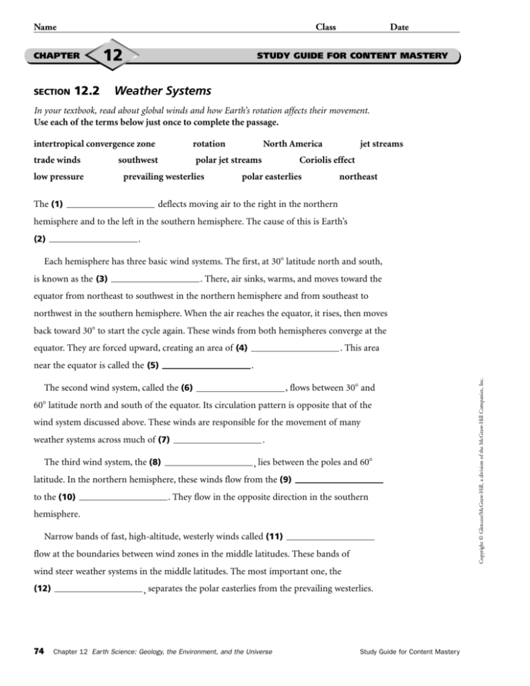
Name Class CHAPTER SECTION 12 12.2 Date STUDY GUIDE FOR CONTENT MASTERY Weather Systems In your textbook, read about global winds and how Earth’s rotation affects their movement. Use each of the terms below just once to complete the passage. intertropical convergence zone rotation trade winds polar jet streams low pressure southwest prevailing westerlies North America jet streams Coriolis effect polar easterlies northeast deflects moving air to the right in the northern The (1) hemisphere and to the left in the southern hemisphere. The cause of this is Earth’s . (2) Each hemisphere has three basic wind systems. The first, at 30 latitude north and south, is known as the (3) . There, air sinks, warms, and moves toward the equator from northeast to southwest in the northern hemisphere and from southeast to northwest in the southern hemisphere. When the air reaches the equator, it rises, then moves back toward 30 to start the cycle again. These winds from both hemispheres converge at the . This area equator. They are forced upward, creating an area of (4) The second wind system, called the (6) , flows between 30 and 60 latitude north and south of the equator. Its circulation pattern is opposite that of the wind system discussed above. These winds are responsible for the movement of many weather systems across much of (7) The third wind system, the (8) . , lies between the poles and 60 latitude. In the northern hemisphere, these winds flow from the (9) to the (10) . They flow in the opposite direction in the southern hemisphere. Narrow bands of fast, high-altitude, westerly winds called (11) flow at the boundaries between wind zones in the middle latitudes. These bands of wind steer weather systems in the middle latitudes. The most important one, the (12) 74 , separates the polar easterlies from the prevailing westerlies. Chapter 12 Earth Science: Geology, the Environment, and the Universe Study Guide for Content Mastery Copyright © Glencoe/McGraw-Hill, a division of the McGraw-Hill Companies, Inc. . near the equator is called the (5) Name Class CHAPTER SECTION 12.2 12 Date STUDY GUIDE FOR CONTENT MASTERY Weather Systems, continued In your textbook, read about fronts and wave cyclones. Complete the table by filling in the type of weather system described. Use the following terms: front, cold front, occluded front, stationary front, warm front, wave cyclone. Description Weather System 13. Cold, dense air that displaces warm air, forcing the warm air up 14. Narrow region separating two air masses of different densities 15. Advancing warm air that displaces cold air 16. Low-pressure system that heavily influences weather in the middle latitudes 17. Cold air mass that moves rapidly and overtakes a warm front 18. Two air masses that meet and do not advance In your textbook, read about pressure systems. Complete the table by checking the correct column for each statement. Statement High-Pressure System Low-Pressure System Copyright © Glencoe/McGraw-Hill, a division of the McGraw-Hill Companies, Inc. 19. Characterized by sinking air 20. Characterized by rising air 21. Air flows toward center 22. Air flows away from center 23. Air moves clockwise in the northern hemisphere 24. Air moves counterclockwise in the northern hemisphere 25. Associated with fair weather 26. Associated with clouds and precipitation Study Guide for Content Mastery Chapter 12 Earth Science: Geology, the Environment, and the Universe 75 T240 Name Class Answer Pages Earth Science: Geology, the Environment, and the Universe CHAPTER 12 Date Name 12.1 SECTION true true The Causes of Weather STUDY GUIDE FOR CONTENT MASTERY Weather Systems intertropical convergence zone rotation trade winds polar jet streams southwest low pressure 1. Meteorology is the study of atmospheric phenomena. prevailing westerlies Coriolis effect The (1) 2. Weather is the current state of the lithosphere. North America jet streams Coriolis effect polar easterlies northeast deflects moving air to the right in the northern hemisphere and to the left in the southern hemisphere. The cause of this is Earth’s 3. Long-term variations in weather for a particular area make up the (2) climate of the area. directly 12.2 Date In your textbook, read about global winds and how Earth’s rotation affects their movement. Use each of the terms below just once to complete the passage. In your textbook, read about weather and climate. In the space at the left, write true if the statement is true; if the statement is false, change the italicized word to make it true. atmosphere 12 CHAPTER STUDY GUIDE FOR CONTENT MASTERY Meteorology SECTION Class rotation . Each hemisphere has three basic wind systems. The first, at 30 latitude north and south, 4. The tropics are hotter than the poles because the sun strikes this area of Earth more indirectly. is known as the (3) trade winds . There, air sinks, warms, and moves toward the equator from northeast to southwest in the northern hemisphere and from southeast to In your textbook, read about air masses and source regions. Circle the letter of the choice that best completes the statement. northwest in the southern hemisphere. When the air reaches the equator, it rises, then moves back toward 30 to start the cycle again. These winds from both hemispheres converge at the 5. A large parcel of air that takes on the characteristics of the area over which equator. They are forced upward, creating an area of (4) it forms is a(n) a. cloud. b. air mass. c. source region. d. wind. 6. An air mass takes on its source region’s a. temperature and humidity. b. landforms. 7. Maritime air masses originate over a. clouds. b. oceans. low pressure . This area intertropical convergence zone . near the equator is called the (5) The second wind system, called the (6) prevailing westerlies , flows between 30 and 60 latitude north and south of the equator. Its circulation pattern is opposite that of the c. clouds and wind. d. elevation. wind system discussed above. These winds are responsible for the movement of many weather systems across much of (7) c. glaciers. d. mountains. The third wind system, the (8) North America . polar easterlies , lies between the poles and 60 northeast latitude. In the northern hemisphere, these winds flow from the (9) 8. When an air mass travels over land or water that has different characteristics Study Guide for Content Mastery than those of its source region, it undergoes a. air source change. b. air mass modification. to the (10) c. air pressure modification. d. temperature inversion. southwest . They flow in the opposite direction in the southern hemisphere. Narrow bands of fast, high-altitude, westerly winds called (11) jet streams flow at the boundaries between wind zones in the middle latitudes. These bands of wind steer weather systems in the middle latitudes. The most important one, the (12) polar jet stream , separates the polar easterlies from the prevailing westerlies. Study Guide for Content Mastery Chapter 12 Earth Science: Geology, the Environment, and the Universe Copyright © Glencoe/McGraw-Hill, a division of the McGraw-Hill Companies, Inc. 73 74 Chapter 12 Earth Science: Geology, the Environment, and the Universe Study Guide for Content Mastery Copyright © Glencoe/McGraw-Hill, a division of the McGraw-Hill Companies, Inc. Study Guide for Content Mastery Name Class CHAPTER SECTION 12.2 12 Date Name STUDY GUIDE FOR CONTENT MASTERY Class 12 CHAPTER Weather Systems, continued SECTION 12.3 Date STUDY GUIDE FOR CONTENT MASTERY Gathering Weather Data In your textbook, read about weather instruments. For each item in Column A, write the letter of the matching item in Column B. In your textbook, read about fronts and wave cyclones. Complete the table by filling in the type of weather system described. Use the following terms: front, cold front, occluded front, stationary front, warm front, wave cyclone. Column A Description Weather System 13. Cold, dense air that displaces warm air, forcing the warm air up cold front 14. Narrow region separating two air masses of different densities front 15. Advancing warm air that displaces cold air warm front 17. Cold air mass that moves rapidly and overtakes a warm front occluded front 18. Two air masses that meet and do not advance stationary front Answer Pages Earth Science: Geology, the Environment, and the Universe High-Pressure System Low-Pressure System 21. Air flows toward center ✓ 23. Air moves clockwise in the northern hemisphere ✓ 25. Associated with fair weather 26. Associated with clouds and precipitation a 3. An instrument that measures temperature c. anemometer b 4. An instrument that measures air pressure d. hygrometer f 5. A balloon-borne package of sensors that gathers upper-level e. ceilometer 6. An instrument that measures relative humidity f. radiosonde 7. What is the Doppler effect? How do meteorologists use it to predict weather? such as sound or light, as the energy moves toward or away from an observer. Meteorologists use Doppler radar (based on the Doppler effect) to find areas of precipitation and associated wind speeds by measuring the speed at which raindrops move toward or away from a radar station. 8. How do meteorologists combine data from weather radar and weather satellites to ✓ 24. Air moves counterclockwise in the northern hemisphere b. barometer The Doppler effect is the change in wave frequency that occurs in energy, ✓ ✓ Column B a. thermometer In your textbook, read about radar and weather satellites. Answer the following questions. 20. Characterized by rising air 22. Air flows away from center 2. An instrument that measures wind speed and direction d ✓ 19. Characterized by sinking air c weather data In your textbook, read about pressure systems. Complete the table by checking the correct column for each statement. Statement 1. An instrument that measures the height of cloud layers and estimates cloud cover wave cyclone 16. Low-pressure system that heavily influences weather in the middle latitudes e gather information about the atmosphere? ✓ Meteorologists use weather radar to track precipitation and weather satellite ✓ images to track clouds. By combining data from these two types of technology, meteorologists can determine where both clouds and precipitation are occurring. 9. What is infrared imagery? How is it used? Infrared imagery detects differences in thermal energy. These differences are used to map either cloud cover or surface temperatures. Objects that radiate warmth at slightly different frequencies show up in an infrared image as different colors. Infrared imagery is especially useful in detecting thunderstorms that show up as very cold areas on an infrared image. T241 Study Guide for Content Mastery Chapter 12 Earth Science: Geology, the Environment, and the Universe 75 76 Chapter 12 Earth Science: Geology, the Environment, and the Universe Study Guide for Content Mastery
