Print › AP Human Geography Barron's Book AP Exam Vocabulary
advertisement
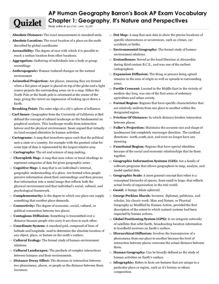
AP Human Geography Barron's Book AP Exam Vocabulary Chapter 1: Geography, It's Nature and Perspectives Study online at quizlet.com/_6jj9t 1. Absolute Distance: The exact measurement in standard units. 2. Absolute Location: The exact location of a place on the earth 20. specific observations or occurrences, such as crimes, car accidents,or births. described by global coordinates 3. Accessibility: The degree of ease with which it is possible to 21. Aggregation: Gathering of individuals into a body or group; 22. Anthropogenic: Human-induced changes on the natural environment 6. 7. Breaking Point: The outer edge of a city's sphere of influence. 8. Carl Sauer: Geographer from the University of California at Bed defined the concept of cultural landscape as the fundamental un graphical analysis. This landscape results from interaction betwee and the physical environment. Sauer argued that virtually no land escaped alteration by human activities. 9. 23. 24. 10. Cartography: The art and science of map making. 11. Choropleth Map: A map that uses colors or tonal shadings to represent categories of data for given geographic areas. 12. 25. 13. Complementarity: Is the degree to which one place can supply 26. Friction Of Distance: In which distance hinders interaction 27. Fuller's Projection: Maintains the accurate size and shape of between places. landmasses but completely rearranges direction. The cardinal directions- north,south,east, and west-no longer have any meaning. 28. 29. 30. 16. 31. Geoid: A bumpy oblate spheroid. 32. George Perkins Marsh: Inventor, diplomat, politician, and scholar, his classic work, Man and Nature, or Physical Geography as Modified by Human Action, provided the first description of the extent to which natural systems had been impacted by human actions. Contagious Diffusion: Something is transmitted over a 17. 33. 34. Cultural Landscapes: The products of complex interactions between humans and their environments. 19. Distance Decay Effect: The decrease in interaction between two phenomena, places, or people as the distance between them increases. Hierarchical Diffusion: Involves the transmission of a phenomena from one place to another because the level of interaction between places overcome the actual distance between them. Cultural Ecology: The formal study of human-environment relations. 18. Global Positioning System (GPS): Is an integrate networks of satellites that orbit Earth, broadcasting location information to handheld receivers on Earth's surface. Coordinate System: A standard grid, composed of lines of latitude and longitude, used to determine the absolute location of any object, place, or feature on the earth's surface. Geographic Scale: A more general concept that refers to a conceptual hierarchy of spaces, from small to large, that reflects actual levels of organization in the real world. Connectivity: The degree of economic, social, cultural, or distance because people who carry it are close to each other. Geographic Information Systems (GIS): Are a family of software programs that allows geographers to map, analyze, and model spatial data. political connection between two places 15. Functional Region: Regions that have special identities because of the social and economic relationships that tie them together. something that another place demands. 14. Formal Region: Regions that have specific characteristics that are relatively uniform from one place to another within the designated region. Cognitive Map: A map that is an individual's internal, geographic understanding of a place. Are formed when people perceive information about their surroundings and then process that information into a metal image that reflects both the physical environment and that individual's social, cultural, and psychological framework. Fertile Crescent: Located in the Middle East in the vicinity of modern-day Iraq, was one of the first areas of sedentary agriculture and urban society. Cartograms: A map that transform space such that the political unit-a state or a country, for example-with the greatest value for some type of data is represented by the largest relative area. Expansion Diffusion: The thing or process being spread remains in the area of origin as well as spreads to surrounding areas. Azimuthal Projection: Are planar, meaning they are formed when a flat piece of paper is placed on top of the globe and a light source projects the surrounding areas on to a map. Either the North Pole or the South pole is orientated at the center of the map, giving the viewer an impression of looking up or down a Earth. Eratosthenes: Served as the head librarian at Alexandria during third century B.C.E., and was one of the earliest cartographers. assemblage 5. Environmental Geography: The formal study of humanenvironment relations. reach a certian location from other locations. 4. Dot Map: A map that uses dots to show the precise locations of 35. Human Geography: Can be broadly defined as the study of 36. Idiographic: Refers to facts ore features that are unique to a human activities on Earth's surface. particular place or region, such as it's history or ethnic composition. 37. International Date Line: An arc that for the most part follows 180° longitude, although it deviates in several places to avoid dividing land areas. When you cross the International Date Line heading east (toward America), the clock moves back 24 hours, or one entire day. When you go west (toward Asia), the calendar moves ahead one day. 38. 39. Isoline: Lines that represent quantities of equal value on a map. 40. Large Scale: Have large scale ratios. 41. Latitude: Distance north or south of the Equator, measured in degrees. 43. 44. 58. 59. Quantitative Approaches: Use rigorous mathematical techniques and are particularly important in economic, political, and population geography where hard, numerical data abounds. 60. Quantitative Revolution: A period in human geography associated with the widespread adoption of mathematical models and statistical techniques. Stressed the use of empirical measurements, the testing of hypotheses, the development of mathematical modes, and the use of computers to explain geographic patterns. 61. Reference Map: A map that works well for locating and navigating between places. 62. Region: Is a generally defined as an area larger than a single city that contains unifying social or physical characteristics. Location Chart: Conveys a large amount of information by 63. Regional Geography: The study of regions. associating charts with specific mapped locations. 64. Relative Distance: A measure of distance that includes the Longitude: Distance east or west on the earth's surface, costs of overcoming the friction of absolute distance separating two places. Often relative distance describes the amount of social, cultural, or economic, connectivity between two places. measured in degrees from a certain meridian (line from the North to the South Pole). 45. Qualitative Approaches: Are often associated with cultural or regional geography because they tend to be more unique to and descriptive of particular places and processes. Law of Retail Gravitation: A law that states that people will be drawn to large cities to conduct their business since large cities have a wide influence on the area that surround them. Proportional Symbols Map: A thematic map in which the size of a chosen symbol-such as a circle or triangle-indicates the relative magnitude of some statistical value for a given geographic region. Intervening Opportunities: The idea that one place has a demand for some good or service and two places have a supply of equal price and quality, then the closer of the two suppliers to the buyer will represent an intervening opportunity, thereby blocking the third from being able to share its supply of goods or services. Intervening opportunities are frequently utilized because transportation costs usually decrease with proximity. 42. 57. Map Scale: Refers to the ratio between the distance on a map 65. and the actual distance on Earth's surface. 46. Mercator Projection: Preserves accurate compass direction 47. Meridians: Lines of longitude 48. Natural Landscapes: Landscapes unaltered by human Relative Location: The regional position or situation of a place relative to the position of other places 66. and distorts the area of landmasses relative to each other Relocation Diffusion: Occurs when people migrate from one place to another, bringing with them cultural traditions from their previous homelands. 67. Remote Sensing: Is the process of capturing images of Earth's Resolution: Refers to map's smallest discernable unit. surface from airborne platforms such as satellites or airplanes. activities. 49. Nomothetic: Refers to concepts that are universally applicable. 68. 50. Parallels: Lines of latitude. 69. Robinson Projection: Does not maintain accurate area,shape, 51. Perceptual Region: Exist in the minds of people. 70. Sense Of Place: People's attachment to the region that they 71. Simplification: Elimination of unimportant detail on maps and 52. Peters Projection: Is an equal-area projection purposefully centered on Africa in an attempt to treat all regions of Earth equally ( according to Dr. Peters). 53. 55. perceive as their home. retention and possibly exaggeration and distortion of important information, depending on the purpose of the map Physical Geography: Is concerned with the spatial characteristics of earth's physical and biological systems .The study of physical features of the earth's surface 54. distance, or direction, but it minimizes errors in each. 72. Situation: Describes a place's relationship to other places environmental, social, or economic quality of life in various places. 73. Small Scale: When the ratio between map units and ground Prime Meridian: Meridian at zero degree longitude from 74. Spatial Diffusion: Describes the ways in which phenomena, around it. Preference Map: A map that shows people's ideas about the units is small. such as technological innovations, cultural trends, or even outbreaks of disease, travel over distance. which east and west are reckoned (usually the Greenwich longitude in England) 56. Projections: A number of mathematical methods that cartographers use to produce a flat map of the round earth 75. Spatial Perspective: Is an intellectual framework that allows geographers to look at Earth in terms of the relationship among various places. 76. Sustainability: Implies an approach to the environment that emphasizes restraint in the use of natural resources for future generations. 77. Thematic Layers: Individual maps of specific features that are overlaid on one another in a Geographical Information System to understand and analyze a spatial relationship. Each thematic layer consists of an individual map that contains specific features, such as roads, stream networks, or elevation contours. 78. Thematic Map: A map that displays one or more variables across a specific space. 79. Time-Space Convergence: The idea that absolute distance between some places is actually shrinking as technolgy enables more rapid communication and increased interaction between those places. 80. Topographic Map: A map that shows surface features of an area such as mountains, valleys, plains, and plateaus by using contour 81. Topological Space: The amount of connectivity between places, regardless of the absolute distance separating them. 82. Transferability: Refers to the costs involved in moving goods from one place to another. 83. Visualizations: A class of maps that use sophisticated software to create dynamic computer maps, some of which are three dimensional or (isoline) lines to show changes in elevation interactive. 84. W. D. Pattison: A geographer from the University of Chicago, claimed in 1964 that geography drew from four distinct traditions: the Earth-science tradition, the culture-environment, the locational tradition, and the area analysis tradition.

