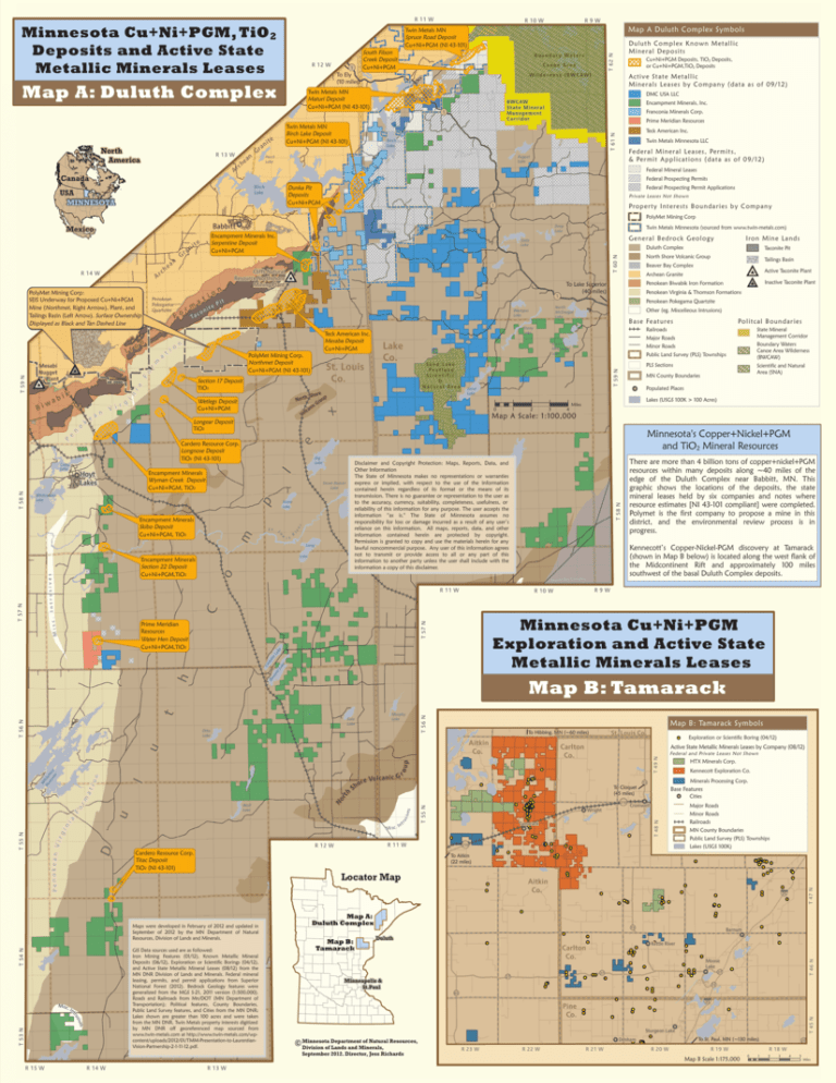
Minnesota Cu+Ni+PGM, TiO2 Deposits and Active State
advertisement

R 12 W Map A: Duluth Complex R 13 W A Canada h rc e an USA MINNESOTA Prime Meridian Resources Birch Lake Teck American Inc. Twin Metals Minnesota LLC Fe d e r a l M i n e r a l L e a s e s , Pe r m i t s , & Pe r m i t A p p l i c a t i o n s ( d a ta a s o f 0 9 / 1 2 ) August Lake Perch Lake Federal Mineral Leases Federal Prospecting Permits Dunka Dunka Pit Pit Deposits Deposits Cu+Ni+PGM Cu+Ni+PGM Federal Prospecting Permit Applications Private Leases Not Shown Pro p e r ty I nt e r e s ts B o u n da r i e s b y C o m p a n y 1 n B a s e Fe a t u r e s x er Minor Roads Public Land Survey (PLS) Townships PLS Sections 2 3 4 MN County Boundaries Populated Places Lakes (USGS 100K > 100 Acres) Miles Minnesota's Copper+Nickel+PGM and TiO2 Mineral Resources i s R Long Lake Kennecott’s Copper-Nickel-PGM discovery at Tamarack (shown in Map B below) is located along the west flank of the Midcontinent Rift and approximately 100 miles southwest of the basal Duluth Complex deposits. Beaver Bay Complex ak e Ca do tte La ke T 57 N Minnesota Cu+Ni+PGM Exploration and Active State Metallic Minerals Leases se tt L Map B: Tamarack t Ba s h R9W R 10 W C Prime Meridian Resources Water Hen Deposit Cu+Ni+PGM,TiO2 There are more than 4 billion tons of copper+nickel+PGM resources within many deposits along ~40 miles of the edge of the Duluth Complex near Babbitt, MN. This graphic shows the locations of the deposits, the state mineral leases held by six companies and notes where resource estimates [NI 43-101 compliant] were completed. Polymet is the first company to propose a mine in this district, and the environmental review process is in progress. T 56 N Murphy Lake Salo Lake Otto Lake Map B: Tamarack Symbols To Hibbing, MN (~60 miles) ro T 54 N T 53 N es siv ru R 14 W T 55 N HTX Minerals Corp. Kennecott Exploration Co. Minerals Processing Corp. 73 Base Features Cities Major Roads Cromwell T 48 N s s ive ru u Cardero Resource Corp. Titac Deposit TiO2 (NI 43-101) nt Federal and Private Leases Not Shown Wright Tamarack R 11 W R 12 W 210 To Aitkin (22 miles) Locator Map GIS Data sources used are as followed: Iron Mining Features (01/12), Known Metallic Mineral Deposits (06/12), Exploration or Scientific Borings (04/12), and Active State Metallic Mineral Leases (08/12) from the MN DNR Division of Lands and Minerals. Federal mineral leasing, permits, and permit applications from Superior National Forest (2012). Bedrock Geology features were generalized from the MGS S-21, 2011 version (1:500,000). Roads and Railroads from Mn/DOT (MN Department of Transportation); Political features, County Boundaries, Public Land Survey features, and Cities from the MN DNR; Lakes shown are greater than 100 acres and were taken from the MN DNR. Twin Metals property interests digitized by MN DNR off georeferenced map sourced from www.twin-metals.com at http://www.twin-metals.com/wpcontent/uploads/2012/01/TMM-Presentation-to-LaurentianVision-Partnership-2-1-11-12.pdf. Misc. Int To Cloquet (45 miles) 210 Mi sc. I D Pe n o ke a n V i rg in ia T 55 N Vo lc a ni c G e r o No rm rt at l io n W Re hite s e fa rv ce oi r Fo Wolf Lake Maps were developed in February of 2012 and updated in September of 2012 by the MN Department of Natural Resources, Division of Lands and Minerals. R 15 W h Sh Exploration or Scientific Boring (04/12) Active State Metallic Minerals Leases by Company (08/12) Carlton Co. up u Aitkin Co. St. Louis Co. R 13 W MN County Boundaries Public Land Survey (PLS) Townships Lakes (USGS 100K) Aitkin Co. 35 Map A: Duluth Complex Map B: Tamarack Minor Roads Railroads 73 Duluth Barnum Kettle River Carlton Co. Moose Lake 27 27 Minneapolis & St.Paul T 47 N u Scientific and Natural Area (SNA) T 46 N St. L o State Mineral Management Corridor Boundary Waters Canoe Area Wilderness (BWCAW) Major Roads e l p m Stone Lake Po l i tc a l B o u n d a r i e s Railroads o Intrusiv es 1 R 11 W . Misc Other (eg. Miscelleous Intrusions) Disclaimer and Copyright Protection: Maps, Reports, Data, and Other Information The State of Minnesota makes no representations or warranties express or implied, with respect to the use of the information contained herein regardless of its format or the means of its transmission. There is no guarantee or representation to the user as to the accuracy, currency, suitability, completeness, usefulness, or reliability of this information for any purpose. The user accepts the information “as is." The State of Minnesota assumes no Round responsibility for loss or damage incurred as a result of any user’s Lake reliance on this information. All maps, reports, data, and other information contained herein are protected by copyright. Permission is granted to copy and use the materials herein for any lawfulPine noncommercial purpose. Any user of this information agrees Laketransmit or provide access to all or any part of this not to information to another party unless the user shall include with the information a copy of this disclaimer. Seven Beaver Lake Whitewater Lake T 56 N Penokean Pokegama Quartzite Map A Scale: 1:100,000 Big Lake Encampment Minerals Wyman Creek Deposit Cu+Ni+PGM, TiO2 Encampment Minerals Section 22 Deposit Cu+Ni+PGM,TiO2 Penokean Virginia & Thomson Formations Sand Lake 0 iv P Cardero Resource Corp. Longnose Deposit TiO2 (NI 43-101) Encampment Minerals Skibo Deposit Cu+Ni+PGM, TiO2 Sand Lake Pe a t l a n d Scientific & Natural Area Inactive Taconite Plant Penokean Biwabik Iron Formation To Lake Superior (40 miles) South McDougal Lake ore h Sh p t r o N ou r G nic a lc Vo Longear Deposit TiO2 e n a e St. Louis Co. Active Taconite Plant Archean Granite 27 73 65 35 Pine Co. Sturgeon Lake Minnesota Department of Natural Resources, Division of Lands and Minerals, September 2012. Director, Jess Richards Denham R 23 W R 22 W R 21 W R 20 W T 45 N r o ia F Section 17 Deposit TiO2 PolyMet Mining Corp. Northmet Deposit Cu+Ni+PGM (NI 43-101) Tailings Basin Beaver Bay Complex Stony Lake Lake Co. Taconite Pit North Shore Volcanic Group North McDougal Lake Wampus Lake m a 1 Teck American Inc. Mesaba Deposit Cu+Ni+PGM I ro n M i n e L a nd s Duluth Complex Cliffs Natural Resource Northshore Mining Plant m nite r o F o Ta c o ti Ge n e r a l B e d ro c k G e o l o gy Slate Lake T 49 N Penokean Pokegama Quartzite n o i t a Pit Twin Metals Minnesota (sourced from www.twin-metals.com) Deep Lake Wetlegs Deposit Cu+Ni+PGM Hoyt Lakes T 58 N Franconia Minerals Corp. T 58 N e n r g i V Colby Lake T 57 N 1 T 60 N h rc an a Gr n k n Encampment Minerals, Inc. B W C AW State Mineral Management Corridor Encampment Minerals Inc. Serpentine Deposit Cu+Ni+PGM ite i T 59 N Mesabi Nugget Plant k Ac ti v e S t a t e M e t a l l i c Mi ne r a ls L e a s e s b y C o m pa n y ( da t a a s o f 0 9 / 1 2 ) T 59 N A n o Ir o Cu+Ni+PGM Deposits, TiO2 Deposits, or Cu+Ni+PGM,TiO2 Deposits DMC USA LLC Babbitt PolyMet Mining Mining:Corp: SEIS Underway for Proposed Cu+Ni+PGM Mine (Northmet, Right Arrrow), Plant, and Tailings Basin (Left Arrow). Surface Ownership Displayed as Black and Tan Dashed Line B Canoe Area Wilderness (BWCAW) Twin Metals MN Birch Lake Deposit Cu+Ni+PGM (NI 43-101) te D u lu t h Co m p l ex K n o w n M e t a l l i c Mi ne r a l D e p o s i ts PolyMet Mining Corp R 14 W iw Boundary Waters Twin Metals MN Maturi Deposit Cu+Ni+PGM (NI 43-101) Birch Lake Mexico i ab Gr To Ely (10 miles) Map A Duluth Complex Symbols T 61 N North America i an 1 Twin Metals MN Spruce Road Deposit Cu+Ni+PGM (NI 43-101) South Filson Creek Deposit Cu+Ni+PGM R9W R 10 W T 62 N Minnesota Cu+Ni+PGM, TiO 2 Deposits and Active State Metallic Minerals Leases R 11 W To St. Paul, MN (~130 miles) R 19 W Map B Scale 1:175,000 23 R 18 W 0 1 2 3 4 5 Miles


