Airborne Ladar Imaging Research Testbed
advertisement
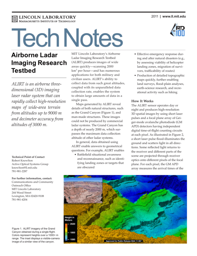
2011 | www.ll.mit.edu Tech Notes Airborne Ladar Imaging Research Testbed ALIRT is an airborne threedimensional (3D) imaging laser radar system that can rapidly collect high-resolution maps of wide-area terrain from altitudes up to 9000 m and decimeter accuracy from altitudes of 3000 m. Technical Point of Contact Robert Knowlton Active Optical Systems Group knowlton@ll.mit.edu 781-981-2287 For further information, contact: Communications and Community Outreach Office MIT Lincoln Laboratory 244 Wood Street Lexington, MA 02420-9108 781-981-4204 Figure 1. ALIRT imagery of the Grand Canyon obtained during a single flight. Colors represent heights over a 1000+ m range. The inset displays a visible-camera image of a similar view of the canyon. MIT Lincoln Laboratory’s Airborne Ladar Imaging Research Testbed (ALIRT) produces images of wide areas quickly—scanning 2000 km2 per hour—and has numerous applications for both military and civilian users. ALIRT’s ability to collect data from such great altitudes, coupled with its unparalleled data collection rate, enables the system to obtain large amounts of data in a single pass. Maps generated by ALIRT reveal details of both natural structures, such as the Grand Canyon (Figure 1), and man-made structures. These images could not be produced by commercial ladar systems. The Grand Canyon has a depth of nearly 2000 m, which surpasses the maximum data collection altitude of other ladar systems. In general, data obtained using ALIRT enable answers to geometrical questions. For example, ALIRT enables •Battlefield situational awareness and reconnaissance, such as identifying landing zones or targets that are obscured •Effective emergency response during and after natural disasters (e.g., by assessing viability of helicopter landing zones, migration of survivors, trafficability of routes) •Production of detailed topographic maps quickly, further enabling land surveys, flood-plain analyses, earth-science research, and recreational activity such as hiking How It Works The ALIRT sensor operates day or night and produces high-resolution 3D spatial images by using short laser pulses and a focal plane array of Geiger-mode avalanche photodiode (GM APD) detectors having independent digital time-of-flight counting circuits at each pixel. As illustrated in Figure 2, a short laser pulse flood-illuminates the ground and scatters light in all directions. Some reflected light returns to the receiver and different parts of the scene are projected through receiver optics onto different pixels of the focal plane. For each pixel, the GM APD array measures the arrival times of the returning pulses, which have distinct path lengths and thus arrive at different times. The time of flight of the light pulse to and from the target, relative to the outgoing laser pulse, encodes the range to the surface that scatters the light. The APD array of timers produces a range image instead of an intensity image typically produced by a camera. To accurately place this 3D range image into world space, the location and orientation of the receiver are supplied by a global positioning system/ inertial measurement unit (GPS/IMU). A scanning mirror rapidly moves the telescope field of view across the larger scene so that wide-area images can be generated. Straightforward trigonometry uses these inputs to create a geolocated 3D point-cloud image. Lincoln Laboratory has been developing high-resolution ladar sensors and technology since the 1970s. The Laboratory’s advances in compact solid-state microchip lasers and high-efficiency GM APD arrays have enabled compact, rugged ladar sensor systems. Lincoln Laboratory also developed the electronic subsystems used to read out the GM APD data at 160 MB/s and to record the raw data along with sensor and platform state data onto disks. Onboard operator interfaces are provided to control and monitor the sensor state, laser operations, and data acqui- Figure 2. A system block diagram provides an overview of ALIRT. sition and recording. A 64-core Linux cluster is used to perform low-latency onboard data processing. ALIRT Imagery Assists DisasterRelief Effort Principal applications of ALIRT were demonstrated in January 2010, during post-earthquake operations in Haiti. Over a period of 30 days, 49 flights collected ALIRT data to produce 30 cm digital surface models over the majority of the earthquake-impacted city of Portau-Prince. The United States Southern Command response to the earthquake consisted of providing resources, removing debris, establishing settlements, and creating infrastructure and resources for international relief agencies. ALIRT imagery assisted with many specific relief and recovery objectives: •Finding helicopter landing zones •Assessing road and bridge trafficability (Figure 3) •Effectively distributing food and water based on changes in refugee camp occupation inferred from volumetric change detection •Helping select locations for temporary housing using flood-plain analysis •Supporting longer-term infrastructure development projects ALIRT’s collection efficiency translates to faster results and reduced mission costs. ALIRT’s ability to generate imagery on board and send preliminary products to first responders with just a 20-minute latency is extremely effective in time-critical situations, such as emergency response. Additional Reading [1] R.M. Marino and W.R. Davis, Jr., “Jigsaw: A Foliage-Penetrating Imaging Laser Radar System,” Lincoln Laboratory Journal, vol. 15, no. 1, pp. 23–36, 2005. Figure 3. In Haiti, ALIRT’s direct and precise measurement of height and slope helped inform which type of vehicles may navigate obstructions. The inset depicts a section across the Rue de la Reunion in which the peak debris height is 2 m above the street surface. This work is sponsored by the Department of the Air Force under Air Force contract FA872105-C-0002. Opinions, interpretations, conclusions and recommendations are those of the author and are not necessarily endorsed by the United States Government.


