No. 33 Summer 2013 Urban Heat Island Effect Enhancement
advertisement

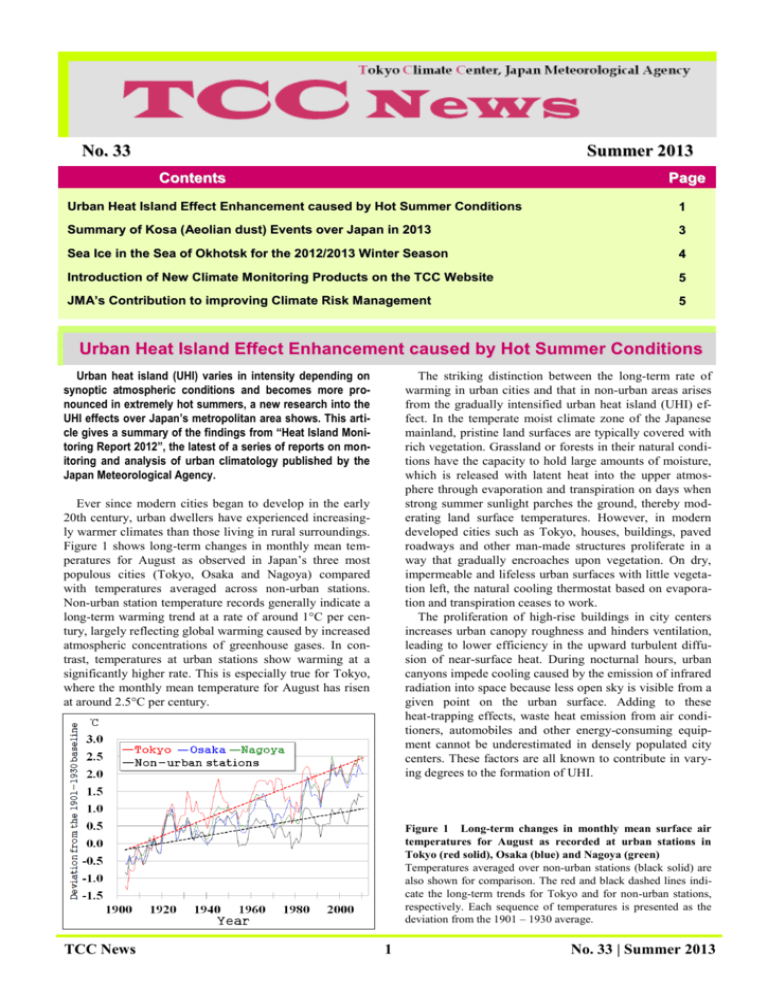
No. 33 Summer 2013 Contents Page Urban Heat Island Effect Enhancement caused by Hot Summer Conditions 1 Summary of Kosa (Aeolian dust) Events over Japan in 2013 3 Sea Ice in the Sea of Okhotsk for the 2012/2013 Winter Season 4 Introduction of New Climate Monitoring Products on the TCC Website 5 JM A’s Contribution to improving Climate Risk Management 5 Urban Heat Island Effect Enhancement caused by Hot Summer Conditions Urban heat island (UHI) varies in intensity depending on synoptic atmospheric conditions and becomes more pronounced in extremely hot summers, a new research into the UHI effects over Japan’s metropolitan area shows. This article gives a summary of the findings from “Heat Island Monitoring Report 2012”, the latest of a series of reports on monitoring and analysis of urban climatology published by the Japan Meteorological Agency. The striking distinction between the long-term rate of warming in urban cities and that in non-urban areas arises from the gradually intensified urban heat island (UHI) effect. In the temperate moist climate zone of the Japanese mainland, pristine land surfaces are typically covered with rich vegetation. Grassland or forests in their natural conditions have the capacity to hold large amounts of moisture, which is released with latent heat into the upper atmosphere through evaporation and transpiration on days when strong summer sunlight parches the ground, thereby moderating land surface temperatures. However, in modern developed cities such as Tokyo, houses, buildings, paved roadways and other man-made structures proliferate in a way that gradually encroaches upon vegetation. On dry, impermeable and lifeless urban surfaces with little vegetation left, the natural cooling thermostat based on evaporation and transpiration ceases to work. The proliferation of high-rise buildings in city centers increases urban canopy roughness and hinders ventilation, leading to lower efficiency in the upward turbulent diffusion of near-surface heat. During nocturnal hours, urban canyons impede cooling caused by the emission of infrared radiation into space because less open sky is visible from a given point on the urban surface. Adding to these heat-trapping effects, waste heat emission from air conditioners, automobiles and other energy-consuming equipment cannot be underestimated in densely populated city centers. These factors are all known to contribute in varying degrees to the formation of UHI. Ever since modern cities began to develop in the early 20th century, urban dwellers have experienced increasingly warmer climates than those living in rural surroundings. Figure 1 shows long-term changes in monthly mean temperatures for August as observed in Japan’s three most populous cities (Tokyo, Osaka and Nagoya) compared with temperatures averaged across non-urban stations. Non-urban station temperature records generally indicate a long-term warming trend at a rate of around 1°C per century, largely reflecting global warming caused by increased atmospheric concentrations of greenhouse gases. In contrast, temperatures at urban stations show warming at a significantly higher rate. This is especially true for Tokyo, where the monthly mean temperature for August has risen at around 2.5°C per century. Figure 1 Long-term changes in monthly mean surface air temperatures for August as recorded at urban stations in Tokyo (red solid), Osaka (blue) and Nagoya (green) Temperatures averaged over non-urban stations (black solid) are also shown for comparison. The red and black dashed lines indicate the long-term trends for Tokyo and for non-urban stations, respectively. Each sequence of temperatures is presented as the deviation from the 1901 – 1930 average. TCC News 1 No. 33 | Summer 2013 across the region. Extremely hot summer conditions in Japan are closely associated with the intensity, extent and persistency of the Northwestern Pacific High. In summers when this high-pressure system dominantly influences the eastern part of Japan, daylight hours are longer, southerly winds prevail and temperatures soar. These synoptic weather conditions also happen to be factors that contribute to the evolution of UHI intensity in the Kanto region. The longer-than-normal sunshine duration leads to greater diurnal heat uptake into the urban canopy. Southerly winds blowing from the sea, which is relatively cool and helps to dissipate heat accumulated across regions, weaken before reaching areas inland due to the presence of metropolitan areas on the coast of Tokyo Bay. These research results suggest that the UHI effect in the Kanto region acts like a type of positive feedback, exacerbating scorching heat in summers when synoptic atmospheric circulation patterns cause extremely high temperatures. For more details, a full report is available on the JMA website at http://www.data.kishou.go.jp/climate/cpdinfo/himr/2013/in dex.html (in Japanese). The effects of UHI, which in general gradually build in intensity and extent over decades as cities develop, may manifest themselves in different degrees depending on individual years’ weather conditions on meso- to synoptic scales, including sunshine duration and dominant wind velocity. This raises the question of how much UHI has affected urban temperatures in the summers of past years. To address this issue, the JMA Urban Climate Model (UCM) was run to reproduce observed temperatures under actual urban ground conditions as well as to illustrate how the climate might have been under hypothetical pristine ground conditions before mankind started to build cities. Comparison between the results of these two simulations provides a clear picture of annual variability in UHI intensity. The observed monthly mean temperatures were the highest on record since the end of the 19th century for August 2010 at all seven meteorological observatories across the Kanto Plain, and were the second highest for August 2012 at the four inland observatories. Figure 2 shows the spatial distribution of UHI intensity over the Kanto Plain defined as differences in monthly mean temperature between the simulations carried out under urban ground conditions and hypothetical pristine ground conditions for August 2009, 2010, 2011 and 2012. In the extremely hot summers of 2010 and 2012, the effects of UHI were significantly enhanced both in intensity and in extent (Yoshinori Oikawa, Climate Prediction Division) Figure 2 Spatial distribution of UHI intensity over the Kanto Plain for August 2009 (a), 2010 (b), 2011 (c) and 2012 (d) UHI intensity is defined as differences in monthly mean temperature between simulations with urban ground conditions and pristine ground conditions. TCC News 2 No. 33 | Summer 2013 Summary of Kosa (Aeolian dust) Events over Japan in 2013 Characteristics of Kosa events in 2013 From January to June 2013, the number of days on which meteorological stations in Japan observed Kosa (referred to below simply as the number of days) was 13, which was below the 1981 – 2010 normal of 23.1. The number of days was lower than the normal after April, while it was higher in January and March (Figure 3, left). The total number of stations observing Kosa (referred to here simply as the total number of stations) over the same period was 130, which was also below the normal of 208.3. The total number of stations was also much lower than the normal after April, while it was twice as high as the normal in March (Figure 3, right). Figure 3 Monthly number of days when meteorological stations in Japan observed Kosa (left), and the monthly total number of stations observing Kosa (right) from January to June 2013 The red and yellow bars show the values for 2013 and the 1981 – 2010 normals, respectively. Significant Kosa event in early March Kosa was observed at many stations in western and eastern Japan from 8 to 10 March (Figure 4). A large dust storm arose around the Ocher Plateau from 6 to 7 March. Massive volumes of dust particles were blown up into the atmosphere and carried over to Japan by upper-air westerly winds. The Kosa moved over Japan as low-pressure systems passed over the country from 8 to 10 March (Figure 5). Based on results from JMA’s Kosa prediction model, the Kosa was expected to move across the East China Sea and prevail over western Japan on 9 March (Figure 6). Using this forecast and surface observation reports from meteorological stations in Japan, JMA released information on the Kosa event to the public in order to call attention to potential traffic hazards due to visibility degradation on 9 March. Figure 4 Meteorological stations observing Kosa and minimum visibility on 9 March (Nozomu Ohkawara, Atmospheric Environment Division) Figure 5 Surface weather analysis charts at 09 JST (00 UTC) from 8 to 10 March Figure 6 Forecasts of surface dust concentration and surface wind by JMA’s Kosa prediction model at 09 JST (00 UTC) from 8 to 10 March (initial time: 21 JST (12 UTC) on 7 March) The Kosa was expected to reach western Japan on 8 March and prevail over western Japan the following day. TCC News 3 No. 33 | Summer 2013 Sea Ice in the Sea of Okhotsk for the 2012/2013 Winter Season The sea ice extent in the Sea of Okhotsk was near or less than normal from December 2012 to April 2013, and greater than normal in May 2013. The sea ice extent in the Sea of Okhotsk was near or less than normal from December 2012 to April 2013, and became greater than normal due to slow melting of ice in May (Figure 7). It reached its seasonal maximum of 107.13 x 10⁴ km2 (less than the normal of 116.92 x 10⁴ km2) on 15 March (Figures 7 and 8). Figure 9 shows overall trends for the period from 1971 to 2013. Although the sea ice extent in the Sea of Okhotsk shows large interannual variations, there is a long-term downward trend of 175 [71 – 279] x 104 km2 per decade (the numbers in square brackets indicate the two-sided 95% confidence interval) in the accumulated sea ice extent, and another long-term downward trend of 5.8 [2.2 – 9.5] x 104 km2 (equivalent to 3.7% of the area of the Sea of Okhotsk) per decade in the maximum extent. (Ryohei Okada, Office of Marine Prediction) Figure 7 Seasonal variation of sea ice extent at five-day intervals in the Sea of Okhotsk from November 2012 to July 2013 Figure 9 Interannual variations in the maximum sea ice extent (red line) and the accumulated sea ice extent (blue line) in the Sea of Okhotsk from 1971 to 2013 Accumulated sea ice extent: the sum of all five-day sea ice extent values from December to May Figure 8 Sea ice situation on 15 March 2013 The white area shows the observed sea ice extent, and the red line indicates the extent of normal coverage (1981 – 2010). TCC News 4 No. 33 | Summer 2013 Introduction of New Climate Monitoring Products on the TCC Website In July 2013, TCC started providing new climate monitoring products called Regional Maps on its website. These resources enable users to easily monitor the regional distribution of 10-day and half-monthly mean temperatures and total precipitation in Africa, Asia, South America, North America, Oceania and Europe. Regional Maps are produced using data from SYNOP messages received via GTS from WMO Members around the world, and represent 10-day or half-monthly mean temperatures, total precipitation amounts and their anomalies from the normal. In addition, time-series graphs of mean temperatures and total precipitation are available for stations selected by JMA (see Figures 10 and 11 as examples). The 10-day maps are updated on the 1st, 11th and 21st of the month, and the half-monthly maps are updated on the 1st and 16th of the month. These maps are available on the World Climate page of the TCC website at http://ds.data.jma.go.jp/tcc/tcc/products/climate/rmap/rmap .php. Figure 10 Ten-day mean temperatures in Asia from 1 to 10 July 2013 Figure 11 Time-series of ten-day total precipitation in Beijing, China from April to July 2013 (Hiroaki Minematsu, Tokyo Climate Center) JMA’s Contribution to improving Climate Risk Management Introduction Daily life and economic activity are greatly affected by anomalous climatic conditions. The potential for adverse effects from such conditions is referred to as climate risk, and climate risk management (CRM) involves understanding and taking effective measures against it. The Global Framework for Climate Services (GFCS) aims to enable better management of climate-related risks. To promote improved use of climate information in CRM in Japan, JMA has launched a dedicated website at http://www.data.jma.go.jp/gmd/risk/index.html (in Japanese). based on dialogue. Secondly, it is necessary to assess climate risk quantitatively by analyzing climate-related data and industrial data on variables such as agricultural production and sales. To this end, JMA provides an accessible and user-friendly climate database on the website to facilitate assessment of climate risk. Finally, climate-affected sectors can reduce adverse influences and increase benefits by taking action for adaptation to climate risk using various climate forecast products on the site. In addition to the current provision of the latest forecast products for adaptation, JMA also plans to output hindcast products enabling users to perform verification of their practical actions. New website to assist CRM The new website provides the following content to support approaches to CRM in Japan: • Clarification of the basic CRM concept and the related process • Information on good practices in CRM conducted by JMA together with partner organizations • Historical data (observations and statistics) and prediction data to support CRM The CRM process involves the steps of awareness, assessment and adaptation. JMA provides public- and private-sector operators with extensive support for and advice on better management of climate risk for each step. Firstly, it is necessary for each sector to be individually aware of the influence of the climate. In this context, JMA works to develop awareness of climate risks in various user sectors Good practices in CRM JMA has developed four good practices in CRM in collaboration with its partners. Good practices in CRM for the agriculture, health, energy and retail sectors are outlined on the website. TCC News Poster presented at IBCS-1 JMA presented a poster (see next page) introducing the new website supporting CRM in Japan to publicize its activities in relation to GFCS on a national level at the first session of the Intergovernmental Board on Climate Services (IBCS) and the Dialogue on “Operational Climate Services: Dialogue on Practical Action” held in Geneva, Switzerland from 1 to 5 July 2013. (Akira Itoh, Climate Prediction Division) 5 No. 33 | Summer 2013 Tokyo Climate Center (TCC), Climate Prediction Division, JMA Address: 1-3-4 Otemachi, Chiyoda-ku, Tokyo 100-8122, Japan TCC Website: http://ds.data.jma.go.jp/tcc/tcc/index.html Any comments or inquiry on this newsletter and/or the TCC website would be much appreciated. Please e-mail to tcc@met.kishou.go.jp. (Editors: Teruko Manabe, Ryuji Yamada and Kenji Yoshida) TCC News 6 No. 33 | Summer 2013


