Class B Airspace
advertisement
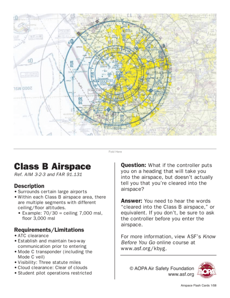
Fold Here Class B Airspace Ref. AIM 3-2-3 and FAR 91.131 Description • Surrounds certain large airports • Within each Class B airspace area, there are multiple segments with different ceiling/floor altitudes. • Example: 70/30 = ceiling 7,000 msl, floor 3,000 msl Question: What if the controller puts you on a heading that will take you into the airspace, but doesn’t actually tell you that you’re cleared into the airspace? Answer: You need to hear the words “cleared into the Class B airspace,” or equivalent. If you don’t, be sure to ask the controller before you enter the airspace. Requirements/Limitations • ATC clearance • Establish and maintain two-way communication prior to entering • Mode C transponder (including the Mode C veil) • Visibility: Three statute miles • Cloud clearance: Clear of clouds • Student pilot operations restricted For more information, view ASF’s Know Before You Go online course at www.asf.org/kbyg. © AOPA Air Safety Foundation www.asf.org Airspace Flash Cards 1/08 Fold Here Mode C Veil Ref: AIM 3-2-3 Description • Mode C veils exist within 30 nm of most Class B airports. (A list of these airports is available in FAR 91, Appendix D, Section 1) • Some Class B airspaces extend beyond the Mode C veil Requirements/Limitations • Mode C transponder • Certain exemptions apply. Refer to FAR 91.215 Question: My airport is based within a Mode C veil. If my transponder fails while outside the veil, can I get back in? Answer: When flying into a Mode C veil area with an inoperative transponder, the pilot needs to telephone the appropriate ATC facility having jurisdiction over the concerned airspace and request permission at any time to make the flight. Upon agreeing to conditions (including direction of flight and altitude), the pilot will be given a code number that he or she will mention to the controller upon initial radio contact. © AOPA Air Safety Foundation www.asf.org Airspace Flash Cards 1/08 Fold Here VFR Transition Routes Question: How do I ask ATC permission if I want to use a VFR transition route? Ref. AIM 3-5-5 Answer: On initial contact, you'll want Description • Used by ATC to route VFR traffic through Class B airspace • Depicted on terminal area charts Requirements/Limitations • ATC clearance • Mode C transponder • Adherence to published route and ATC instructions to notify ATC of your position, altitude, desired route name, and direction of flight. For more information, view ASF’s Know Before You Go online course at www.asf.org/kbyg. © AOPA Air Safety Foundation www.asf.org Airspace Flash Cards 1/08 Fold Here VFR Flyways Ref. AIM 3-5-5 Description • A general flight path that helps pilots plan flights into, out of, through, or near complex terminal airspace to avoid Class B airspace • ATC clearance not required Requirements/Limitations • Mode C transponder • Pilot must still comply with requirements for other airspace entered • Depicted on the back of terminal area charts Question: Will a VFR flyway take you into Class B airspace? Answer: No. VFR flyways are general paths used by pilots flying into, out of, through, or near terminal airspace to avoid Class B airspace. Remember, though, that they may take you through other areas with their own requirements (Class D airspace, for example). For more information, view ASF’s Know Before You Go online course at www.asf.org/kbyg. © AOPA Air Safety Foundation www.asf.org Airspace Flash Cards 1/08 Fold Here IFR Routes Ref: NACO Chart User’s Guide Description • Only depicted on VFR terminal area charts • Shows arrival and departure routes and altitudes of IFR traffic into and out of the terminal area of Class B airspace Requirements/Limitations • Not applicable Question: I’m a VFR pilot, so why do I need to know about IFR routes? Answer: The IFR routes depicted on the VFR terminal area charts should alert VFR pilots operating in terminal areas of arriving or departing IFR traffic. Maintain extra vigilance when flying through or near these routes. For more information, view ASF’s Know Before You Go online course at www.asf.org/kbyg. © AOPA Air Safety Foundation www.asf.org Airspace Flash Cards 1/08 Fold Here Class C Airspace Ref. AIM 3-2-4 and FAR 91.130 Description • Surrounds certain medium-sized airports • Typically 20 nm in diameter • Generally includes two segments with different floor/ceiling altitudes • Usually extends to 4,000 agl Requirements/Limitations • Establish and maintain two-way communication prior to entering • Mode C transponder • Visibility: Three statute miles • Cloud clearance: • 500 feet below • 1,000 feet above • 2,000 feet horizontal Question: You’re departing from a small nontowered field three miles from the primary airport in Class C airspace. Are you required to contact ATC prior to takeoff? Answer: Follow any procedures specified in the Airport/Facility Directory: In many cases, you may be able to contact ATC from the ground. Generally, however, you are only required to contact ATC as soon as practical after departure. © AOPA Air Safety Foundation www.asf.org Airspace Flash Cards 1/08 Fold Here Class D Airspace Ref. AIM 3-2-5 and FAR 91.129 Description • Surrounds smaller towered airports • Typically 10 nm in diameter • Ceiling generally 2,500 agl • Usually reverts to a Class E surface area when the tower is closed • May include Class E surface area extensions Question: Is there a speed limit within Class D airspace? Answer: Yes. Below 2,500 agl and within four nautical miles of the primary airport, aircraft are limited to 200 knots indicated airspeed. For more information, view ASF’s Know Before You Go online course at www.asf.org/kbyg. Requirements/Limitations • Establish and maintain two-way communication • Visibility: Three statute miles • Cloud clearance: • 500 feet below • 1,000 feet above • 2,000 feet horizontal © AOPA Air Safety Foundation www.asf.org Airspace Flash Cards 1/08 Fold Here Terminal Radar Service Area (TRSA) Question: Where do TRSAs fit in the national airspace classification system? Ref. AIM 3-5-6 and 4-1-17 Answer: TRSAs are “leftovers” from Description • Surrounds Class D airports with expanded ATC radar services Requirements/Limitations • Transponder and two-way communication for participating aircraft • Pilots not required to participate • Rules for Class D airspace within apply regardless of pilot participation with TRSA radar services the previous (pre-1993) airspace classification system. As a general rule, they exist at airports where traffic load requires enhanced radar service, but that aren’t busy enough to justify Class C airspace. For more information, view ASF’s Know Before You Go online course at www.asf.org/kbyg. © AOPA Air Safety Foundation www.asf.org Airspace Flash Cards 1/08 Fold Here Class E Airspace, Transition Area (700 agl) Ref. AIM 3-2-6(e)(3) Description • Surrounds many nontowered airports • Extends Class E airspace downward to accommodate IFR arrivals Question: What is the purpose of a Class E transition area? Answer: Class E transition areas exist to help traffic transition to or from the terminal or en route environment. For more information, view ASF’s Know Before You Go online course at www.asf.org/kbyg. Requirements/Limitations Below 10,000 msl: • Visibility: Three statute miles • Cloud clearance: • 500 feet below • 1,000 feet above • 2,000 feet horizontal © AOPA Air Safety Foundation www.asf.org Airspace Flash Cards 1/08 Fold Here Class E Airspace, Surface Area Question: What determines whether the airspace around an airport may be designated a Class E Surface Area? Ref. AIM 3-2-6(e)(1) and FAR 91.127 Answer: The airport must have either Description • Around some airports, Class E airspace begins at the surface, rather than the normal 700 or 1,200 agl • Class D airports with part-time towers usually become Class E surface areas when the tower is not in operation a weather observer or a functional automated weather observing system (AWOS or ASOS). For more information, view ASF’s Know Before You Go online course at www.asf.org/kbyg. Requirements/Limitations Below 10,000 msl: • Visibility: Three statute miles • Cloud clearance: • 500 feet below • 1,000 feet above • 2,000 feet horizontal © AOPA Air Safety Foundation www.asf.org Airspace Flash Cards 1/08 Fold Here Differentiates Floors of Class E Airspace Question: Where am I likely to encounter differences in Class E airspace depicted by this symbol? Ref: NACO Chart User’s Guide Answer: Typically in areas of high Description • Differentiates floors of airspace greater than 700 feet above the surface • When the ceiling is less than 18,000 msl, the value, prefixed by the word “ceiling,” will be shown along the limits of the airspace boundaries terrain, like the Grand Canyon, for example, and off the east and west coasts of the United States. For more information, view ASF’s Know Before You Go online course at www.asf.org/kbyg. Requirements/Limitations • Not Applicable © AOPA Air Safety Foundation www.asf.org Airspace Flash Cards 1/08 Fold Here Special Conservation Area Question: Is it legal to operate below 2,000 agl within a Special Conservation Area? Ref. AIM Chapter 7, Section 4 Answer: Yes, but pilots are requested Description • Surrounds many national parks, wildlife refuges, etc. to maintain a minimum altitude of 2,000 agl whenever possible. This can also help pilots avoid bird strikes at low altitudes. Requirements/Limitations • Pilots requested to avoid flight below 2,000 agl in these areas For more information, view ASF’s Know Before You Go online course at www.asf.org/kbyg. © AOPA Air Safety Foundation www.asf.org Airspace Flash Cards 1/08 Fold Here Prohibited Area Ref. AIM 3-4-2 Description • Established for security reasons • Example: Camp David (P-40) Requirements/Limitations • Flight within a Prohibited Area is not permitted Question: How much distance should I maintain from Prohibited Areas? Answer: It’s a good idea to steer well clear of Prohibited Areas. Allow at least a couple of miles to account for navigation error and variances between GPS and ATC radar positions. For more information, view ASF’s Know Before You Go online course at www.asf.org/kbyg. © AOPA Air Safety Foundation www.asf.org Airspace Flash Cards 1/08 Fold Here Restricted Area Ref. AIM 3-4-3 Description • Separates civilian traffic from potentially hazardous military activities Requirements/Limitations • Flight through an active Restricted Area is not permitted • Check with the controlling ATC facility (noted on sectional charts) for current status prior to entering Question: May you legally fly through an inactive Restricted Area? Answer: Yes, but you should be certain to contact the controlling ATC facility for current status before entering the airspace. For more information, view ASF’s Know Before You Go online course at www.asf.org/kbyg. © AOPA Air Safety Foundation www.asf.org Airspace Flash Cards 1/08 Fold Here Alert Area Ref. AIM 3-4-6 Description • Established in areas with a high volume of pilot training or unusual type of aerial activity Requirements/Limitations Question: Do I need to contact ATC prior to entering an Alert Area? Answer: No. ATC contact/clearance is not required to enter an Alert Area. For more information, view ASF’s Know Before You Go online course at www.asf.org/kbyg. • Pilots advised to be particularly vigilant in scanning for traffic © AOPA Air Safety Foundation www.asf.org Airspace Flash Cards 1/08 Fold Here Warning Area Ref. AIM 3-4-4 Description • Extends outward from 3 nm off the coast • Warns pilots of potentially hazardous activities Requirements/Limitations • VFR flight through active Warning Areas is permitted, though not recommended Question: Are you required to contact ATC before entering a Warning Area? Answer: No, but it is a good idea to contact the controlling ATC facility for status information prior to entry. Active Warning Areas can be dangerous to general aviation aircraft. For more information, view ASF’s Know Before You Go online course at www.asf.org/kbyg. © AOPA Air Safety Foundation www.asf.org Airspace Flash Cards 1/08 Fold Here Military Training Routes (MTRs) training route? Ref: AIM 3-5-2 Answer: A military training route, or Description • MTRs prefixed with the letters ‘IR’ are for IFR flights • MTRs prefixed with the letters ‘VR’ are for VFR flights • MTRs with a letter suffix (i.e., A, B, etc.) denote an alternate route • MTRs with four numbers denote routes flown at 1,500 agl and below • MTRs with three numbers denote routes flown above 1,500 agl Question: What exactly is a military MTR, is used by the military for conducting low-altitude, high-speed flight training. Typically the routes above 1,500 agl are flown under IFR, and the routes below 1,500 are flown under VFR. Contact flight service for MTR activity that might affect your route of flight. For more information, view ASF’s Know Before You Go online course at www.asf.org/kbyg. Requirements/Limitations • Not Applicable © AOPA Air Safety Foundation www.asf.org Airspace Flash Cards 1/08 Fold Here Military Operations Area (MOA) operations take place within MOAs? Ref. AIM 3-4-5 Answer: High-speed flight, aerobatic Description maneuvers, and low-level flight can all be expected. In certain MOAs, “lights out” night training is also permitted. • Established to allow military training activities Requirements/Limitations • VFR pilots may fly through active MOAs, but are advised to exercise extreme caution • It’s a good idea to check with the controlling ATC facility (noted on sectional charts) for MOA status prior to entering an MOA Question: What kinds of military flight For more information, view ASF’s Know Before You Go online course at www.asf.org/kbyg. © AOPA Air Safety Foundation www.asf.org Airspace Flash Cards 1/08 Fold Here Special Flight Rules Area Ref. Part 91 Special Federal Aviation Regulations (SFAR) Description Question: What kinds of procedures exist for flying within SFAR areas? Answer: Procedures vary. In the Grand Canyon, for example, special transition routes and altitude rules apply. • Depicts airspace subject to special regulation • Example: Grand Canyon Requirements/Limitations • As specified by SFAR • For operating rules, refer to the chart legend or the SFAR section at the beginning of FAR Part 91 © AOPA Air Safety Foundation www.asf.org Airspace Flash Cards 1/08 Fold Here National Security Area (NSA) Question: Where might you expect to Ref. AIM 3-5-7 Answer: NSAs can be established Description where a need for greater security exists, but are most often seen around government/military installations. • Established around areas requiring special security precautions Requirements/Limitations • Pilots are requested to avoid flight below a specified altitude within the NSA • Flight may be temporarily restricted or prohibited by notam find an NSA? For more information, view ASF’s Know Before You Go online course at www.asf.org/kbyg. © AOPA Air Safety Foundation www.asf.org Airspace Flash Cards 1/08 Fold Here Washington, D.C. ADIZ (Air Defense Identification Zone) Ref. AIM Chapter 5, Section 6 Description Question: If you’re cleared to enter the Washington, D.C. ADIZ, do you also have permission to enter the Class B airspace within? • 30 nm radius of the DCA VOR/DME • Speed restriction ring 30 to 60 nm radius of the DCA VOR/DME • Surface up to 17,999 msl Answer: No. You need a specific Requirements/Limitations For more information, view ASF’s Know Before You Go online course at www.asf.org/kbyg. • Active IFR or D.C. ADIZ flight plan • ATC communication • Discrete transponder code: Avoid 1200 at all times! • Monitor 121.5 if able • 180 KIAS or less within 30 nm radius of the DCA VOR/DME, if able • 230 KIAS or less in the 30 to 60 nm speed restriction ring, if able • Refer to www.aopa.org/security for additional information clearance to enter the Class B airspace. © AOPA Air Safety Foundation www.asf.org Airspace Flash Cards 1/08 Fold Here Flight Restricted Zone (FRZ) Question: Is there any way to legally fly into the FRZ? Answer: Yes. Before flying into the Description • 13 -15 nm radius of Washington, D.C. • Surface up to 17,999 msl Requirements/Limitations • General aviation flights prohibited with limited exceptions • Refer to www.aopa.org/security for additional information FRZ, GA pilots must undergo a background check and follow special procedures. Refer to www.aopa.org/security for more information. For more information, view ASF’s Know Before You Go online course at www.asf.org/kbyg. © AOPA Air Safety Foundation www.asf.org Airspace Flash Cards 1/08 Fold Here Contiguous U.S. ADIZ Question: What is a DVFR flight Ref. AIM 5-6-1 plan, and why is one required for VFR aircraft that enter the Contiguous U.S. ADIZ? Description Answer: A normal VFR flight plan is (Air Defense Identification Zone) • Surrounds the nation’s eastern, southern, and western borders Requirements/Limitations • IFR or DVFR (Defense VFR) flight plan • Discrete transponder code • DVFR aircraft must make position reports prior to entering not transmitted to ATC: It exists for search-and-rescue purposes only. A DVFR (Defense VFR) flight plan is transmitted to ATC, letting controllers know that the aircraft will be approaching the ADIZ under VFR. © AOPA Air Safety Foundation www.asf.org Airspace Flash Cards 1/08 Fold Here Temporary Flight Restriction (TFR) prior to the establishment of a TFR? Ref. AIM 3-5-3 Answer: In many cases, TFRs are Description • Most TFRs are not charted, although some longer-term TFRs are Requirements/Limitations • As specified by notam Question: How much notice is given established with little or no notice. Get a thorough Flight Service or DUATS briefing just prior to flight and call for updates when airborne. AOPA members can use the Real Time Flight Planner to plan routes around current and upcoming TFRs. Download the Real Time Flight Planner from AOPA’s Web site at www.aopa.org/flight_planner/intro.html. © AOPA Air Safety Foundation www.asf.org Airspace Flash Cards 1/08
