Management Plan (2010) Summary Document
advertisement
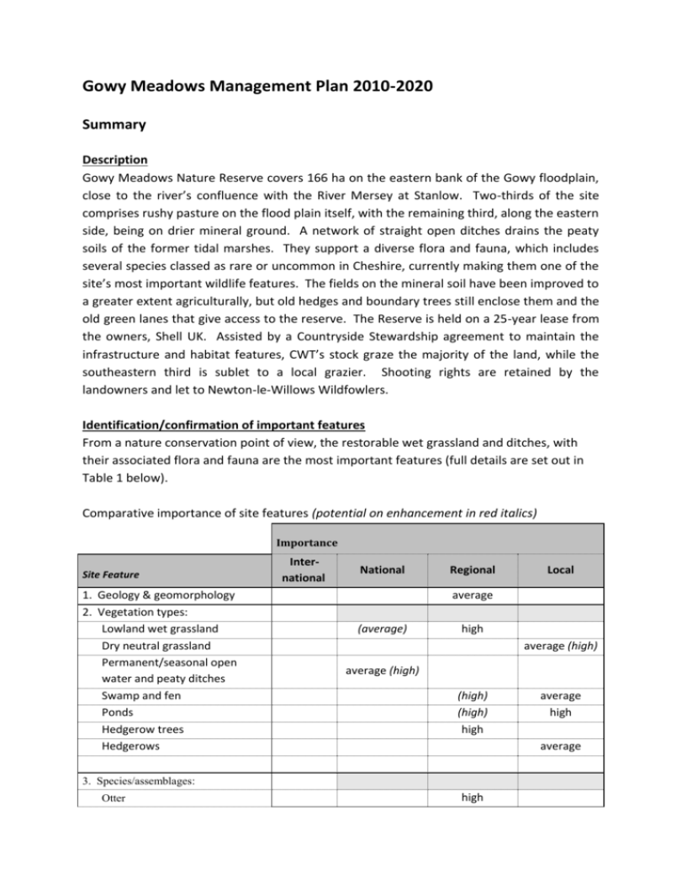
Gowy Meadows Management Plan 2010-2020 Summary Description Gowy Meadows Nature Reserve covers 166 ha on the eastern bank of the Gowy floodplain, close to the river’s confluence with the River Mersey at Stanlow. Two-thirds of the site comprises rushy pasture on the flood plain itself, with the remaining third, along the eastern side, being on drier mineral ground. A network of straight open ditches drains the peaty soils of the former tidal marshes. They support a diverse flora and fauna, which includes several species classed as rare or uncommon in Cheshire, currently making them one of the site’s most important wildlife features. The fields on the mineral soil have been improved to a greater extent agriculturally, but old hedges and boundary trees still enclose them and the old green lanes that give access to the reserve. The Reserve is held on a 25-year lease from the owners, Shell UK. Assisted by a Countryside Stewardship agreement to maintain the infrastructure and habitat features, CWT’s stock graze the majority of the land, while the southeastern third is sublet to a local grazier. Shooting rights are retained by the landowners and let to Newton-le-Willows Wildfowlers. Identification/confirmation of important features From a nature conservation point of view, the restorable wet grassland and ditches, with their associated flora and fauna are the most important features (full details are set out in Table 1 below). Comparative importance of site features (potential on enhancement in red italics) Importance Site Feature 1. Geology & geomorphology 2. Vegetation types: Lowland wet grassland Dry neutral grassland Permanent/seasonal open water and peaty ditches Swamp and fen Ponds Hedgerow trees Hedgerows International National Regional average (average) high average (high) average (high) (high) (high) high average high average 3. Species/assemblages: Otter Local high high Water Vole average (high) Great Crested Newt Wildfowl & waders (esp. Pintail, Lapwing, Snipe and Redshank*) Raptors (esp. Kestrel, Barn Owl, Hobby and Peregrine) Raptors (esp. Hen Harrier, Marsh Harrier and Short-eared Owl) Reed Bunting & Stonechat (breeding) ‘Farmland’ birds (sparrows, finches, buntings &c.) (high) average high (average) high low (high) Aquatic invertebrate assemblage Dragonfly/damselfly assemblage Wall (butterfly) high average (high) average high high Mud Snail Lesser Silver Water Beetle high Black Poplar high Bladderwort average high high average Brown Sedge Meadow Rue Whorl-grass Water-violet Rationalisation of Ideal Management Objectives Ideal Objective (abbreviated) Constraint Operational Objective/prescription Preserve/enhance the open character of the floodplain, creating conditions suitable for the long-term development of a vegetation mosaic typical of peaty, lowland grassland. Preserve, enhance and increase the ditches and seasonally flooded areas, especially Phragmites reedbed, associated with the floodplain grassland zone. Preserve/enhance previously agriculturally improved dry neutral grassland, managing land by traditional grazing and/or haymaking to encourage the development of a more typical community type. Water level control (TMD). Water for stock. Vehicle access for topping. Water level control. Safe poaching by stock. Potential pollution (TMD). Limited water quality data. Cost, if not funded. Legacy of elevated soil nutrient levels. As ‘Ideal’, but prescriptions need to accommodate constraints. As ‘Ideal’, but prescriptions need to accommodate constraints. As ‘Ideal’, but land may require remedial soil nutrient stripping. Safeguard, maintain and enhance appropriate habitat within those parts of the site that key fauna species are already known to use. Safeguard, maintain and enhance appropriate habitat within those parts of the site where key plants are already found. Enhance wet and dry grassland to provide breeding/over-wintering habitat attractive to Lapwing and a variety of wildfowl and wading birds. Preserve, enhance and increase pond and hedgerow features associated with the dry grassland zone. Maintain conditions to support avian predators and enhance wetland grassland to bring additional characteristic raptors. Prescribe and carry out an effective, low intensity monitoring strategy to enable the effectiveness of the management strategies to be assessed, and to provide useful data to assess unexpected habitat or species change attributable to off-site influences. Maintain an infrastructure allowing access for maintenance, monitoring and controlled public access across the site Increase public awareness and appreciation of the wildlife value of habitats associated with lowland wet grassland and traditionally managed farmland Improve wildlife links that connect Gowy Meadows Reserve to other wet grassland in the River Gowy floodplain and the nearby ‘Mersey’ Marshes Conflicting requirements of different species with overlapping distributions. Enhancement only when not adversely affecting other species of interest. Conflicting requirements of different species with overlapping distributions. As for fauna (above), but there is less likelihood of conflict. Tussocky nature of sward. No tilled land. Concentrate effort on areas where there will be least public disturbance. Cost, if not funded. GCN presence, otherwise none. Adverse impact on Water Voles, Waterfowl and Waders. As ‘Ideal’, but ensure a Pond Conservation Licence is in place. Enhance habitats to increase capacity. Cost, if not funded. Insufficient experts to undertake the work. Very important, but constraints impose stringent limitations on scope. Essential to adopt a ‘SMART’ monitoring strategy. H & S (terms of lease). No infrastructure (styles, paths and bridges). Objective should be for only limited increase. Limited public access on site, otherwise none. Use the site to promote sensitive floodplain management via ‘The Grebe’ and other media. Landfill site sterilises a part. Highway fragmentation. Stanlow refinery. CWT is not the landowner. Use opportunities arising from ‘Mersey and Gowy Washlands Project’. Offer grazing if stock available. Existing/Desired States and the prescribed management required to realise the plan objectives are portrayed in map format. The key maps are: Map H - Existing State; Map J - Desired; State; Map K - Management Required.
