Joint spatial development program in Brandenburg, Germany
advertisement

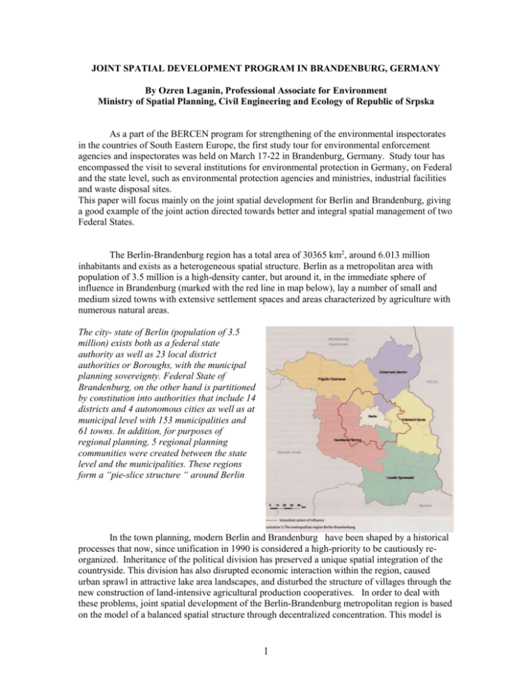
JOINT SPATIAL DEVELOPMENT PROGRAM IN BRANDENBURG, GERMANY By Ozren Laganin, Professional Associate for Environment Ministry of Spatial Planning, Civil Engineering and Ecology of Republic of Srpska As a part of the BERCEN program for strengthening of the environmental inspectorates in the countries of South Eastern Europe, the first study tour for environmental enforcement agencies and inspectorates was held on March 17-22 in Brandenburg, Germany. Study tour has encompassed the visit to several institutions for environmental protection in Germany, on Federal and the state level, such as environmental protection agencies and ministries, industrial facilities and waste disposal sites. This paper will focus mainly on the joint spatial development for Berlin and Brandenburg, giving a good example of the joint action directed towards better and integral spatial management of two Federal States. The Berlin-Brandenburg region has a total area of 30365 km2, around 6.013 million inhabitants and exists as a heterogeneous spatial structure. Berlin as a metropolitan area with population of 3.5 million is a high-density canter, but around it, in the immediate sphere of influence in Brandenburg (marked with the red line in map below), lay a number of small and medium sized towns with extensive settlement spaces and areas characterized by agriculture with numerous natural areas. The city- state of Berlin (population of 3.5 million) exists both as a federal state authority as well as 23 local district authorities or Boroughs, with the municipal planning sovereignty. Federal State of Brandenburg, on the other hand is partitioned by constitution into authorities that include 14 districts and 4 autonomous cities as well as at municipal level with 153 municipalities and 61 towns. In addition, for purposes of regional planning, 5 regional planning communities were created between the state level and the municipalities. These regions form a “pie-slice structure “ around Berlin In the town planning, modern Berlin and Brandenburg have been shaped by a historical processes that now, since unification in 1990 is considered a high-priority to be cautiously reorganized. Inheritance of the political division has preserved a unique spatial integration of the countryside. This division has also disrupted economic interaction within the region, caused urban sprawl in attractive lake area landscapes, and disturbed the structure of villages through the new construction of land-intensive agricultural production cooperatives. In order to deal with these problems, joint spatial development of the Berlin-Brandenburg metropolitan region is based on the model of a balanced spatial structure through decentralized concentration. This model is 1 comprised of a policy of settlement development that aims to limit sub-urbanisation by decentralized concentration in central towns, following previous development patterns along rail connections. The number of inhabitants and work places continues to grow in the immediate sphere of influence while in Berlin the number of inhabitants and work places decreases, which will not be balanced through a population influx from other parts of the federal region. Within the immediate sphere of influence these developments are considered as dangerous in that the clearly defined settlement structure with their open spaces will be destroyed and the unique existence of natural regeneration areas with their associated relaxation qualities are threatened. The peripheral regions of the State of Brandenburg contain, on the other hand, the thinnest populated areas of the Federal German Republic. In these areas it has been noted that since 1990 there has been a severe drop in the offers of work places, especially in the industrial sector, as well as an intense population decrease following migration in the Berlin surroundings as well as an acute drop in the birth rate. In the meantime, these areas are classified as underdeveloped. In February 1992, the decision was taken between the states of Berlin and Brandenburg over the implementation of the Joint Spatial Development Programme (LEPro) and the Joint Spatial Development Plan for the immediate sphere of influence (LEPeV). When the regional planning treaty between Berlin and Nrandenburg came into effect on the 1st January 1995, the formation of the Joint Spatial Development Department (GL) was agreed and started their work on the 1st January 1996. The objective of the GL is to provide plans for the development of the joint planning space of Berlin-Brandenburg which transcendent departments and supra regional and integrated. The GL looks after those tasks of spatial and regional planning of the Berlin Senate Department for Urban Development as well as the Brandenburg Ministry for Agriculture, Environmental Protection and Spatial Planning. The final target is a balanced use of development potentials and distribution of the development possibilities. The protection and preservation of the natural resources in accordance with the Principle of “sustainability”, or in other words development of a joint economic, political, and cultural future, shall contribute to this goal in that the joint planning space effectively exist within the competition of the European regions. The binding basis for the regional planning and development in Berlin and Brandenburg are the Joint Spatial Development Program (LEPro and the Joint Spatial Development plans (LEP) which evolved from this program and from which the development targets for functionality or spatially partial areas will be established. Achievement of the goals of sustainability, and in particular of the ecological part of the sustainable development concept is incorporated strongly in the development plan of Berlin and Brandenburg. After the unification, importance was placed on the preservation of the available open space as areas for leisure, relaxation, and nature conservation and for economic reasons. Located between the railway orientated settlement areas, regional parks compliment the “green fingers” that penetrate into the urban landscape of Berlin in the for of a belt of parks located around the suburban areas that comprise open spaces for recreation as well as controlled development locations in the surroundings. For the medium and long-term period, it is foreseen the creation of eight regional parks with a total area of 2000 sq. km in the Berlin’s perimeter and nearby surroundings. Finally it can be stated that the researches have shown that since 1990 the requirements for primary energy, emissions of the greenhouse gasses and requirements for potable water and waste generation in the metropolitan region of Berlin-Brandenburg have declined. However, still 2 existing problem is growing traffic and land use. Therefore, the GL has developed a model for regional and suburban development, as shown in the chart below: Managing supply and demand of land, in accordance with the regional development strategy is supposed to be placed within the framework of regional area management through strengthening central place functions, and therefore detailed concepts and management instruments are to be defined for sub elements of urban development. The decisions of the GL relating to Regional Policy Harmonization Procedure for large projects and the co-ordination of the local development planning to the targets and tasks of the spatial and regional planning have a legally binding character and have a lasting effect on the choice of location for infrastructure provision and the land use on a municipal level. 3


