Grade 6 - Farmington River Regional School District
advertisement
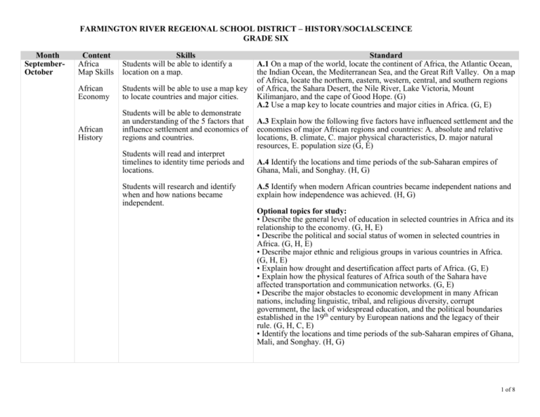
FARMINGTON RIVER REGEIONAL SCHOOL DISTRICT – HISTORY/SOCIALSCEINCE GRADE SIX Month SeptemberOctober Content Africa Map Skills Skills Students will be able to identify a location on a map. African Economy Students will be able to use a map key to locate countries and major cities. African History Students will be able to demonstrate an understanding of the 5 factors that influence settlement and economics of regions and countries. Standard A.1 On a map of the world, locate the continent of Africa, the Atlantic Ocean, the Indian Ocean, the Mediterranean Sea, and the Great Rift Valley. On a map of Africa, locate the northern, eastern, western, central, and southern regions of Africa, the Sahara Desert, the Nile River, Lake Victoria, Mount Kilimanjaro, and the cape of Good Hope. (G) A.2 Use a map key to locate countries and major cities in Africa. (G, E) A.3 Explain how the following five factors have influenced settlement and the economies of major African regions and countries: A. absolute and relative locations, B. climate, C. major physical characteristics, D. major natural resources, E. population size (G, E) Students will read and interpret timelines to identity time periods and locations. A.4 Identify the locations and time periods of the sub-Saharan empires of Ghana, Mali, and Songhay. (H, G) Students will research and identify when and how nations became independent. A.5 Identify when modern African countries became independent nations and explain how independence was achieved. (H, G) Optional topics for study: • Describe the general level of education in selected countries in Africa and its relationship to the economy. (G, H, E) • Describe the political and social status of women in selected countries in Africa. (G, H, E) • Describe major ethnic and religious groups in various countries in Africa. (G, H, E) • Explain how drought and desertification affect parts of Africa. (G, E) • Explain how the physical features of Africa south of the Sahara have affected transportation and communication networks. (G, E) • Describe the major obstacles to economic development in many African nations, including linguistic, tribal, and religious diversity, corrupt government, the lack of widespread education, and the political boundaries established in the 19th century by European nations and the legacy of their rule. (G, H, C, E) • Identify the locations and time periods of the sub-Saharan empires of Ghana, Mali, and Songhay. (H, G) 1 of 8 FARMINGTON RIVER REGEIONAL SCHOOL DISTRICT – HISTORY/SOCIALSCEINCE GRADE SIX Month NovemberJanuary Content Western Asia Map Skills Western Asia Economy Skills Students will be able to identify a location on a map. Students will be able to use a map key to locate countries and major cities. Standard WA.1 On a map of the world, locate Western Asia, or the Middle East. On a map of the Middle East, locate the Black Sea, Mediterranean Sea, Caspian Sea, Red Sea, Indian Ocean, Arabian Peninsula, and the Persian Gulf. (G) WA.2 Use a map key to locate countries and major cities in the Middle East. (G, E) Students will be able to demonstrate an understanding of the 5 factors that influence settlement and economics of regions and countries. WA.3 Explain how the following five factors have influenced settlement and the economies of major Middle Eastern countries: A. absolute and relative locations, B. climate, C. major physical characteristics, D. major natural resources, E. population size (G, E) Students will read and interpret Western timelines to identity time periods and Asia History locations. Students will research and identify when and how nations became independent. WA.4 Locate and describe the various ethnic and religious groups of the Middle East. (G, H, C, E) WA.5 Identify when the countries in the Middle East became independent nations and explain how independence was achieved. (H, G) Optional topics for study: • Describe the general level of education in selected countries in Western Asia and its relationship to the economy. (G, H, E) • Describe the political and social status of women in selected countries in Western Asia. (G, H, E) • Describe major ethnic and religious groups in various countries in Western Asia. (G, H, E) • Compare the form and structure of government for Turkey, Saudi Arabia, Jordan, Iraq, Iran, and Israel. © • Identify the methods used to compensate for the scarcity of water in some areas. (E) • Identify where the Kurds live and what their political aspirations are. (H) • Discuss the reasons for and the effects of the United nations’ attempt in 1947 to partition the remainder of the Palestinian Mandate, including the migration of tens of thousands of European Jews to Palestine, the flight of about 650,000 Arabs from Israel during its War of Independence in 1948, and the flight of more than 800,000 Jews in Arab countries to Israel after 1948. (H, G) 2 of 8 Month Month FARMINGTON RIVER REGEIONAL SCHOOL DISTRICT – HISTORY/SOCIALSCEINCE GRADE SIX Content Skills Standard Content Skills Standard 3 of 8 FARMINGTON RIVER REGEIONAL SCHOOL DISTRICT – HISTORY/SOCIALSCEINCE GRADE SIX Month Content Skills Standard Central and Students will be able to identify a CSA.1 On a map of the world, locate Central and South Asia. On a map of South Asia location on a map. Central and South Asia, locate the Indian Ocean, the Arabian Sea, the Bay of Map Skills Bengal, the Ganges River, the Indo-Gangetic Plateau, the Northern Mountains, Students will be able to use a map key to the Deccan Plateau, the Himalayan Mountains, and the Steppes. (G) Central and locate countries and major cities. CSA.2 Use a map key to locate the countries and major cities in Central and South Asia South Asia. (G, E) Economy Students will be able to demonstrate an CSA.3 Explain how the following five factors have influenced settlement and understanding of the 5 factors that the economies of major Central and South Asian countries: A. absolute and influence settlement and economics of relative locations, B. climate, C. major physical characteristics, D. major Central And regions and countries. natural resources, E. population size (G, E) South Asia CSA.4 Identify when India, Pakistan, Bhutan, Nepal, Bangladesh, Sri Lanka, History Students will research and identify when and the central Asian republics first became independent countries and explain and how nations became independent. how independence was achieved. Explain the relationship of the Central Asian republics to the former Soviet Union. (H, G) Optional topics for study: • Explain the reasons for and the effects of the partition of the Indian subcontinent into India and Pakistan in 1947 and the exchange of more than 12 million Hindus and Muslims. (H, G, C) • Identify the historical factors that created a stable democratic government in India and the role of Mohandas Gandhi, Jawaharlal Nehru, and Indira Gandhi in its development. (H, C) • Explain why the Indian government seeks to control population growth and the methods it uses to control population growth. (H, G) • Describe the political, cultural, and religious differences between the countries in South Asia and the central Asian republics. (H, C, E) • Describe the general level of education in selected countries in Central and South Asia and its relationship to the economy. (G, H, E) • Describe the political and social status of women in selected countries in Central and South Asia. (G, H, E) • Describe major ethnic and religious groups in various countries in Central and South Asia. (G, H, E) • Locate the Khyber Pass in Afghanistan and explain its strategic importance as a gateway from the north into the Indian subcontinent. (H, G) 4 of 8 FARMINGTON RIVER REGEIONAL SCHOOL DISTRICT – HISTORY/SOCIALSCEINCE GRADE SIX Month Content Skills Standard Southeast Students will be able to identify a SEAO.1 On a map of the world, locate Southeast Asia, the Indian Ocean, Asia Map location on a map. Australia, New Zealand, Antarctica, the major Pacific islands, the Pacific Ocean, Skills and the Coral Sea. On a map of Southeast Asia and Oceania, locate the bay of Students will be able to use a map key Bengal, the South China Sea, the Great Victoria Desert, and the Great Barrier to locate countries and major cities. Reef. (G) Southeast Asia Students will be able to demonstrate an SEAO.2 Use a map key to locate countries and major cities in the various regions Economy understanding of the 5 factors that of Southeast Asia, Australia, and the major Pacific islands. (G, E) influence settlement and economics of regions and countries. SEAO.3 Explain how the following five factors have influenced settlement and Southeast the economies of major countries of Southeast Asia and Oceania: A. absolute and Asia History Students will research and identify relative locations, B. climate, C. major physical characteristics, D. major natural when and how nations became resources, E. population size (G, E) independent. SEAO.4 Identify when countries in Southeast Asia and Oceania became independent and describe how independence was achieved. (G, H) Optional topics for study: • Describe the general level of education in selected countries in Southeast Asia and Oceania and its relationship to the economy. (G, H, E) • Describe the political and social status of women in selected countries in Southeast Asia and Oceania. (G, H, E) • Describe major ethnic and religious groups in various countries in Southeast Asia and Oceania. (G, H, E) • Explain how levels of education and work traditions contributed to the postWorld War II growth of East Asian and Southeast Asian economies (e.g., South Korea, Japan, Taiwan, Hong Kong, and Singapore). (G, E) • Identify the refugees who left Southeast Asia over the past several decades, the countries they came from, and why they are refugees. (G, H) • Identify and describe the major social features of the indigenous peoples in Australia (the Aborigines) and New Zealand (the Maoris). (G, H) • Explain how Australia’s and New Zealand’s population size and location affect their capacity to engage in international trade. (G, E) Month Content Skills Standard 5 of 8 FARMINGTON RIVER REGEIONAL SCHOOL DISTRICT – HISTORY/SOCIALSCEINCE GRADE SIX Month Content Skills Standard North and Students will be able to identify a NEA.1 On a map of the world, locate North and east Asia, the Pacific Ocean, East Asia location on a map. and the Arctic Ocean. On a map of East Asia, locate the Sea of Japan, the Map Skills Yellow Sea, the East China Sea, the Gobi Desert, the Himalayas, and the Huang Students will be able to use a map key He (Yellow) and Chang Jiang (Yangtze) Rivers. On a map of North Asia, locate North and to locate countries and major cities. Siberia and the Yenisey, Lena, and Kolyma Rivers. (G) East Asia Economy Students will be able to demonstrate an NEA.2 Use a map key to locate the countries and major cities in the various understanding of the 5 factors that regions of east Asia. (G, E) influence settlement and economics of North and regions and countries. NEA.3 Explain how the following five factors have influenced settlement and East Asia the economies of major East Asian countries: A. absolute and relative locations, History Students will research and identify B. climate, C. major physical characteristics, D. major natural resources, E. when and how nations became population size (G, E) independent. NEA.4 Identify when Taiwan, North Korea, South Korea, and Mongolia became independent countries and describe how independence was achieved. (G, H) Optional topics for study: • Describe the general level of education in selected countries in East Asia and its relationship to the economy. (G, H, E) • Describe the political and social status of women in selected countries in East Asia. (G, H, E) • Describe major ethnic and religious groups in various countries in East Asia. (G, H, E) • Explain why China’s geographic boundaries served to limit it interactions with other regions and cultures for many centuries. (G, H) • Locate Tibet on a map and explain why its location may have influenced China’s decision to take over and colonize it. (G, H) • Explain how location has made the Korean peninsula both a battleground and a cultural bridge between China and Japan. (G, H) • Describe why the Chinese government seeks to control population growth and the methods it uses to control population growth. (G, H) • Describe and explain the status of Taiwan. (H, G) • Identify the number of time zones the Asiatic part of Russia spans, identify the routes used by Russian explorers, traders, and religious dissidents to cross into what is now Alaska. (H, G) 6 of 8 FARMINGTON RIVER REGEIONAL SCHOOL DISTRICT – HISTORY/SOCIALSCEINCE GRADE SIX Month FebruaryApril Content Europe Map Skills Skills Students will be able to identify a location on a map. Students will be able to use a map key to locate countries and major cities. Europe Economy Students will be able to demonstrate an understanding of the 5 factors that influence settlement and economics of regions and countries. Standard E.1 On a map of the world, locate the continent of Europe. On a map of Europe, locate the Atlantic Ocean, Arctic Ocean, Norwegian Sea, and Barents Sea. Locate the Volga, Danube, Ural, Rhine, Elbe, Seine, Po, and Thames Rivers. Locate the Alps, Pyrenees, and Balkan Mountains. Locate the countries in the northern, southern, central, eastern, and western regions of Europe. (G) E.2 Use a amp key to locate countries and major cities in Europe. (G) E.3 Explain how the following five factors have influenced settlement and the economies of major European countries: A. absolute and relative locations, B. climate, C. major physical characteristics, D. major natural resources, E. population size (G, E) Optional topics for study: • Describe the general level of education in selected countries in Europe and its relationship to the economy. (G, H, E) • Describe the political and social status of women in selected countries in Europe. (G, H, E) • Describe major ethnic and religious groups in various countries in Europe. (G, H, E) •Explain why Europe has a highly developed network of highways, waterways, railroads, and airline linkages. (G, H, E) • Describe the purposes and achievements of the European Union. (H, E) • Identify the countries that were once part of the Soviet Union in the Baltic area, Central Asia, Southern Russia, and the Caucuses, and compare the population and size of the former Soviet Union with that of present day Russia. (H, G) 7 of 8 FARMINGTON RIVER REGEIONAL SCHOOL DISTRICT – HISTORY/SOCIALSCEINCE GRADE SIX Month MayJune Content Skills South Students will be able to identify a location America Map on a map. Skills Students will be able to use a map key to locate countries and major cities. South America Students will be able to demonstrate an Economy understanding of the 5 factors that influence settlement and economics of regions and countries. South America Students will research and identify when History and how nations became independent. Standard SAM.1 On a map of the world, locate South America and the Atlantic and Pacific Oceans. On a map of South America, locate the Amazon, the Andes Mountains, Cape Horn, and the southern, northern, eastern, and western regions of South America. (G) SAM.2 Use a map key to locate the countries and major cities of South America. (G, E) SAM.3 Explain how the following five factors have influenced settlement and the economies of major South American countries: A. absolute and relative locations, B. climate, C. major physical characteristics, D. major natural resources, E. population size (G, E) SAM.4 Identify when South American countries became independent nations and explain how independence was achieved. (H, G). Optional topics for study: • Describe the general level of education in selected countries in South America and its relationship to the economy. (G, H, E) • Describe the political and social status of women in selected countries in South America. (G, H, E) • Describe major ethnic and religious groups in various countries in South America. (G, H, E) • Describe the major obstacles to economic development in may South American nations, including the political influence of the military, corrupt government, the lack of widespread education, and the absence of stable governments. (G, H, C, E) 8 of 8
