techtabl
advertisement
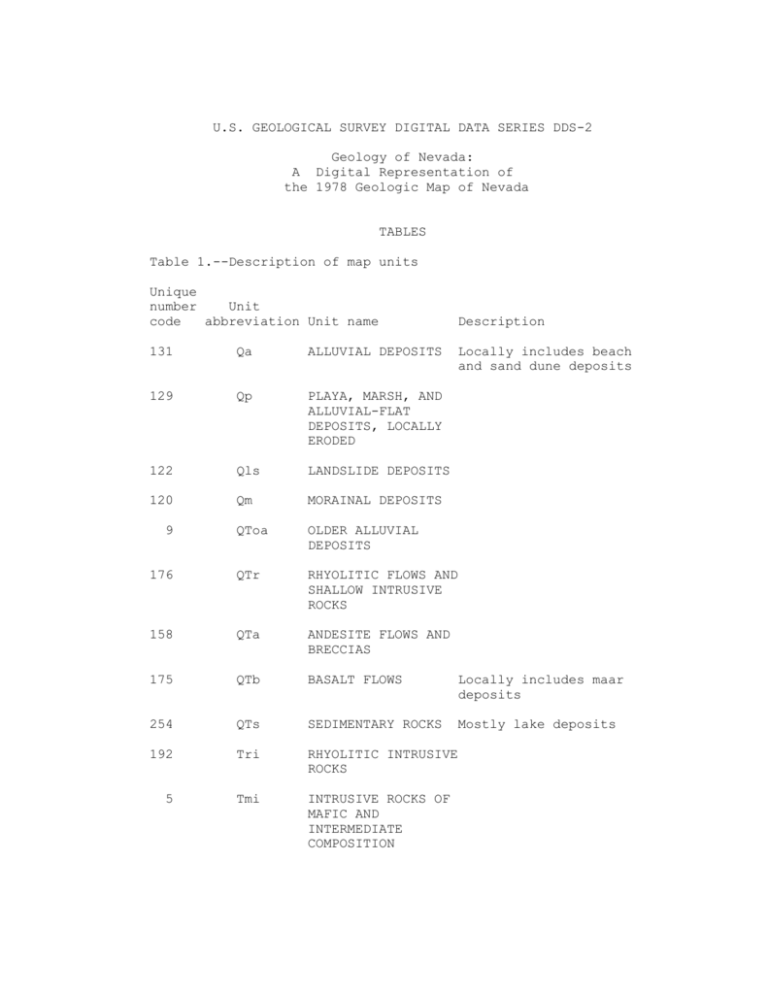
U.S. GEOLOGICAL SURVEY DIGITAL DATA SERIES DDS-2 Geology of Nevada: A Digital Representation of the 1978 Geologic Map of Nevada TABLES Table 1.--Description of map units Unique number Unit code abbreviation Unit name Description 131 Qa ALLUVIAL DEPOSITS 129 Qp PLAYA, MARSH, AND ALLUVIAL-FLAT DEPOSITS, LOCALLY ERODED 122 Qls LANDSLIDE DEPOSITS 120 Qm MORAINAL DEPOSITS QToa OLDER ALLUVIAL DEPOSITS 176 QTr RHYOLITIC FLOWS AND SHALLOW INTRUSIVE ROCKS 158 QTa ANDESITE FLOWS AND BRECCIAS 175 QTb BASALT FLOWS Locally includes maar deposits 254 QTs SEDIMENTARY ROCKS Mostly lake deposits 192 Tri RHYOLITIC INTRUSIVE ROCKS 5 Tmi INTRUSIVE ROCKS OF MAFIC AND INTERMEDIATE COMPOSITION 9 Locally includes beach and sand dune deposits 1 188 Ti INTRUSIVE ROCKS Aphanitic, porphyritic, and coarsely granular rocks ranging in composition from diorite to granite. Clark County 167 Tbr BRECCIA Volcanic, thrust, and jasperoid breccia and landslide megabreccia 187 Tt3 WELDED AND NONWELDED SILICIC ASH-FLOW TUFFS Locally includes thin units of air-fall and tuff and sedimentary rock 200 Trt ASH-FLOW TUFFS, RHYOLITIC FLOWS, AND SHALLOW INTRUSIVE ROCKS 182 Tr3 RHYOLITIC FLOWS AND SHALLOW INTRUSIVE ROCKS 164 Ta3 ANDESITE AND RELATED ROCKS OF INTERMEDIATE COMPOSITION Flows and breccias 173 Tba ANDESITE AND BASALT FLOWS Mostly in ~17 to ~6 m.y. age range. In Humboldt County, locally includes rocks as old as 21 m.y. May include rocks younger than 6 m.y. in places 107 Tb BASALT FLOWS 106 Tbg BANBURY FORMATION 154 Tts ASH-FLOW TUFFS AND TUFFACEOUS SEDIMENTARY ROCKS 139 Ts3 TUFFACEOUS SEDIMENTARY ROCKS Locally includes minor amounts of tuff 137 Ths HORSE SPRING Tuffaceous sedimentary Basalt, gravel, and tuffaceous sediments locally. Northeast Humboldt County and northwest Elko County FORMATION rocks, southern Nevada 2 100 TKsu CONTINENTAL SEDIMENTARY ROCKS Clark County 171 Tt2 WELDED AND NONWELDED SILICIC ASH-FLOW TUFFS Locally includes thin units of air-fall tuff and sedimentary rock 174 Tr2 RHYOLITIC FLOWS AND SHALLOW INTRUSIVE ROCKS 152 Ta2 ANDESITE AND RELATED ROCKS OF INTERMEDIATE COMPOSITION 133 Tob OLDER BASALT ROCKS 146 Ts2 TUFFACEOUS SEDIMENTARY ROCKS Locally includes minor amounts of tuff 189 Tt1 WELDED AND NONWELDED SILICIC ASH-FLOW TUFFS Locally includes thin units of air-fall tuff and sedimentary rocks 161 Tr1 RHYOLITIC FLOWS AND SHALLOW INTRUSIVE ROCKS 160 Ta1 ANDESITE AND RELATED ROCKS OF INTERMEDIATE COMPOSITION Flows and breccias 127 Ts1 SEDIMENTARY ROCKS Includes Sheep Pass Formation (Eocene) and related units and unnamed tuffaceous sedimentary rocks 140 TKs CONTINENTAL SEDIMENTARY ROCKS Includes units such as Pansy Lee Conglomerate in Humboldt County, part of Cretaceous(?) and Tertiary rocks of Kleinhampl and Ziony (1967) in northern Nye County, and part of "older clastic rocks" of Tschanz and Pampeyan (1970) in Lincoln County Flows and breccias 3 141 Ks CONTINENTAL DEPOSITS OF SILTSTONE, SHALE, CONGLOMERATE, AND LIMESTONE Includes units such as King Lear Formation in Humboldt County, Newark Canyon Formation in Eureka County, Willow Tank Formation and Baseline Sandstone in Clark County 157 TJgr GRANITIC ROCKS, CENTRAL AND EASTERN NEVADA Mostly quartz monzonite and granodiorite. Inconclusively dated or not dated radiometrically Tgr GRANITIC ROCKS Mostly quartz monzonite and granodiorite 184 Mzgr GRANITIC ROCKS, WESTERN NEVADA (Mesozoic) Mostly quartz monzonite and gradodiorite. Inconclusively dated or not dated radiometrically 249 Kgr GRANITIC ROCKS Mostly quartz monzonite and granodiorite 198 Kjd DIORITE 180 Jgr GRANITIC ROCKS Mostly quartz monzonite and granodiorite 241 Trgr GRANITIC ROCKS Quartz monzonite in northern Esmeralda County 165 KJim IGNEOUS AND METAMORPHIC COMPLEX Pegmatitic granite and other granitic rocks complexly intermixed with metasedimentary rocks. Considered to be Mesozoic igneous complex intruding lower Paleozoic and possibly Precambrian Z sedimentary rocks. Grades into units shown on map as lower Paleozoic. Ruby Mountains and East Humboldt Range, Elko County 11 4 145 JTrsv SHALE, SANDSTONE, VOLCANOGENIC CLASTIC ROCKS, ANDESITE, RHYOLITE, AND LOCALLY THICK CARBONATE UNITS Undivided sequence locally containing recognizable equivalents of the Luning and Dunlap Formations 76 Jd DUNLAP FORMATION (Lower and Middle Jurassic) Conglomerate, sandstone, greenstone, felsite, and tuff. Locally contemporaneous with folding and thrusting. Mineral County and adjacent parts of Esmeralda and Nye Counties 99 Jgb GABBROIC COMPLEX (Lower and Middle Jurassic) Includes gabbro, basalt, and synorogenic quartz sandstone (Boyer Ranch Formation). Churchill and Pershing Counties 83 Jv VOLCANIC SANDSTONE, FELSIC ASH-FLOW TUFFS, RHYOLITE, AND RHYODACITE FLOWS (Upper? Jurassic) Pony Trail Group of Cortez Mountains, Eureka County 77 JTrs SHALE, MUDSTONE, SILTSTONE, SANDSTONE, AND CARBONATE ROCK; SPARSE VOLCANIC ROCK (Upper Triassic and Lower Jurassic) Includes Auld Lang Syne Group, Nightingale sequence on Bonham (1969), and Gabbs and Sunrise Formations 78 Trc LIMESTONE, MINOR AMOUNTS OF DOLOMITE, SHALE, AND SANDSTONE; LOCALLY THICK CONGLOMERATE UNITS (Lower, Middle, and Upper Triassic) Includes Tobin, Dixie Valley, Favret, Augusta Mountain, and Cane Spring Formations and Star Peak Group in central Nevada and Grantsville and Luning Formations in west-central Nevada 5 87 Trk KOIPATO GROUP AND RELATED ROCKS (Lower Triassic) Altered andesitic flows, rhyolitic tuffs and flows, and clastic rocks. Includes rocks mapped by Silberling (1959) as Pablo Formation and originally considered to be Permian in the Shoshone Mountains, Nye County. Includes Tallman Fanglomerate (Permian?) in Humboldt County 92 Trlgr LEUCOGRANITE AND RHYOLITE PORPHYRY 251 JTra AZTEC SANDSTONE (Triassic? and Jurassic) Friable fine- to mediumgrained sandstone with conspicuous large-scale cross strata; considered eolian. Age based on correlation with Navajo Sandstone 79 Trch CHINLE FORMATION AND ASSOCIATED ROCKS (Upper Triassic) Continental deposits of variegated bentonitic claystone, siltstone, and clayey sandstone; ledgeforming sandstone; and red siltstone 250 siltstone, Trmt MOENKOPI Marine deposits of FORMATION, THAYNES limestone, and sparse conFORMATION, AND glomerate RELATED ROCKS (Lower Triassic) 85 110 80 JPu VOLCANOGENIC Age uncertain. Mineral, SEDIMENTARY ROCKS, Esmeralda, and northwest TUFF, ANDESITIC Nye Counties AND FELSITIC FLOWS, AND CARBONATE ROCKS TrPs SILTY LIMESTONE, MINOR AMOUNTS OF SHALE, AND SOME GREENSTONE TrPvs VOLCANIC FLOWS AND Includes Happy Creek FLOW BRECCIAS, Volcanic Series and related CHIEFLY OF rocks in Humboldt County Unnamed sequence in Adobe Range, northern Elko County ANDESITIC COMPOSITION, TUFFS, SPARSE SANDSTONE AND and similar rocks in Washoe and Pershing Counties; includes andesite breccias and volcanogenic GRAYWACKE rocks in Mineral County sedimentary 6 39 PMh HAVALLAH SEQUENCE OF SILBERLING AND ROBERTS (1962) Chert, argillite, shale, greenstone, and minor amounts of siltstone, sandstone, conglomerate, and limestone. Includes Schoonover Formation of Fagan (1962) and Reservation Hill Formation in Elko County, Farrel Canyon Formation in southwestern Humboldt County, Havallah and Pumpernickel Formations in Pershing, Lander, and parts of Humboldt Counties, and rocks originally considered a part of the Pablo and Excelsior Formations in northern Nye, northern Esmeralda, and southern Mineral Counties. Assignment of some rocks to the Havallah sequence in the East Range, Pershing County, is highly uncertain. Includes rocks ranging in age from Late Mississippian to Early Permian 36 Msv SILICEOUS AND In Humboldt County, VOLCANIC ROCKS of altered pillow lavas, coarse volcanic breccias, clastic limestone, and consists minor amounts of sandstone, shale, siliceous shale, and chert of the Goughs Canyon Formation (Lower and Upper Mississippian). In the East Range, Pershing County, consists of quartzite, conglomerate, slate, limestone, chert, and greenstone of the Inskip Formation (Mississippian?) 239 Mountains, Ml MASSIVE LIMESTONE In the San Antonio western Nye County 7 232 TrPd CONGLOMERATE, SANDSTONE, SHALE, AND DOLOMITE OF DIABLO FORMATION BELOW AND SHALE, SANDSTONE, AND CONGLOMERATE OF CANDELARIA FORMATION ABOVE (Lower or Upper Permian to Lower Triassic) Mineral, Esmeralda, and northwestern Nye Counties PPa ANTLER SEQUENCE OF SILBERLING AND ROBERTS (1962) (Middle Pennsylvanian to Early or Late Permian) (Guadalupian) Conglomerate, sandy to conglomeratic limestone, limestone, sandstone, and calcareous shale. Thin detrital and carbonate sequence within main part of Antler orogenic belt. Includes units such as Sunflower Formation of Bushnell (1967) in Elko County, Battle Formation, Antler Peak Limestone, and Edna Mountain Formation in Lander and western Eureka Counties, and Wildcat Peak Formation in northern Nye County 222 MDmc CONGLOMERATE, LIMESTONE, METAANDESITE, PHYLLITE, AND SHALE Includes Grossman, Banner, Nelson, and Mountain City Formations. Northern Elko County 238 PPcd SANDY AND SILTY LIMESTONE, CONGLOMERATE, AND SILTSTONE (Upper Pennsylvanian to Upper Permian) Includes units such as Strathearn Formation of Dott (1955) and Buckskin Mountain, Beacon Flat, and Carlin Canyon Formations of Fails (1960) in Elko County and Carbon Ridge and Garden Valley Formations in Eureka County Pcd LIMESTONE, CHERTY LIMESTONE, SANDY LIMESTONE, AND CHERT-PEBBLE CONGLOMERATE (Lower and Middle Includes units such as Moleen and Tomera Formations of Dott (1955) 50 62 Pennsylvanian) 8 179 MDs SHALE, SILTSTONE, SANDSTONE, CHERTPEBBLE CONGLOMERATE, AND LIMESTONE Includes units such as Pilot Shale, Joana Limestone, Chainman Shale, and Diamond Peak Formation in northern and eastern Nevada and Narrow Canyon Limestone, Mercury Limestone, and Eleana Formation in southern Pc CHERTY LIMESTONE AND SPARSE DOLOMITE, SHALE, Includes units such as Park City Group and equivalent rocks in AND SANDSTONE (Lower and Upper Permian) Nevada and Torowean Formation and Kaibab Limestone in southern Nevada 64 northern Nevada 221 PMc LIMESTONE, DOLOMITE, AND SHALE (Upper Paleozoic) Includes Van Duzer Limestone of Decker (1962) 225 Psc SILTSTONE, SANDSTONE, LIMESTONE AND DOLOMITE (COMMONLY SILTY OR SANDY), AND GYPSUM (Lower Permian) Includes units such as Rib Hill Sandstone and Pequop Formation of Steele (1959) in Elko County, Rib Hill Sandstone and Arcturus Formation in White Pine County, Queantoweap Sandstone of McNair (1951), Hermit Shale, and Coconino Sandstone in Clark and southern Lincoln Counties 235 PPc LIMESTONE AND SPARSE DOLOMITE, SILTSTONE, AND SANDSTONE (Lower Pennsylvanian to Lower Permian) Includes units such as undivided Riepe Spring Limestone of Steele (1960) and Ely Limestone or their equivalent in Elko, White Pine, and northern Lincoln Counties and most of the Bird Spring Formation and Callville Limestone in Clark and southern Lincoln Counties. Includes some stratigraphically higher Permian rocks in Leppy Peak, easternmost Elko County 60 Pc LIMESTONE Includes Ely Limestone (mostly Lower and Middle Pennsylvanian) 43 Mc LIMESTONE AND Includes units such as Rogers MINOR AMOUNTS OF Spring and Monte Cristo DOLOMITE AND SHALE Limestones 9 119 Pzsp SERPENTINITE (Paleozoic) Mineral, northwestern Nye, and eastern Humboldt 242 DCsv CHERT, SHALE, ARGILLITE, SILTSTONE, QUARTZITE, AND GREENSTONE Undivided siliceous assemblage. Mostly Ordovician 216 Dsl SLAVEN CHERT Chert and sparse limy sandstone, siltstone, and limestone. Lander County 237 Ds SHALE, SILICEOUS SILTSTONE, CHERT, AND MINOR AMOUNTS OF LIMESTONE Includes Cockalorum Wash Wash Formation on northern Nye County and Woodruff Formation and unnamed rocks in Elko County 236 Se ELDER SANDSTONE Feldspathic sandstone, siltstone, shale, and Counties chert. Lander County 178 Ss SHALE AND CHERT Includes Fourmile Canyon Formation in Eureka County and Noh Formation of Riva (1970) and unnamed rocks in Elko County 101 Osv SILICEOUS AND VOLCANIC ROCKS Chert, shale, quartzite, greenstone, and minor amounts of limestone. Includes units such as Valmy Formation of northcentral Nevada and some rocks mapped as Palmetto Formation in northern part of Esmeralda County and adjacent parts of Mineral and Nye Counties. Locally includes rocks of Silurian and Devonian age 109 Os SHALE, CHERT, AND MINOR AMOUNTS OF QUARTZITE, GREENSTONE, AND LIMESTONE Includes units such as Vinini Formation of northcentral Nevada, Palmetto Formation in southern and central parts of Esmeralda County, and Comus Formation in Humboldt County. Locally includes rocks of Silurian and Devonian age 10 116 Ch HARMONY FORMATION (Upper Cambrian) Feldspathic and arkosic sandstone and minor amounts of shale, limestone, and 114 Csc SCOTT CANYON Chert, shale, greenstone, FORMATION or Middle Cambrian) (Lower sparse limestone and quartzite. Southeast Humboldt County and chert and Northwest Lander County 71 Dt ARGILLACEOUS LIMESTONE, CHERT, AND SHALE Elko and Eureka Counties 13 St PLATY LIMESTONE AND LIMY SILTSTONE, CHERT AT BASE Includes units such as Roberts Mountains Formation, and Storff Formation and Chellis Limestone of Decker (1962). Locally includes rocks of Early Devonian age at top 204 Ot SHALE, CHERT, AND LIMESTONE Includes Aura Formation of Decker (1962) in northwest Elko County and Perkins Canyon Formation of Kay and Crawford (1964) in northern Nye County 253 OCt PHYLLITE, SHALE, AND LIMESTONE Locally includes chert and quartzite. Includes Tennessee Mountain Formation of Bushnell (1967) in western Elko County, Broad Canyon sequence of Means (1962) in Lander County, and rocks originally mapped as Palmetto Formation in Toiyabe and Toquima Ranges, northern Nye County 170 Ct SHALE AND THINIncludes units such as BEDDED OR Preble and Emigrant LAMINATED LIMEFormations STONE; ALSO THINLY INTERBEDDED LIME- STONE AND CHERT 231 CZs PHYLLITIC SILTSTONE, QUARTZITE, AND LESSER AMOUNTS OF LIMESTONE AND DOLOMITE 11 Includes Reed Dolomite; Deep Sprint, Campito, Poleta, Harkless, and Saline Valley Formations; and Mule Spring Limestone 113 Zw WYMAN FORMATION Phyllite and phyllitic siltstone and minor amounts of limestone, dolomite, and sandstone 41 Dc DOLOMITE, LIMESTONE, AND MINOR Includes units such as Sevy and Simonson AMOUNTS OF SANDSTONE AND QUARTZITE Guilmette and Nevada Formations, and Devils Gate Limestone Dolomites, 244 DCc DOLOMITE AND LIMESTONE (Lower Paleozoic 248 Sc DOLOMITE Includes units such as Laketown and Lone Mountain Dolomites. Locally includes rocks of Early Devonian age at top 17 SOc DOLOMITE Includes uppermost part of Ordovician System (Ely Springs Dolomite and equivalent rocks) and all of Silurian System 212 Oc LIMESTONE, DOLOMITE, SHALE, AND QUARTZITE Includes units such as Pogonip Group, Eureka Quartzite, and Ely Springs Dolomite. Where Ely Springs Dolomite or equivalent rocks are included in SOc unit, this unit includes only the Pogonip Group and Eureka Quartzite or their equivalents 233 OCc DOLOMITE AND LIMESTONE Undivided Cambrian and Ordovician rocks in part of Clark County; mostly Cambrian 247 Cc LIMESTONE AND DOLOMITE, LOCALLY Includes units such as Pioche Shale, Eldorado THICK SEQUENCES OF SHALE AND SILTSTONE Dolomite, Geddes Limestone Secret Canyon Shale, Hamburg Dolomite, Dunderberg Shale, and Windfall Formation of northern Nevada and Carrara, Bonanza King, and Nopah Formations of southern Nevada 12 255 CZq QUARTZITE AND MINOR AMOUNTS OF CONGLOMERATE, PHYLLITIC SILTSTONE, LIMESTONE, AND DOLOMITE Includes Prospect Mountain Quartzite, Osgood Mountain Quartzite, and Gold Hill Formation in northern Nevada and Stirling Quartzite, Wood Canyon Formation, and Zabriskie Quartzite in southern Css SANDSTONE AND QUARTZITE Includes Tapeats Sandstone and related rocks. Rests Nevada. 108 on Precambrian metamorphic rocks 115 Zqs QUARTZITE, PHYLLITIC SILTSTONE, CONGLOMERATE, LIMESTONE, Includes McCoy Creek Group (excluding Stella Lake Quartzite) of Misch and Hazzard (1962) in AND DOLOMITE central Nevada and Johnnie Formation in southern GRANITIC ROCKS Porphyritic rapakivi eastNevada 136 granite; Ygr 1,450 plus or minus 25 m.y. (L.T. Silver, oral commun., 1973) 3 Xm METAMORPHIC ROCKS Gneiss and schist and lesser amounts of gneissic granite, pyroxenite, hornblendite, migmatite, pegmatite, and marble. Includes highly folded granite lenses 1,740 plus or minus 25 m. y. old (L.T. Silver, oral commun., 1973). In southern Nye County, may be Precambrian Z rocks metamorphosed during the Mesozoic 13 Table 2.--Coverage files of Nevada contained on this CD-ROM EXPORT FILES Prime Pages* North coverage South coverage NVNLL NVSLL 3570 3535 DLG FILES North coverage NVNLLP1.DLG NVNLLP2.DLG NVNLLP3.DLG 1528 1405 1566 South coverage NVSLLP1.DLG NVSLLP2.DLG NVSLLP3.DLG 1755 1743 1439 ASCII FILES North coverage NVNLLP1.AAT NVNLLP1.PAT NVNLLP2.AAT NVNLLP2.PAT NVNLLP3.AAT NVNLLP3.PAT 474 116 476 118 389 93 South coverage NVSLLP1.AAT NVSLLP1.PAT NVSLLP2.AAT NVSLLP2.PAT NVSLLP3.AAT NVSLLP3.PAT 461 81 420 93 480 105 *1 Prime Page = 2048 Bytes 14 Table 3.--Unique numeric code used for color palette of legend 1 45 89 133 - Tob 178 - Ss 222 - 2 3 - Xm 4 46 47 48 90 91 92 - Trlgr 134 135 136 - Ygr 179 - MDs 180 - Jgr 181 223 224 225 - 5 - Tmi 6 7 8 9 - QToa 10 49 50 - PPa 51 52 53 54 93 94 95 96 97 98 137 138 139 140 141 142 182 - Tr3 183 184 - Mzgr 185 186 187 - Tt3 226 227 228 229 230 231 - 11 - Tgr 55 99 - Jgb 143 188 - Ti 232 - 12 56 100 - TKsu 145 - JTrsv 189 - Tt1 233 - 13 - St 14 57 58 101 - Osv 102 146 - Ts2 147 190 191 234 235 - 15 59 103 148 192 - Tri 236 - 16 60 - Pc 104 149 193 237 - 17 - SO 61 105 150 194 238 - 18 62 - Pcd 106 - Tbg 151 195 239 - 19 20 63 64 - Pc+ 107 - Tb 108 - Css 152 - Ta2 153 196 197 240 241 - 21 65 109 - Os 154 - Tts 198 - Kjd 242 - 22 23 66 67 110 - TrPs 111 155 156 199 200 - Trt 243 244 - 24 25 26 68 69 70 112 113 - Zw 114 - Csc 157 - TJgr 158 - QTa 159 201 202 203 245 246 247 - 27 71 - Dt 115 - Zqs 160 - Ta1 204 - Ot 248 - 28 72 116 - Ch 161 - Tr1 205 249 - 29 73 117 162 206 250 - 30 74 118 163 207 251 - 31 32 75 76 - Jd 119 - Pzsp 120 - Qm 164 - Ta3 165 - KJim 208 209 252 253 - MDmc Psc - Ths - Ts3 - TKs - Ks CZs TrPd OCc PPc Se Ds PPcd Ml Trgr DCsv DCc Cc Sc Kgr Trmt JTra OCt 33 77 - JTrs 121 166 210 254 - 34 78 - Trc 122 - Qls 167 - Tbr 211 255 - 168 169 170 171 172 173 174 175 176 177 212 - Oc 213 214 215 216 - Dsl 217 218 219 220 221 - PMc 256 QTs CZq 35 36 37 38 39 40 41 42 43 44 - Msv - PMh - Dc - Mc 79 80 81 82 83 84 85 86 87 88 - Trch 123 - TrPvs 124 125 126 - Jv 127 - Ts1 128 - JPu 129 - Qp 130 - Trk 131 - Qa 132 15 - Ct - Tt2 - Tba Tr2 QTb QTr Table 4.--Detailed descriptions of north and south ARC/INFO EXPORT coverages Arc: NORTH COVERAGE DESCRIBE NVNLL Description of SINGLE precision coverage NVNLL ARCS POLYGONS Arcs = 42693 Segments = 134681 40 bytes of Arc Attribute Data Polygons = 9308 Polygon Topology is present. 46 bytes of Polygon Attribute Data POINTS Label Points = SECONDARY FEATURES 9278 Tics Annotations Links TOLERANCES = = = 28 0 0 STATUS Fuzzy = 0.000 V The coverage has not been Dangle = 0.000 V since the last BUILD or CLEAN. Edited COVERAGE BOUNDARY Xmin Xmax = = -120.001 -113.999 Ymin Ymax = = 38.997 42.003 SOUTH COVERAGE Arc: DESCRIBE NVSLL DESCRIBE NVSLL OVER NVN DESCRIBE NVNLL Description of SINGLE precision coverage NVSLL ARCS POLYGONS Arcs = 42262 Segments = 179038 28 bytes of Arc Attribute Data Polygons = 11106 Polygon Topology is present. 34 bytes of Polygon Attribute Data POINTS Label Points = 11100 TOLERANCES SECONDARY FEATURES Tics Annotations Links STATUS = = = 23 0 0 Fuzzy = 0.000 V The coverage has not been Dangle = 0.000 V since the last BUILD or CLEAN. Edited 16 COVERAGE BOUNDARY Xmin Xmax = = -120.062 -114.000 Ymin Ymax = = 34.996 39.038 17 Table 5.--Detailed descriptions of six DLG-3 format files of Nevada Arc: DESCRIBE NVNLLP1 Description of SINGLE precision coverage NVNLLP1 ARCS Arcs = 14685 Segments = 46416 40 bytes of Arc Attribute Data Attribute Data POLYGONS Polygons = 2815 Polygon Topology is present. 46 bytes of Polygon POINTS Label Points = SECONDARY FEATURES 2815 Tics Annotations Links TOLERANCES = = = 28 0 0 STATUS Fuzzy = 0.000 V The coverage has not been Dangle = 0.000 V since the last BUILD or Edited CLEAN. COVERAGE BOUNDARY Xmin Xmax = = -120.000 -114.000 Arc: DESCRIBE NVNLLP2 Description of SINGLE precision coverage NVNLLP2 ARCS = = 41.000 42.000 POLYGONS Arcs = 13386 Segments = 42410 40 bytes of Arc Attribute Data Attribute Data POINTS Label Points = Ymin Ymax Polygons = 3179 Polygon Topology is present. 46 bytes of Polygon SECONDARY FEATURES 3189 TOLERANCES Tics Annotations Links = = = 28 0 0 STATUS Fuzzy = 0.000 V The coverage has not been Dangle = 0.000 V since the last BUILD or Edited CLEAN. COVERAGE BOUNDARY Xmin Xmax = = -120.000 -114.000 Ymin Ymax 18 = = 40.000 41.000 Arc: DESCRIBE NVNLLP3 Description of SINGLE precision coverage NVNLLP3 ARCS POLYGONS Arcs = 15179 Segments = 45679 40 bytes of Arc Attribute Data Attribute Data Polygons = 3592 Polygon Topology is present. 46 bytes of Polygon POINTS Label Points = SECONDARY FEATURES 3597 Tic Annotations Links TOLERANCES = = = 28 0 0 STATUS Fuzzy = 0.000 V The coverage has not been Dangle = 0.000 V since the last BUILD or Edited CLEAN. COVERAGE BOUNDARY Xmin Xmax = = -120.000 -114.000 Ymin Ymax Arc: DESCRIBE NVSLLP1 Description of SINGLE precision coverage NVSLLP1 ARCS 39.000 40.000 POLYGONS Arcs = 15104 Segments = 63943 28 bytes of Arc Attribute Data Attribute Data Polygons = 4017 Polygon Topology is present. 34 bytes of Polygon POINTS Label Points = = = SECONDARY FEATURES 4017 Tics Annotations Links TOLERANCES = = = 23 0 0 STATUS Fuzzy = 0.000 V The coverage has not been Dangle = 0.000 V since the last BUILD or Edited CLEAN. COVERAGE BOUNDARY Xmin Xmax = = -120.000 -114.000 Ymin Ymax 19 = = 38.000 39.001 Arc: DESCRIBE NVSLLP2 Description of SINGLE precision coverage NVSLLP2 ARCS POLYGONS Arcs = 14959 Segments = 63795 28 bytes of Arc Attribute Data Attribute Data Polygons = 4043 Polygon Topology is present. 34 bytes of Polygon POINTS Label Points = SECONDARY FEATURES 4043 Tics Annotations Links TOLERANCES = = = 23 0 0 STATUS Fuzzy = 0.000 V The coverage has not been Dangle = 0.000 V since the last BUILD or Edited CLEAN. COVERAGE BOUNDARY Xmin Xmax = = -120.000 -114.000 Ymin Ymax Arc: DESCRIBE NVSLLP3 Description of SINGLE precision coverage NVSLLP3 ARCS Arcs = 12295 Segments = 50676 28 bytes of Arc Attribute Data Attribute Data 37.000 38.001 POLYGONS Polygons = 3233 Polygon Topology is present. 34 bytes of Polygon POINTS Label Points = = = SECONDARY FEATURES 3233 Tics Annotations Links TOLERANCES = = = 23 0 0 STATUS Fuzzy = 0.000 V The coverage has not been Dangle = 0.000 V since the last BUILD or Edited CLEAN. COVERAGE BOUNDARY Xmin Xmax = = -117.260 -114.000 Ymin Ymax 20 = = 35.000 37.001 Table 6.--Example of format and data set for ASCII arc attribute table (NVNLLP1.AAT) FORMAT DATAFILE NAME: NVNLLP1.AAT 9 ITEMS: STARTING IN POSITION 1 COLUMN ITEM NAME WIDTH OUTPUT TYPE NO. DECIMALS 1 FNODE# 4 5 B 5 TNODE# 4 5 B 9 LPOLY# 4 5 B 13 RPOLY# 4 5 B 17 LENGTH 4 12 F 3 21 NVNLLP1# 4 5 B - DESCRIPTION FROM NODE TO NODE LEFT POLYGON RIGHT POLYGON LENGTH INTERNAL ID NUMBER 25 29 35 NVNLLP1-ID MAJOR1 MINOR1 4 6 6 5 6 6 B I I - USER ID NUMBER MAJOR CODE MINOR CODE DATA SET NO. FNODE# TNODE# LPOLY# RPOLY# LENGTH NVNLLP1# NVNLLP1-ID MAJOR1 MINOR1 1 3 2 2 1 0.001 1 41900 1 2 10 2 1 2 0.026 2 41889 2 3 1 10 1 2 0.033 3 41890 2 4 5 11 3 1 0.010 4 41880 1 5 12 4 1 1 0.006 5 41743 1 6 13 12 1 6 0.014 6 41745 6 7 14 6 1 1 0.005 7 41874 1 8 5 14 1 3 0.081 8 41875 3 9 17 7 1 1 0.014 9 41811 1 10 12 19 1 6 0.016 10 41747 6 11 20 15 1 6 0.064 11 41748 6 12 19 20 1 6 0.004 12 41746 6 13 22 18 2 2 0.012 13 34352 2 2 1 1 3 1 1 1 1 1 1 1 1 2 21 Table 7.--Example of format and data set for ASCII polygon attribute table (NVNLLP1.PAT) FORMAT DATAFILE NAME: NVNLLP1.PAT 10 ITEMS: STARTING IN POSITION 1 COLUMN ITEM NAME WIDTH OUTPUT TYPE NO. DECIMALS DESCRIPTION 1 AREA 4 12 F 3 AREA 5 PERIMETER 4 12 F 3 PERIMETER 9 NVNLLP1# 4 5 B INTERNAL ID NUMBER 13 NVNLLP1-ID 4 5 B USER NUMBER 17 FMATN 5 5 C FORMATION NAME 22 COLR 4 4 F 0 TAGGING COLOR 26 COLR2 4 4 F 0 STEWART & CARLSON COLORS 30 COLR3 4 4 F 0 UNIQUE COLOR CODE 34 MAJOR1 6 6 I MAJOR CODE 40 MINOR1 6 6 I MINOR CODE DATA SET NO. AREA PERIMETER NVNLLP1# NVNLLP1-ID FMATN COLR COLR2 COLR3 MAJOR1 MINOR1 1 -5.935 13.922 1 0 Tt3 2 189 187 187 2 2 0.391 9.840 2 9,205 Tbg 2 144 106 106 2 3 0.007 0.478 3 82 Tbg 2 144 106 106 2 4 0.037 1.470 4 78 Tt3 2 189 187 187 2 5 0.017 0.719 5 9,030 Qa 7 128 131 131 7 6 0.045 1.666 6 1 Tb 2 165 107 107 2 7 0.016 0.851 7 2 Tr3 2 182 182 182 2 8 0.001 0.227 8 9,027 Ts2 2 138 146 146 2 9 0.112 6.406 9 9,026 Tt3 2 189 187 187 2 10 0.000 0.028 10 79 Tt3 2 189 187 187 2 11 0.001 0.359 11 80 Q1s 7 128 122 122 7 12 0.001 0.214 12 9,028 Tt3 2 189 187 187 2 13 0.000 0.031 13 76 Tt1 2 187 189 189 2 22
