Word - Atmospheric Sciences
advertisement
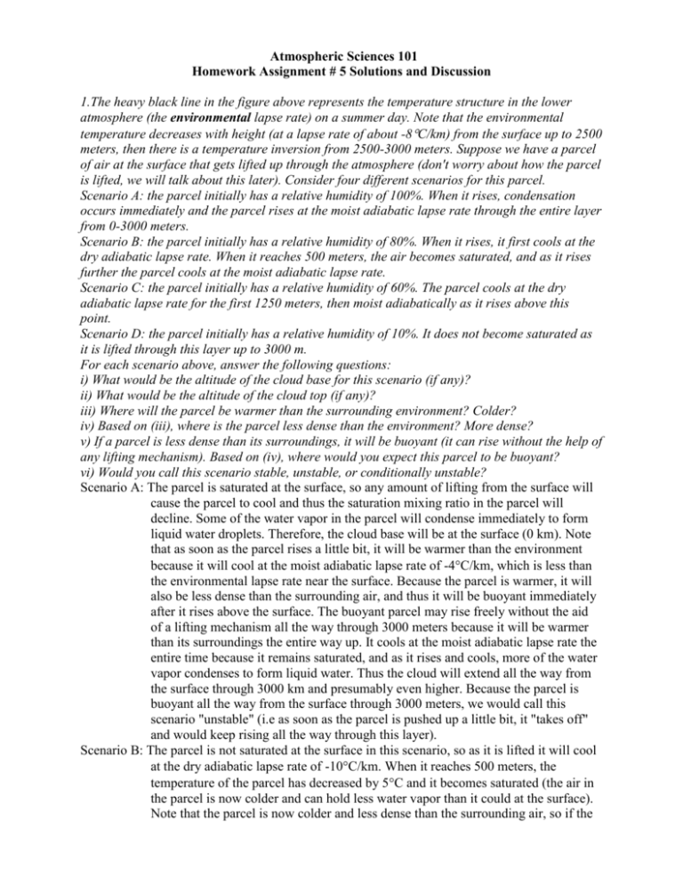
Atmospheric Sciences 101 Homework Assignment # 5 Solutions and Discussion 1.The heavy black line in the figure above represents the temperature structure in the lower atmosphere (the environmental lapse rate) on a summer day. Note that the environmental temperature decreases with height (at a lapse rate of about -8C/km) from the surface up to 2500 meters, then there is a temperature inversion from 2500-3000 meters. Suppose we have a parcel of air at the surface that gets lifted up through the atmosphere (don't worry about how the parcel is lifted, we will talk about this later). Consider four different scenarios for this parcel. Scenario A: the parcel initially has a relative humidity of 100%. When it rises, condensation occurs immediately and the parcel rises at the moist adiabatic lapse rate through the entire layer from 0-3000 meters. Scenario B: the parcel initially has a relative humidity of 80%. When it rises, it first cools at the dry adiabatic lapse rate. When it reaches 500 meters, the air becomes saturated, and as it rises further the parcel cools at the moist adiabatic lapse rate. Scenario C: the parcel initially has a relative humidity of 60%. The parcel cools at the dry adiabatic lapse rate for the first 1250 meters, then moist adiabatically as it rises above this point. Scenario D: the parcel initially has a relative humidity of 10%. It does not become saturated as it is lifted through this layer up to 3000 m. For each scenario above, answer the following questions: i) What would be the altitude of the cloud base for this scenario (if any)? ii) What would be the altitude of the cloud top (if any)? iii) Where will the parcel be warmer than the surrounding environment? Colder? iv) Based on (iii), where is the parcel less dense than the environment? More dense? v) If a parcel is less dense than its surroundings, it will be buoyant (it can rise without the help of any lifting mechanism). Based on (iv), where would you expect this parcel to be buoyant? vi) Would you call this scenario stable, unstable, or conditionally unstable? Scenario A: The parcel is saturated at the surface, so any amount of lifting from the surface will cause the parcel to cool and thus the saturation mixing ratio in the parcel will decline. Some of the water vapor in the parcel will condense immediately to form liquid water droplets. Therefore, the cloud base will be at the surface (0 km). Note that as soon as the parcel rises a little bit, it will be warmer than the environment because it will cool at the moist adiabatic lapse rate of -4C/km, which is less than the environmental lapse rate near the surface. Because the parcel is warmer, it will also be less dense than the surrounding air, and thus it will be buoyant immediately after it rises above the surface. The buoyant parcel may rise freely without the aid of a lifting mechanism all the way through 3000 meters because it will be warmer than its surroundings the entire way up. It cools at the moist adiabatic lapse rate the entire time because it remains saturated, and as it rises and cools, more of the water vapor condenses to form liquid water. Thus the cloud will extend all the way from the surface through 3000 km and presumably even higher. Because the parcel is buoyant all the way from the surface through 3000 meters, we would call this scenario "unstable" (i.e as soon as the parcel is pushed up a little bit, it "takes off" and would keep rising all the way through this layer). Scenario B: The parcel is not saturated at the surface in this scenario, so as it is lifted it will cool at the dry adiabatic lapse rate of -10C/km. When it reaches 500 meters, the temperature of the parcel has decreased by 5C and it becomes saturated (the air in the parcel is now colder and can hold less water vapor than it could at the surface). Note that the parcel is now colder and less dense than the surrounding air, so if the lifting mechanism were turned off when the parcel reached 500 meters, it would start to sink back to the surface, quickly becoming unsaturated and warming dry adiabatically. However, if the lifting mechanism lifted the parcel above 500 meters, liquid water would start to condense as the temperature and saturation mixing ratio decreased, so the cloud base would be at 500 meters and the parcel will cool at the moist adiabatic lapse rate as it continues to rise. Note that if the parcel is lifted up to 750 meters, it will become warmer than its surroundings. Thus it will also be less dense than its surroundings, and it can rise freely even if we now turn off the lifting mechanism (i.e. it is now buoyant). This continues until we reach about 2800 meters, at which point the parcel would again become colder and denser than the surrounding environmental air. If we assume the lifting mechanism is still operating above 2800 meters, then the parcel will keep rising, cooling, and condensing all the way through 3000 meters. However, if the lifting mechanism turned off somewhere below this point (which is usually true in the "real world"), then the parcel would not be buoyant above 2800 meters and we would expect the parcel to stop rising. Thus the cloud top would be located at 2800 meters (again, assuming that the lifting mechanism is no longer operating). Because the air parcel is buoyant only if we lift it up to 750 meters in this scenario, we would call it "conditionally unstable". Scenario C: Similar to scenario B, except that now saturation doesn't occur until the parcel is lifted to 1250 meters, and the parcel will be colder and denser than the surrounding environment until it is lifted up to about 1800 meters. From 1800 meters to about 2600 meters, the parcel would be warmer and less dense than the surrounding air, and thus buoyant. Above 2600 meters, the parcel would be colder and denser than the environment. Thus the cloud base would be 1250 meters, the cloud top would occur around 2600 meters (again, assuming the lifting mechanism "turned off" sometime between 1800 and 2600 meters), and we would again call this situation conditionally unstable. Scenario D: The parcel is so dry that it will remain unsaturated as we cool it dry adiabatically all the way through 3000 meters. Note that the parcel will always be colder and less dense than its surroundings. There will be no cloud formed by this parcel, and it will never be buoyant. This is a stable situation. Note that in this exercise we only considered a parcel at the surface. We could repeat the same exercise at any height and establish the stability of the atmosphere relative to a parcel originating at any level. Clouds in the atmosphere don't always form from parcels lifted from the surface; quite often, the clouds we see originated from air at intermediately levels. 2. In a few sentences of your own words, explain how each of the following types of fog form near the surface of the Earth. Be sure to include the time of year and the atmospheric conditions that are required: a) advection fog (1) Warm, moist air moves (is advected) over a colder surface. This surface could be water, land, or ice. (2) The warmer air is cooled because it is in contact with the colder surface below (heat is transported via conduction from the warm overlying air to the colder surface below, and the surface of the water doesn't warm up much because of its high specific heat). (3) When the moist air reaches its dewpoint temperature, it becomes saturated and liquid water droplets form (fog). Note that moist air can be advected over a cold surface without fog forming (i.e. as long as the temperature of the air remains above the dewpoint temperature). Thus (1) by itself is not enough. Likewise, the thing which distinguishes advection fog from the other types of fog is that warm air moves over colder water, thus (2) and (3) are also not a sufficient explanation. b) steam fog (1) Cold air moves over warm water. (2) Because the water is warm and the air above it is not saturated (yet), water evaporates from the water into the air above. (3) This process continues until the air becomes saturated and liquid water droplets form (fog). You can express this in two ways: (a) the relative humidity increases to 100% as the mixing ratio increases (while the saturation mixing ratio remains the same), or (b) the dew point temperature is raised until it matches the actual temperature. (4) The air near the surface is warmed from below (by conduction, convection and latent heat release as the water droplets form) and also accumulates water vapor (which is lighter than dry air), so the air near the surface becomes less dense than the air above it. Thus it rises, and we call it "steam". c) radiation fog (1) At night, the ground emits more energy (in the form of infrared radiation) than it receives from the Sun (visible radiation) and from the overlying atmosphere (infrared). Consequently, the ground cools (this is called radiational cooling). (2) A shallow layer of moist air in contact with the surface cools by conduction of heat from the air to the ground (refer to Problem 5a in Homework#4 for a complete explanation of the temperature inversion at the surface). (3) The air cools to its dewpoint temperature (i.e. the saturation mixing ratio decreases as the temperature drops), and liquid water droplets form (fog). Radiation fog can form in calm air, or in the presence of a slight breeze, which brings the moist air in contact with the cold ground. However, a stronger breeze or wind will prevent the formation of radiation fog, since the moist air will be continuously mixed with the drier air above, keeping the mixing ratio below the saturation mixing ratio (the turbulence will also tend to keep the surface air warmer because air near the surface is mixed upwards before it has a chance to cool to the surface temperature). In your answers, we looked to see that you mentioned the key processes involved in the formation of each type of fog. Giving an example is a good way to illustrate a point, but it is NOT a sufficient explanation of how fog forms. 3) The following two pictures represent different samples of liquid cloud droplets. (1) Keep in mind that many questions in meteorology still remain unanswered. Good measurements of size drop distributions in clouds have been made available to the scientific community only recently, and some clouds remain unexplored today (ex: the core of high cumulonimbus clouds). That is why some theories about the formation of clouds remain speculative and might be proven wrong in the future. (2) There is no "perfect" answer to this problem. However, many answers can be ruled out because they are physically unrealistic. Thus the point of this problem was to make you think about what we know about clouds, and see how you can apply it to eliminate as many cases as possible. If we wanted to find out about the exact type and composition of a given cloud, we would have given you complementary information (e.g. a temperature profile and vertical velocities). For this problem we graded your reasoning rather than your specific answers. (3) Figures 4.25 (summary of cloud types) and 5.14 (typical size of droplets and rain drops) could help you answering the questions. (4) Finally, note that most clouds do not precipitate (of course, Seattle is not the best place to prove this point!). Remember that very specific conditions are required for raindrops to form, grow, fall and reach the ground. a) The sample on the left was obtained on the roof of the Space Needle. What kind of cloud would you expect to see in the sky? Why? What kind of precipitation would you expect? Why? The droplets are slightly bigger than condensation nuclei and they have uniform size. Note that they are much too small to be raindrops, or even drizzle. Consequently, we must be in the cloud, and it is most likely a stratus cloud (which typically have small droplets and uniform droplet size distributions). Stratus clouds have small, uniform droplets for two reasons: (1) they form close to the surface and thus they usually have higher concentrations of CCNs; and (2) stratus clouds typically have small updraft velocities, so there is no mechanism for larger drops to form. Since we are only at the top of the Space Needle and the droplets are so small, we might just have "fog" (which is really a stratus cloud that touches the surface) It is highly unlikely that there is any rain associated with a cloud having these characteristics, although if it was indeed "fog" then you might be able to see and feel the tiny droplets around you (although technically this would not be precipitation). b) The sample on the right was obtained from an airplane flying over Seattle at 5000 meters. What kind of cloud would you expect to see in the sky? Why? What kind of precipitation? Why? Since we are flying at 5,000 meters, the only clouds that we could encounter would be altocumulus, altostratus or cumulonimbus (or possibly cumulus congestus). Keep in mind that "cumulus" by itself implies "fair weather cumulus" clouds, which do not reach this high in the atmosphere. As soon as there is significant vertical build-up, the terms "cumulus congestus" and then "cumulonimbus" are used. Even though the droplets are bigger than those in sample 1, note that they are not very large when compared to typical cloud droplets and rain drops. Because the droplets are rather small, you could argue that we are inside an altostratus cloud. However, there is a wider size range here than in sample 1, which indicates that there is some collision and coalescence of the cloud droplets occurring, implying that the vertical velocity in this cloud is greater than the cloud in sample 1. Given these conditions, this sample was most likely obtained inside an altostratus cloud or a developing cumulonimbus. Note that at 5000 meters we are almost certainly below the freezing point of water, so we probably have supercooled liquid water droplets. We definitely have neither a cirrus cloud (these are found higher up in the atmosphere and are made of ice crystals), nor a nimbostratus cloud (a term used for a lower layered cloud with low cloud base, precipitation, and moderate vertical extension of less than 5000 m). c) Would you ever expect to see the sample on the left at an altitude of 5000 meters? Under what conditions? At 10,000 meters? Again the droplets in sample 1 are very small and they are uniformly distributed. If you were to see them in a cloud at 5000 meters, they would be in an altostratus. The droplets would be tiny supercooled liquid water droplets at this altitude. (However, they are probably too small even for this scenario). Note that this cloud probably would not form due to a parcel of moist air lifting up from the surface. In class, we emphasized convection at the surface and lifting mechanisms associated with surface fronts, but they are not the only mechanisms responsible for the formation of clouds. An altostratus could form between 3000 and 6000 meters by an independent lifting mechanism, decoupled from the surface. At 10,000 m, we can expect temperatures as low as -40C or even -50C. At those temperatures, any water in condensed form would be ice crystals , so we would not see sample 1 at this elevation. d) Would you expect to see the sample on the right at 10,000 meters? Under what conditions? For the same reason as above, you would expect to find ice crystals at 10,000 m. Arguably, you could imagine an extremely intense cumulonimbus cloud in which pockets of air are lifted up to 10,000 m in such a way that you could still observe supercooled liquid water droplets. This is definitely possible around 7000 or 8000 meters. Higher up in a cumulonimbus, the answer is not as clear as we would like. At the equator, where the tropopause is much higher (15 km or more), this could be achieved more easily. Again, we don't really have any measurements of cloud droplets at this altitude, so we don't really know for sure. 4) Cloud Journal mini-project: On Monday, February 15th, Tuesday, February 16th, and Wednesday, February 17th, 1999, answer the following questions about the weather outside (if you are out of town on one these days at 11:30 a.m., describe the clouds where you are and draw a quick sketch). a) What is the approximate temperature outside? b) Is there any precipitation? If so, is it rain, drizzle, snow, or something else? c) What direction is the wind blowing from at the surface? Estimate the wind speed. (See page 149 in the book to see how you should express wind direction) d) What percentage of the sky is covered with clouds? e) What type(s) of cloud(s) do you see in the sky? Look in the back of the textbook or ask us if you need help naming the clouds. f) Are the clouds that you see high clouds, middle clouds, or low clouds? g) Based on the direction that the clouds are moving, what do you think the wind direction at the level of the clouds is (again, use page 149). Are the clouds stationary, moving slowly, moving fast, or moving really, really fast? Do you think the wind is stronger at the surface or aloft? Your answers will vary depending on exactly when are where you made your observations. Basically, all three days we had temperatures in the low to mid 40's, southerly winds at the surface at 5-15 knots, 80-100% cloud cover (composed mostly of low stratocumulus clouds), an intermittent drizzle, and southwest winds aloft at 35-50 knots. Remember that we name winds in meteorology based on where the wind is coming FROM (i.e. a "southwesterly" wind is blowing from SW to NE. 5) Pick two of the following review questions from Chapter 15 in the book and answer them in a paragraph or less (use your own words and include a diagram): 5, 11, 13, 14, 18, 19. The book contains a decent explanation of all of these phenomena, so we will not waste time and space rewriting the answers to all of the review questions here. We deducted points if you did not include a drawing for each question, if you merely copied word for word the explanation in the book, if you wrote something that was obviously wrong, or if your answer was not complete. Again, make sure that you know what the key terms "scattering", "diffraction", "refraction", and "reflection" mean, and that you know which of these processes are responsible for each of the various optical phenomena.
