8th grade Changing Earth - North East Independent School District
advertisement
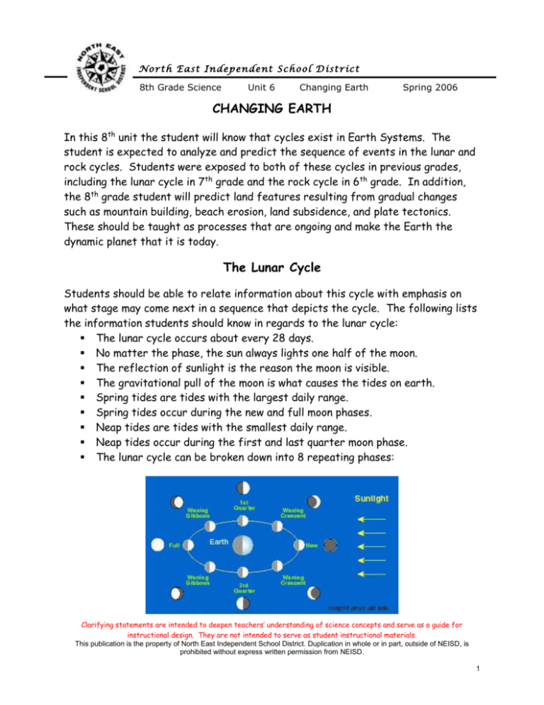
N o r t h E a st I n d ep en d e nt S c h o o l D i st ric t 8th Grade Science Unit 6 Changing Earth Spring 2006 CHANGING EARTH In this 8th unit the student will know that cycles exist in Earth Systems. The student is expected to analyze and predict the sequence of events in the lunar and rock cycles. Students were exposed to both of these cycles in previous grades, including the lunar cycle in 7th grade and the rock cycle in 6th grade. In addition, the 8th grade student will predict land features resulting from gradual changes such as mountain building, beach erosion, land subsidence, and plate tectonics. These should be taught as processes that are ongoing and make the Earth the dynamic planet that it is today. The Lunar Cycle Students should be able to relate information about this cycle with emphasis on what stage may come next in a sequence that depicts the cycle. The following lists the information students should know in regards to the lunar cycle: The lunar cycle occurs about every 28 days. No matter the phase, the sun always lights one half of the moon. The reflection of sunlight is the reason the moon is visible. The gravitational pull of the moon is what causes the tides on earth. Spring tides are tides with the largest daily range. Spring tides occur during the new and full moon phases. Neap tides are tides with the smallest daily range. Neap tides occur during the first and last quarter moon phase. The lunar cycle can be broken down into 8 repeating phases: Clarifying statements are intended to deepen teachers’ understanding of science concepts and serve as a guide for instructional design. They are not intended to serve as student instructional materials. This publication is the property of North East Independent School District. Duplication in whole or in part, outside of NEISD, is prohibited without express written permission from NEISD. 1 N o r t h E a st I n d ep en d e nt S c h o o l D i st ric t 8th Grade Science Moon Phase new moon Diagram Unit 6 Changing Earth Spring 2006 Explanation no moon is visible as the sunlit portion does not face Earth waxing crescent seen as a small crescent / slice of the moon as the sunlit portion is increasing in size from day to day first quarter seen as one half of the moon as the sunlit portion continues to increase in size from day to day Note: The first quarter moon looks like a right half of a circle. seen as a greater than quarter but less than a full moon as the sunlit portion is increasing in size from day to day waxing gibbous full moon the entire sunlit side of the moon is visible waning gibbous seen as greater than a quarter but less than a full moon as the sunlit portion begins to decrease in size from day to day last quarter seen as one half of the moon is lit as the sunlit portion is decreasing in size from day to day Note: The first quarter moon looks like a left half of a circle. seen as a tiny slice of the moon as the sunlit portion continues to decrease in size from day to day waning crescent Clarifying statements are intended to deepen teachers’ understanding of science concepts and serve as a guide for instructional design. They are not intended to serve as student instructional materials. This publication is the property of North East Independent School District. Duplication in whole or in part, outside of NEISD, is prohibited without express written permission from NEISD. 2 N o r t h E a st I n d ep en d e nt S c h o o l D i st ric t 8th Grade Science Unit 6 Changing Earth Spring 2006 The Rock Cycle All rocks are made of minerals. Students should know that these minerals combine to form three basic rock types: igneous, sedimentary and metamorphic. The 8th grade student should know how each type is formed and be able to predict how one rock may change into another through the processes that are a part of the rock cycle. Students should not be responsible for matching the name of a rock with its classification, but they should be able to look at a sample and hypothesize how it was formed through the processes that are a part of the rock cycle. In order for students to understand the origins of rocks, it would be appropriate to review the basic layers of the earth. The earth has three basic layers: the crust, mantle and core. The crust is the thin, outermost layer made of rock. The mantle is the largest layer and contains magma. The core is the Earth’s hot, dense center layer. The outer core is liquid while the inner core is solid from intense pressure. The primary elements in the core are iron and nickel. This is because they are very dense and pulled towards the center by gravity. Students have learned about these layers in the past, but they may not be familiar with the sublayers including the lithosphere, asthenosphere and mesosphere. The lithosphere consists of the crust and the uppermost, somewhat rigid portion of the mantle. It is divided into the tectonic plates. The asthenosphere is made of the magma upon which the tectonic plates slowly move. The mesosphere is the solid, lower part of the mantle that lies above the core. Clarifying statements are intended to deepen teachers’ understanding of science concepts and serve as a guide for instructional design. They are not intended to serve as student instructional materials. This publication is the property of North East Independent School District. Duplication in whole or in part, outside of NEISD, is prohibited without express written permission from NEISD. 3 N o r t h E a st I n d ep en d e nt S c h o o l D i st ric t 8th Grade Science Unit 6 Changing Earth Spring 2006 Igneous rocks form from either magma or lava. Both of these are molten rock. Magma is found underground. When it comes to the surface through a fissure or volcanic eruption, it undergoes a chemical change as it is exposed to the atmosphere. At this point, the molten rock is referred to as lava. If the igneous rock forms from magma that has cooled and hardened underground, it is an intrusive igneous rock. Rocks that form when magma cools slowly will have large crystals as they are afforded time to grow. Granite is a good example of a slow cooling, intrusive igneous rock. Rocks that form when magma cools quickly will have small crystals. Basalt is a good example of a fast cooling, intrusive igneous rock. Sedimentary rocks form from the weathered sediments of other rocks. Weathering occurs through forces such as wind, water, ice, organisms, etc. Erosion carries the resulting sediment from one place to another. Deposition of the sediment occurs in layers. Over time, the pressure of overlying layers causes the sediment to become compacted and cemented together. As a result of this process, many sedimentary rocks appear to have strata. Sedimentary rocks are made from the compaction and cementation of different materials. There are different methods through which sedimentary rocks my form. Some are formed by mineral and rock fragments, such as conglomerate, sandstone, and shale. Organic material may also combine to form sedimentary rocks. A common example would be limestone which is formed from the shells of once living sea creatures. Limestone, however, may also form when minerals precipitate out of solution, collect and harden. Metamorphic rocks form from other rocks being heated and put under tremendous pressure. Students should understand rocks that undergo metamorphosis are not melted. In order for a rock to change, it must first be buried. Exposure to a heat source and the weight of overlying rock layers then begins the metamorphic process. Marble is an example of a metamorphic rock that forms from limestone. The rock cycle describes how the form and structure of rocks is constantly changing. It is comprised of the following processes: Melting: Heating within the Earth causes rock to melt and form magma. Clarifying statements are intended to deepen teachers’ understanding of science concepts and serve as a guide for instructional design. They are not intended to serve as student instructional materials. This publication is the property of North East Independent School District. Duplication in whole or in part, outside of NEISD, is prohibited without express written permission from NEISD. 4 N o r t h E a st I n d ep en d e nt S c h o o l D i st ric t 8th Grade Science Unit 6 Changing Earth Spring 2006 Cooling and Hardening: Magma rises towards/to the surface, cools and hardens. Weathering, Erosion and Deposition: Weathering is the breakdown of rock into sediment. Erosion is the movement of that sediment. Deposition is the process by which the sediment is dropped in a new location. Compacting and Cementing: Pressure compacts sediment together. Water between particles evaporates, leaving minerals that cement sediments together. Heat and Pressure: Heat comes from either direct contact or nearby contact with magma. Pressure from overlying rock layers squeezes minerals in rocks. These two processes may work to actually change the identity of a rock. The following is a diagram of the rock cycle. Students should be very familiar with a diagram such as this. It is essential that they are able to predict the processes involved in a sequence which may lead to change and/or formation of a rock. Students also need to understand that any type of rock may change into another type of rock. Clarifying statements are intended to deepen teachers’ understanding of science concepts and serve as a guide for instructional design. They are not intended to serve as student instructional materials. This publication is the property of North East Independent School District. Duplication in whole or in part, outside of NEISD, is prohibited without express written permission from NEISD. 5 N o r t h E a st I n d ep en d e nt S c h o o l D i st ric t 8th Grade Science Unit 6 Changing Earth Spring 2006 Most of the process appearing in the rock cycle are gradual. Over time such Earth processes can result in land features such as mountains, beaches and areas of subsidence, just to name a few. Movement of tectonic plates is a major force in the changing of the Earth’s surface. Plate Tectonics Alfred Wegener wrote about theory of continental drift in 1912. He observed that the eastern edge of South America fits uniquely into the western edge of the Africa. He also noted similar fossils dating back to the same age were found in both South America and Africa. Wegener suggested that at one time in the history of the development of earth all the continents were actually only one large continent called Pangaea which means “all land.” Similar rock types, climate clues, and fossils were the main evidence that supported the theory of continental drift. Over time, science advanced, the ocean floors could be studied in more detail and seafloor spreading was discovered. Magnetic reversals in the bands found on either side of a diverging oceanic plate provided support for Wegener’s theory. Today, the theory that the lithosphere is divided into tectonic plates that move on top of the mantle’s asthenosphere is referred to as “plate tectonics.” The term “continental drift” is no longer used as it is misleading in regards to the actual method and process of what occurs. Clarifying statements are intended to deepen teachers’ understanding of science concepts and serve as a guide for instructional design. They are not intended to serve as student instructional materials. This publication is the property of North East Independent School District. Duplication in whole or in part, outside of NEISD, is prohibited without express written permission from NEISD. 6 N o r t h E a st I n d ep en d e nt S c h o o l D i st ric t 8th Grade Science Unit 6 Changing Earth Spring 2006 The 8th grade student has been exposed to the term “tectonic plate,” but has not previously been taught the mechanism of plate tectonics or been given a thorough lesson on types of plate boundaries and the earth features that occur at each one. Students should apply the principle that hot materials expand and rise and then become cooler and more dense, leading them to sink again. A lava lamp is a good model to help students make this connection. The cyclical rising and sinking of molten material in the asthenosphere is the driving force behind the movement of tectonic plates. The convection currents created act like a conveyor belt that actually will pull plates along. This process is known as slab pull, referring to a tectonic plate as the “slab.” Tectonic plates collide at convergent plate boundaries. Different processes occur at these boundaries depending on the composition of the plates. When two continental plates collide, they will buckle and crust will be pushed upwards. A good example is where the Indian Plate collided with the Eurasian Plate. The result of this collision was the formation of the Himalayan Mountains. When continental and oceanic plates collide, the oceanic crust will slide under the continental crust in a process known as subduction. This occurs because the oceanic crust is more dense. The region where the process happens is referred to as a subduction zone. As the oceanic crust sinks lower into the mantle, it will melt and form magma. This may create a “hot spot” where magma rises. A subduction zone exists at the boundary between the South American Plate and Nazca Plate. The result is the Clarifying statements are intended to deepen teachers’ understanding of science concepts and serve as a guide for instructional design. They are not intended to serve as student instructional materials. This publication is the property of North East Independent School District. Duplication in whole or in part, outside of NEISD, is prohibited without express written permission from NEISD. 7 N o r t h E a st I n d ep en d e nt S c h o o l D i st ric t 8th Grade Science Unit 6 Changing Earth Spring 2006 formation of the Andes mountains, volcanoes, and frequent earthquakes. When two oceanic plates collide, the one that denser will be subducted. Volcanic islands, such as the Hawaiian and Aleutian Islands, are created by this process. Clarifying statements are intended to deepen teachers’ understanding of science concepts and serve as a guide for instructional design. They are not intended to serve as student instructional materials. This publication is the property of North East Independent School District. Duplication in whole or in part, outside of NEISD, is prohibited without express written permission from NEISD. 8 N o r t h E a st I n d ep en d e nt S c h o o l D i st ric t 8th Grade Science Unit 6 Changing Earth Spring 2006 Divergent boundaries exist where two plates are moving away from one another. Most of these boundaries are located in oceans. The mid-ocean ridge in the Atlantic is an example of where this is occurring. As plates diverge at the ridge, new magma rises, cools and hardens. This forms new oceanic crust in a process referred to as sea-floor spreading. The Great Rift Valley in Africa is an example of a divergent boundary on land. Seas and volcanoes are the result of tectonic activity in this area. At some point in the future, the rift may be large enough to separate the land masses completely, creating a new mid-ocean ridge. Rift Zone As convergent and divergent boundaries are discussed in the classroom, an important connection can be made to previous units of study. The constant creation and subduction of crust is an example of the application of the Law of Conservation of Mass. These tectonic processes create a state of equilibrium, a concept first introduced at the 7th grade level in regards to volcanic eruptions. Transform boundaries occur where two tectonic plates slide past one another. The grinding and slipping at these boundaries often causes earthquake activity. California is located on two different plates, the North American and Pacific. The movement of these two plates along the San Andreas fault is responsible for the high number of earthquakes that occur in this region. Clarifying statements are intended to deepen teachers’ understanding of science concepts and serve as a guide for instructional design. They are not intended to serve as student instructional materials. This publication is the property of North East Independent School District. Duplication in whole or in part, outside of NEISD, is prohibited without express written permission from NEISD. 9 N o r t h E a st I n d ep en d e nt S c h o o l D i st ric t 8th Grade Science Unit 6 Changing Earth Spring 2006 Transform Boundary Mountain Building The lifting of land by forces in the Earth’s crust, or uplift, is one of the major forces that creates mountains. Different types of plate movements are responsible for the different types of mountains. There are three basic mountain types: Volcanic, Folded and Fault-block. Volcanic mountains can occur at either convergent or divergent boundaries as magma rises to the surface as a result of subduction or sea-floor spreading. Folded mountains form from the folding, or bulging, that occurs when crust collides and is pushed upwards at convergent boundaries. The Rockies, Himalayas, Andes and Alps are all examples of folded mountains. Fault-block mountains form when large pieces of crust fall and rise alongside each other as plates diverge. Fault-block mountains are very common near mid-ocean ridges. Examples on land include the Tetons and Sierra Nevadas. Land Subsidence Subsidence is essentially the opposite of uplift. Land subsidence is the sinking of land that occurs either as a result of geologic processes or human activities. Tectonic activity can cause subsidence in two ways. As plates moving in different directions pull apart, a rift zone will form. The crust in the center of the rift zone will subside, leaving a fissure. In areas where sea-floor spreading occurs, new hot crust is added to the ocean floor. As the spreading continues, this crust cools, and sinks because it now takes up less space/volume. Subsidence can also happen as a Clarifying statements are intended to deepen teachers’ understanding of science concepts and serve as a guide for instructional design. They are not intended to serve as student instructional materials. This publication is the property of North East Independent School District. Duplication in whole or in part, outside of NEISD, is prohibited without express written permission from NEISD. 10 N o r t h E a st I n d ep en d e nt S c h o o l D i st ric t 8th Grade Science Unit 6 Changing Earth Spring 2006 result of human activity. Sinkholes often occur where man-made voids, such as tunnels, wells and quarries, have a weak roof of earth above them. This same form of subsidence may also take place over natural caves. Another common cause of subsidence due to human activity is from excessive withdrawal of underground resources, including petroleum and water. The following is an example of how groundwater removal may result in sediment compaction and the subsidence of the ground surface: Step 1: The weight of the overlying material is supported by both sediment grains and the water in the pore spaces between these grains. Step 2: Pressure from water on the surrounding grains keeps the pore space open. Step 3: When the water is extracted, sediment grains may collapse inward on the pore space. Topographic Maps The 2005 TAKS Information Booklet states the following: “Students should be able to interpret and evaluate graphs, charts, and maps. Maps may include topographic contour maps, in which each line on the map represents a change in elevation and differences in spacing between lines indicate relative steepness of slopes.” The 8th grade lessons on mountain building and land subsidence provide a natural connection to reading topographic maps. Changes in elevation on a topographic map may represent hills, mountains, valleys or areas of subsidence. Students should be able to interpret a topographic map to determine the major landforms depicted. In addition to understanding elevation lines and spacing as an indicator of steepness, the student needs to be able to interpret information given about the map, such as contour interval and scale measurements. Students should also know that certain features, such as rivers, may cut across contour lines. Clarifying statements are intended to deepen teachers’ understanding of science concepts and serve as a guide for instructional design. They are not intended to serve as student instructional materials. This publication is the property of North East Independent School District. Duplication in whole or in part, outside of NEISD, is prohibited without express written permission from NEISD. 11 N o r t h E a st I n d ep en d e nt S c h o o l D i st ric t 8th Grade Science Unit 6 Changing Earth Spring 2006 Example of a topographic map depicting a hill Beach Erosion A beach is any area of the shoreline made up of material deposited by waves. Shorelines made of sand, coral, or rock can be washed away over time through the action of waves, wind, storms, currents, and development by human activity. This is a land feature generally not affected by tectonic activity. There have been many attempts by man to stop the erosion; examples would be building jetties, building sea walls, and dumping more sand where the sand has washed away. It is not known, however, if these attempts will actually help or do more harm. The 8th grade student should be exposed to examples of coastal landforms. They should not be required to memorize the names of specific beach features, but they should have experience in looking at a feature and formulating a hypothesis as to how it was created, drawing on their prior knowledge. Primary emphasis will be on wave erosion which is responsible for features such as sea stacks, sea caves, sea arches, terraces, etc. Clarifying statements are intended to deepen teachers’ understanding of science concepts and serve as a guide for instructional design. They are not intended to serve as student instructional materials. This publication is the property of North East Independent School District. Duplication in whole or in part, outside of NEISD, is prohibited without express written permission from NEISD. 12

