Roeburn Restoration Project Proposed Actions There are 4 high
advertisement

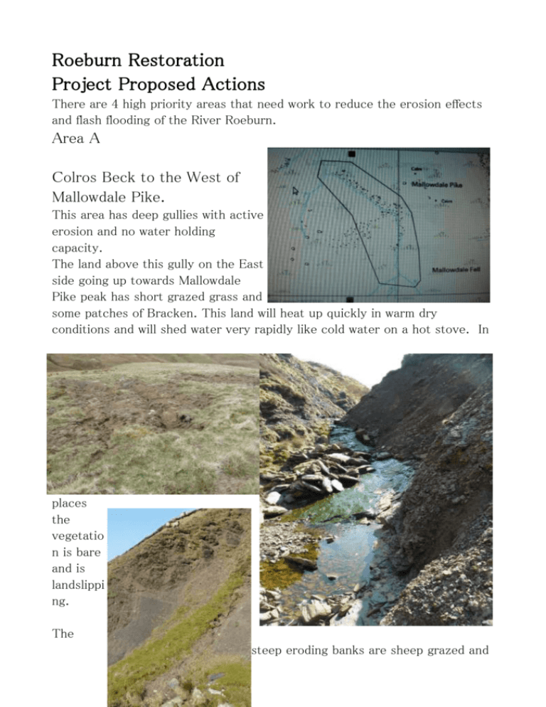
Roeburn Restoration Project Proposed Actions There are 4 high priority areas that need work to reduce the erosion effects and flash flooding of the River Roeburn. Area A Colros Beck to the West of Mallowdale Pike. This area has deep gullies with active erosion and no water holding capacity. The land above this gully on the East side going up towards Mallowdale Pike peak has short grazed grass and some patches of Bracken. This land will heat up quickly in warm dry conditions and will shed water very rapidly like cold water on a hot stove. In places the vegetatio n is bare and is landslippi ng. The steep eroding banks are sheep grazed and the sheep tracks are initiating areas for erosion. The gully stream bed has sharp angular bends showing the aggressive nature of the water flow. A small area of wet land remains at the top of the gully. The proposal for this area is to sheep fence around the worst part of the gully and its immediate catchment area (1.6Km of fence). This will enable the vegetation to grow and hopefully the dwarf shrubs such as heather and bilberry with mosses will give this land some protection from direct rain erosion and will cool the land reducing the speed of run off. It will remove the additional destabilisation from sheep tracks.In the longer term establishing some hawthorn and rowan shrubs would help keep this land cooler.. In the gully check dams are needed for a section with a fall of 84 metres over a length of 700 metres.(1:8.3) These will slow down the water flow and reduce erosion. Holding the water in the landscape will help the water to percolate into the ground water. In the longer term the aim would be to re-establish the woodland cover in this Beck. A few remaining trees of rowan, birch, holly, hawthorn alder and oak still hang on on the eroding banks. Once reestablished this woodland will help cool the water and reduce flooding risk. Area B Warm Beck Gill This gill runs down from Whitmoor down to Winder Wood. An area above here was gripped for drainage in the 1950's. This combined with high sheep numbers may have led to the start of this erosion. At the top of this gully there is active peat erosion extending the gully Southwards. The water flows through rushes and then drops into a 1 metre deep peat channel for about 30 metres. Then there is a 2 metre drop into the gully top. The gill has under cut the banks and there are many areas of steep shale banks with active erosion. A track over this gill is badly eroded. Because this gill is South facing the water in it will heat up rapidly and with heavy cold storm rain will create horizontal vortices in the water leading to flooding and active erosion. The lower area of the gill has been stock fenced and the vegetated banks planted with trees. There is still active bank erosion in this area. The fall is 53 metres over a distance of 430 metres. (1:8.1)Below this area there is gully formation in Winder Wood. The proposal for this area is to fence off the eroding area from sheep (0.55km fence) to prevent further erosion from sheep tracks and to allow the vegetation to grow higher. In the top peat ditch small dams will help slow this down and re-establish rushes and mosses to hold and protect the water and peat. The 2 metre drop will need a stone face and apron building to stop the gully extending higher. In other areas of the valley gorse has established on shale banks. It is suggested that gorse seedlings and gorse seed should be planted on these eroding areas. In the long term the gorse will provide nitrogen rich soil where tree seedlings such as hawthorn, holly, rowan, birch alder and oak can establish. Check dams along the base of this gully will slow the water flow down reducing its erosive force and allowing some water to infiltrate into the ground water. The above is the minimum needed. Ideally the sheep grazing numbers could be reduced on the catchment area to allow the sphagnum mosses and dwarf shrubs to re establish as tussocks and hold water in the landscape. Another possibility is to re- establish woodland onto the area that was gripped. Signs of the past woodland are evident in the eroding peat. This would help both area B and C. These would only happen with a positive response from the farmer. Area C This is an area where the stream runs off Whitmoor from a 1950's gripped area between Little Scar and Back farm. A concrete culvert pipe put through under the Roeburndale West Road replacing a stone culvert was consructed in a way that altered the angle of flow initiating erosion. A leat which used to supply water to Backsbottom Quarry up to around 1910 is now about 8 metres above the current stream level. Very rapid erosion. Fortunately gorse has established in this gully and has stabilized most of the bank. The stream bed is still eroding and where it enters Back Wood it is undercutting the bank and causing bad landslip Above the woodland the fall is 50 metres over a length of 240 metres (1:4.8) within the woodland the fall is 84 metres over 580 metres down to Miller Paddock.(1:6.9). In Miller paddock the original stream bed altered during the Wray Flood 1967. This used to be an excellent spawning ground for the sea trout. This stream dried up in 2010 for the first time in over 50 years. During flood conditions large quantities of shale are deposited on the banks. It is proposed that the stream bed is stabilized and water flow slowed down with check dams. Within the woodland bank stabilization will be tried with both gorse seeding and planting of fresh alder stakes which will grow and help reduce the erosion. Area D This is a steep eroding bank within Roeburndale Woods SSSI. This bank was under cut by the 1967 flood and has been eroding ever since. The heavy trees on the bank were felled around 2007 to reduce the tree weight pulling the landslip into the river. The landslip is still active. Proposal to dig a ditch at the top of the slope to divert the small water flow at the top of the landslip in a different direction. At the base of the slope alder logs should be laid and pinned to the bank. These should take root and stabilize this area. Another area further down the river has been protected in this way. On the eroding slope this may be stabilized with gorse seeding and fresh alder stakes. Other areas for action. More check dams and sheep fencing. There are many other landslip and gully areas within Roeburndale which would benefit from addition of check dams and sheep fencing. Detailed survey to identify these areas in conjunction with farmers and landowners will be carried out. Pond creation. More water needs to be held in the landscape to help fill the ground water which feed the deep springs. The proposal is to work with farmers and landowners to identify suitable sites for creating 5 ha of deep ponds. Ideally these will be in positions where water can be led into them with swales removing the water from eroding streams. One area has been identified on lower Whitmoor. Creation of U shaped river bed with deep pools. The river bed is flat in most of Roeburndale. The placement of boulders in the river bed to encourage the creation of deeper pools and a more U shape to the river bed will be explored. The would be based on the work of Otman Grober in Austria. Other actions Fencing and hedge planting along the contours will help slow water flow down. Spiking the ground helps water to sink into fields holding the water over dry periods. Contour swales will help water penetrate into the ground. Woodland creation helps to catch water. Low grazing levels allowing tussocky growth helps hold water. Overall Aims To build 400 check dams. To create 5 ha of ponds. To erect 6 km of stock fencing and gates to protect land from grazing erosion. Monitoring Project In order to monitor the success of the project the following monitoring would be useful: Regular survey of Macro invertebrates in the river. Fish survey. Water flow and depth monitoring in the river. Rain and river water temperature. Number of times the river floods. Survey of otters to indicate the health of the river. Education The problems that occur in Roeburndale are similar to those in disaster flood areas. The Cockermouth floods source can be identified from a washed out area of mires. Middle Wood Trust will develop educational resources using a combination of science and arts to help promote an understanding of water flow in the landscape and how it is affected by temperature. This understanding is needed for future generations as well as agencies active with water management. It is evident that there is a lack of knowledge in this area. Middle Wood Trust and Backsbottom Farm are organising a water gathering in August 2012 to work with Open Space organisation to start to develop this educational side. Science, music, sculpture, art and puppetry will be included. The aim will be to run a Water Festival in 2013. Water education would become part of the HLS educational visits for Backsbottom Farm. Dr Rod Everett Backsbottom Farm, Roeburndale West, Lancaster, LA2 9LL 015242 22214


